Sunny, seasonable Friday in Philadelphia region before weekend storms. Here's the weather forecast.
The workweek in the Philadelphia region will end on Friday with sunshine and seasonable highs in the 40s.
Our meteorologists have declared Sunday-Thursday NEXT Weather Alert Days as the Philadelphia area prepares for significant weekend snow and the coldest air since 2018 next week.
As we head into the holiday weekend, here's what our team is tracking as more storms and snow are on the way.
Martin Luther King Jr. holiday weekend weather in Philadelphia
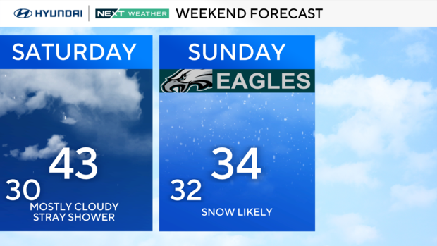
We are tracking another system on Saturday with rain showers during the day. Highs will reach the low 40s. Cold air slides in behind this system, creating an interesting setup for Sunday.
On Sunday, a different disturbance tracks through the deep south to the Tennessee Valley and off the Carolina coast as a coastal storm. Then it travels north of the Jersey Shore, bringing a good chance of snow showers Sunday mid-morning through the early evening.
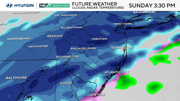
The snow is expected to start between 9 and 11 a.m. and will end around 9 p.m.
Chief Meteorologist Bill Kelly suggests that residents in the Philadelphia region shovel and clear out the areas they need to once the snow stops Sunday night. Temperatures are expected to drastically drop as the coldest air we've seen in years moves in on Monday which means icy conditions.
Significant accumulations are likely and could range from several inches to more than half a foot depending on the final track. There will be some banding across the area with bursts of heavy snow up to 1 inch per hour. Thundersnow may develop.
Travel will be difficult on Sunday with snow-packed roads in some places. Plan on air cancellations and rail delays. The Eagles and Rams will be playing in the snow. Temperatures at kickoff at 3:30 p.m. Sunday will be 34 degrees with a north wind of 5-10 mph. The wind chill will have temperatures feeling like it's 29 degrees.
For MLK Day on Monday, winds increase and temperatures begin to plummet, but at least the sunshine returns. Temperatures will be frigid in the teens to start the day and only reach the mid-20s. By Monday night we drop to the single digits in the city and near or below zero in some areas away from the city.
Tuesday and Wednesday will only see highs in the mid-teens with lows across the region between -2 and 9 degrees. Wind chills will dip to -10 to -20 at night with the feels like between 0 to 10 during the day.
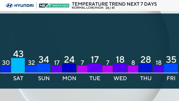
Here's your 7-day forecast:
Friday: Sunny. High 42, Low 26.
Saturday: A shower. High 43, Low 30.
Sunday: NEXT Weather Alert for snow. High 34, Low 32.
Monday: NEXT Weather Alert for cold. High 24, Low 17.
Tuesday: NEXT Weather Alert for cold. High 17, Low 7.
Wednesday: NEXT Weather Alert for cold. High 18, Low 7.
Thursday: NEXT Weather Alert for cold. High 28, Low 8.


