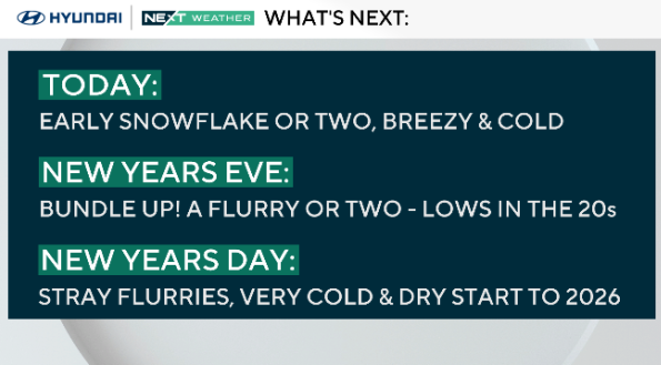
Some snow showers possible in Philadelphia region for New Year's Eve. Here's the weather forecast.
Wednesday stays cold and unsettled at times as the region remains caught between low pressure to the north and high pressure to the south.
Another weak disturbance and cold front move through tonight, bringing a chance for snow showers, especially north and west, where a light coating is possible in the higher elevations.
Otherwise, it stays breezy with highs in the low to mid 30s and feels-like temperatures in the 20s.
NEXT big weather change
Colder air settles in behind a front that moves into region tonight and into Thursday.
Thursday turns windy and colder, with highs mainly in the 20s and low 30s and wind chills well below freezing.

Friday remains dry and cold but less windy, with temperatures slowly moderating into the 30s. The weekend looks quiet and dry, while the next chance for light precipitation arrives early next week.
We'll finally rebound and see some 40s in the forecast by next Tuesday.
Here's your 7-day forecast:
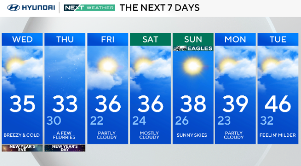
Wednesday/New Year's Eve: Breezy and cold. High 35.
Thursday/New Year's Day: Few flurries. High 33, low 30.
Friday: Partly cloudy. High 36, low 22.
Saturday: Mostly cloudy. High 36, low 24.
Sunday: Sunny skies. High 38, low 26.
Monday: Partly cloudy? High 39, low 23.
Tuesday: Feeling milder. High 46, low 32.