A front brings snow squalls, and winter's worst cold yet, to the Philly area. Here's the weather forecast.
The Philadelphia region will have another day above freezing before the coldest blast of this winter season so far hits overnight. Then, an Arctic cold front is our next big weather story.
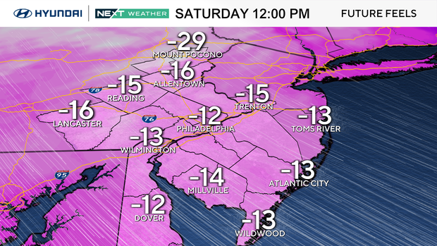
Remember last week's frigid temperatures? It will be even colder than that. We'll be under a NEXT Weather Alert, and an extreme cold warning is in place for the entire area from Saturday morning into Sunday morning, when wind chills could be colder than -10 (or -20 in the Lehigh Valley and Poconos).
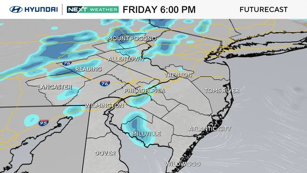
When snow squalls, showers could arrive in Philly region
This front will blast through overnight Friday into Saturday in the Philadelphia region with snow showers and squalls likely between 6 p.m. and 4 a.m.
It can lead to a quick accumulation in spots as well as very low visibility for drivers. Totals will be pretty low, less than an inch, but be careful if traveling Friday night.
Temps will plunge early Saturday, and wind chills will struggle to get above zero MOST of the weekend. Winds themselves will likely gust upwards of 40 mph for a time — with gusts as high as 50 mph in the city and 60 mph at the Jersey Shore.
We have a wind advisory in effect for the majority of the area, and a high wind warning in effect at the shore and in southern Delaware.
What is a snow squall? Here's the meaning of the winter weather term
What is a snow squall? It's a brief and intense burst of heavy, wind-driven snow. Snow squalls can occur with very little warning and can lead to whiteout conditions on the roads, and also drop a quick accumulation of snow that can lead to very slippery conditions.
Snow squalls can come up on drivers suddenly and can lead to near zero visibility within minutes. They usually occur along cold fronts, but can also happen with lake effect snow too.
How does a snow squall differ from a snow shower? Think of summer weather and the difference between a shower (generally short lived period of rain, not generally accompanied by strong winds) and a thunderstorm (intense downpour and often accompanied by strong winds).
Just because of their intensity, snow squalls can be thought of as the "thunderstorm of winter" even though they are not often accompanied by thunder and lightning.
More on the coldest air of the season so far
Air temperatures may drop to the single digits Saturday and no better than the teens in the afternoon — a brutally and dangerously cold day.
Wind chills may even approach 15 below zero near the city, and at that level of cold, frostbite can develop within 30 minutes. Even colder wind chills in the Poconos are likely Saturday and Saturday night. It won't be as strong Sunday, but wind chills will stay below 10 degrees, even during peak heating of the day.
It's likely that this weekend will bring the coldest temperatures of the winter so far, as we haven't yet dropped into the single digits in the city but may do so Saturday, Sunday AND Monday.
The bitter air will continue into early next week before moderating a bit midweek and into the following weekend.
Here's your 7-day forecast:
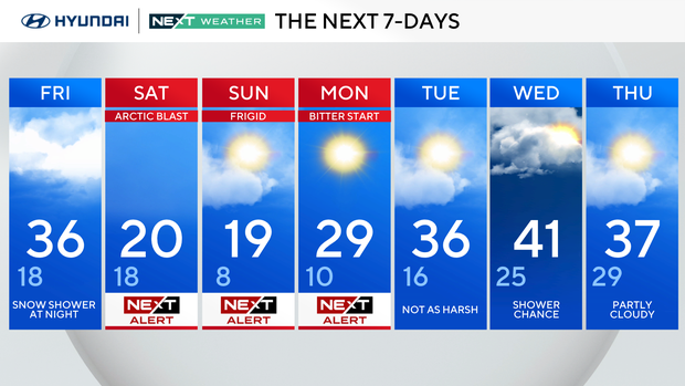
Friday: Snow shower at night. High 36, low 18.
Saturday: NEXT Weather Alert. High 20, low 18.
Sunday: NEXT Weather Alert. High 19, low 8.
Monday: NEXT Weather Alert. High 29, low 10.
Tuesday: Not as harsh. High 36, low 16.
Wednesday: Shower chance. High 41, low 25.
Thursday: Partly cloudy. High 37, low 29.