Tornado watch canceled, but flash flood warnings in effect as severe storms hit Philadelphia region
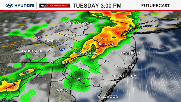
Flash flood warnings are in effect in the Philadelphia region Tuesday evening as multiple rounds of showers and thunderstorms hit the region.
The tornado warning that was in effect in New Castle County in Delaware, Gloucester and Salem counties in New Jersey and Delaware County in Pennsylvania expired at 7:15 p.m. A tornado warning in Chester County expired at 6:45 p.m.
Severe thunderstorm warnings across the region have ended as of 9 p.m. A tornado watch that was in effect across much of the region has been canceled as well.
Flash flood warnings are in effect across the region Tuesday night, including Bucks, Chester, Delaware, Lehigh Montgomery, Northampton and Philadelphia counties in Pennsylvania; New Castle County, Delaware; and Gloucester and Salem counties in New Jersey.
The storms were expected to bring rainfall as heavy as 2 to 3 inches an hour, which is more than enough to cause flash flooding, especially in areas that saw rain on Monday, forecasters said.
When: Through Tuesday night, with impacts lingering into Wednesday morning.
Threats: Damaging wind gusts, torrential rainfall, frequent lightning, localized flash flooding and an isolated tornado cannot be ruled out.
Impacts: Flooded roadways, rapid rises of water in poor drainage and urban areas, significantly reduced visibility, travel delays, isolated power outages from downed trees or limbs and disruptions to outdoor activities.
Charge your devices in case of power outages and plan indoor activities. Also, if you have a sprinkler system for your plants or your lawn, you can shut it off today, as Mother Nature will likely do the job for you.
NEXT big weather changes
Unsettled weather continues Wednesday with scattered showers and thunderstorms as the storm slowly exits the region. While isolated stronger storms remain possible, the overall severe weather threat should gradually decrease through the day.
Humidity will be high most of the week, and unsettled weather will be in the region through Thursday.
Temps will be below normal until Saturday, when the high is expected to be in the mid- to upper-80s.
Friday and Saturday are trending dry, so making weekend plans should be OK.
Next week looks to be much hotter again with the potential for another heat wave. The NEXT Weather Team will keep you posted.
Here's your 7-day forecast:
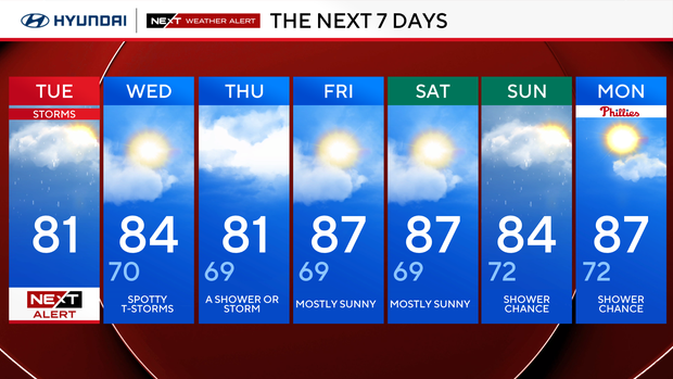
Tuesday: NEXT Weather Alert day for storms. High 81.
Wednesday: Spotty T-storms. High 84, low 70.
Thursday: Shower or storm. High 81, low 69.
Friday: Mostly sunny. High 87, low 69.
Saturday: Mostly sunny. High 87, low 69.
Sunday: Shower chance. High 84, low 72.
Monday: Shower chance. High 87, low 72.


