Drought conditions in Philadelphia region worsen amid recent record-setting warmth. Here's what to know.

After the bitterly cold, gray, and snowy winter the Philadelphia region endured, spring has been the complete opposite with record-setting warmth, sunshine and dry conditions. In fact, it's been more like summer than spring, and that's a problem.
All this pleasantly mild weather has created widespread and worsening drought conditions since the start of what is known as our "Water Year."
The "Water Year" is the 12 months from Oct. 1, when water reserves are typically at their lowest, through Sept. 30 of the following year. This is the timeframe when hydrologists measure the surface water supply, precipitation and streamflow.
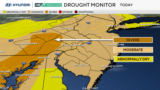
Since Oct. 1, almost all of southeastern Pennsylvania, Southern Jersey and Delaware have gone from no drought conditions to a moderate and severe drought.
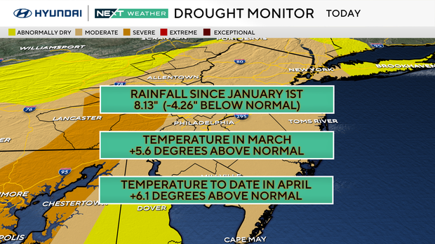
To date, since Jan. 1, we have only received 8.13 inches of precipitation, which is 4.26 inches below the normal expected amount of 12.39 inches.
That leads us back to this very warm spring.
So far, April is a staggering 6.1 degrees above normal, including two rare, record-setting back-to-back 91-degree days. And March was just as warm, at 5.6 degrees above normal, with a pair of record-setting, back-to-back 83-degree days.
Along with the lack of rain, the record heat of the past two months has helped to dry the vegetation and create conditions favorable for wildfires.
One benefit of the recent warmth may be reflected in your recent and upcoming energy bills.
Winter was brutal with extreme electric and gas usage, translating into many more heating degree days (HDD) than normal. And now spring is the opposite, with many fewer than normal heating degree days.
A heating degree day is calculated by taking the difference between 65 degrees and the average daily temperature.
For example, if our average daily temperature is 38 degrees, that day would equal 27 heating degree days. If the average daily temperature is over 65 degrees, there is no heating degree day.
The same formula works for cooling degree days (CDD) in the summer months when the average daily temperature is above 65 degrees.
It's been so warm this spring we have already had over 100 cooling degree days in March and April. Normally, we would have only 10 cooling degree days by now.
Looking ahead, the Climate Prediction Center highlights our area as cooler than normal for the first week of May with near-average precipitation.
That means not enough relief, and the drought conditions will likely continue to worsen.
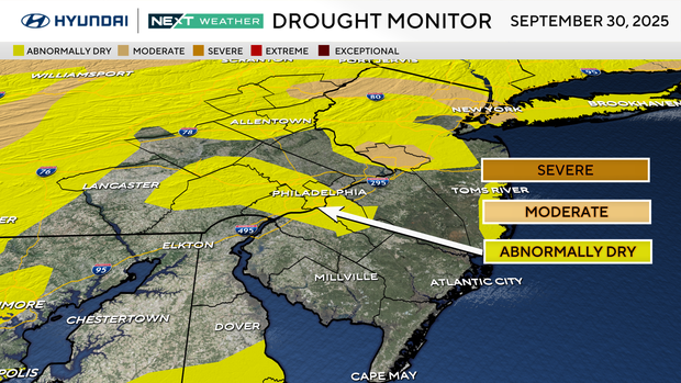
On September 30th, 2025:
Southeastern Pennsylvania, the southern half of New Jersey, and Delaware are virtually drought-free with small areas of ABNORMALLY DRY (yellow) conditions.
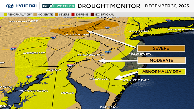
On December 30th, 2025:
Southeastern Pennsylvania, southern New Jersey, and Delaware are now all under ABNORMALLY DRY (yellow) to MODERATE (brown) drought conditions.

On April 21st, 2026:
Southeastern Pennsylvania is under MODERATE (brown) to SEVERE (gold) drought conditions. Notably, the western part of the state is drought-free.
Southern New Jersey is all under MODERATE (brown) conditions. Notably, the entire state is under the same conditions.
Delaware is ABNORMALLY DRY (yellow) for the southern half of the state and MODERATE (brown) drought conditions for New Castle County.


