Temperatures stay below freezing around Philadelphia Sunday, tracking two chances for snow this week


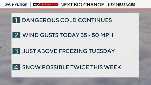
NEXT Weather Alert remains in effect through Monday for bitter cold and wind chills. The big coastal storm delivers coastal flooding risk and very gusty winds to the shore points; a few light snow showers are not out of the question.
A wind advisory is in effect for Cape May County until Sunday at 4 p.m., and Carbon and Monroe Counties until 1 a.m. Monday. A coastal flood advisory is also in effect for Atlantic and Cape May Counties until noon Sunday.
While the strongest gusts from the coastal storm will be along the coast winds in Philadelphia could still gust to 30 mph Sunday, meaning the brutal wind chills will continue through the day, making it likely feel like the single digits despite actual temperatures in the middle 20s.
Deep freeze continues
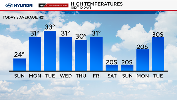
Sunday marks nine consecutive days with a high temperature below freezing, or 32 degrees. The region hasn't seen temperatures above freezing since 7 p.m. on Friday, Jan. 23.
It's the longest subfreezing stretch since 2004 when we had nine days, and only the eighth time Philadelphia has been below freezing for nine or more days. Once we get to Monday (10 days), it will officially be the longest consecutive stretch since 1979, nearly 50 years. Needless to say, temps this cold for this long don't happen too often here in the Philly area!
The only tow other times we saw a stretch of subfreezing temps longer than 10 days was in February 1979 and February 1961, both of which were 15-day stretches.
If temperatures stay below freezing on Tuesday or Wednesday, we might not get above freezing for another week or more, which means we'd break or tie that 15-day record next weekend.
NEXT big weather change
Along with the continuous and possibly record setting stretch of cold days, we are looking at two chances of measurable snow this week.
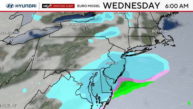
Tuesday night into early Wednesday morning a system just south of the area may lift far enough north to deliver a quick coating to several inches of snow.
Tuesday is also be the best chance of warming above freezing for the first time in over a week. Don't get too excited though, because high temperature will only be around 33 degrees.
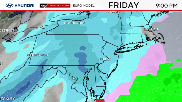
Then Friday evening into early Saturday morning, a clipper system dives out of Canada. It's too early to say if all the pieces will come together, but this could possibly deliver several more inches of snow.
Neither system looks too impressive and certainly not like last weekend, but the NEXT Weather team will continue to monitor the forecast.
Otherwise, the unseasonably cold weather looks to continue for the foreseeable future through next week and beyond.
Here's your 7-day forecast:
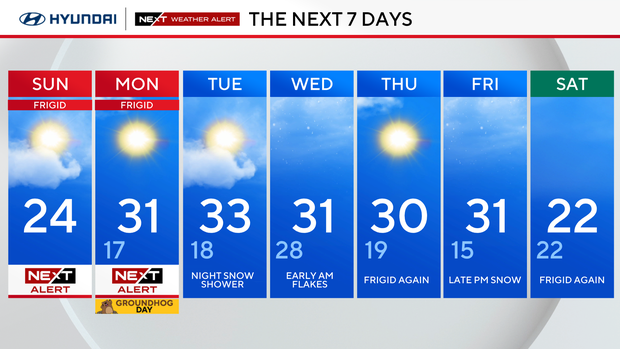
Sunday: NEXT Weather Alert cold and blustery. High 24.
Monday: NEXT Weather Alert. High 31, low 17.
Tuesday: Night snow shower. High 33, low 18.
Wednesday: Early AM flakes. High 31, low 28.
Thursday: Frigid again. High 30, low 19.
Friday: Late PM snow. High 31, low 15.
Saturday: Frigid again. High 22.


