29 states under weather alerts as millions brace for winter storm
A massive winter storm is expected to bring heavy snow and a torrent of rain to most of the northern United States this week, with "extreme impacts" felt across a wide swath of the country, forecasters warned.
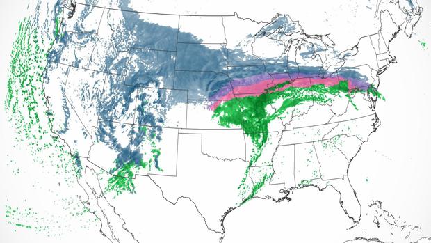
The upper-level pattern will intensify in the coming days as millions of people, from the Pacific Northwest to the Northeast, brace for an oncoming blanket of snow, frozen rain, strong winds and potential flash flooding that prompted winter weather alerts in 29 states, with six states under blizzard warnings. This week's coast-to-coast storm system "will bring numerous weather hazards and significantly anomalous temperatures" stretching from Washington to Maine.
"It will be a long-lasting winter storm with extreme impacts stretching more or less from the West Coast to the East Coast," Chris Warren, a meteorologist and co-host at The Weather Channel, told CBS News in an email. While large coast-to-coast storms, even powerful ones, "are fairly common," Warren noted, "What makes this more unique is the extreme nature of all the possible threats across such a large portion of the United States."
"There will be all types of winter weather," Warren noted. "Heavy snow is expected across several states with strong winds leading to blizzard conditions across parts of the Northern Plains and Midwest."
Particularly severe conditions are expected in some Midwestern states, including Minnesota. Minneapolis is on track for its second-biggest snowfall of all time. Snow emergencies have been declared as double-digit snowfall is expected around the Twin Cities. Travel conditions will be very difficult, if not impossible, around the Midwest, with winds gusting 40-50 mph across Interstates 90, 80, 29 and 35.
Minneapolis Public Schools announced it will close all buildings and move to e-learning for all students for the rest of the week, CBS Minnesota reported. All Minneapolis Public Schools sponsored programs will also be shut down for the week.
That is far from the only place getting an onslaught of winter weather. Roughly a foot of snow is blanketing Salt Lake City, while Denver will likely get 2 to 4 inches, followed by extreme cold temperatures with wind chills dipping to 20 below. Another two feet of snow is expected in the Rocky Mountains.
Heavy ice is anticipated across southern Michigan, including Detroit, which could likely bring traffic to a standstill and cause power outages. As millions braced for potential blackouts, airlines issued travel waivers in anticipation of ongoing flight cancellations and delays.
"Heavy, wet, snow, and freezing rain could lead to scattered power outages from the Great Lakes to the Northeast," said Warren. "Traveling will be extremely dangerous if not impossible in some locations, so it is imperative to listen to local officials before hitting the road."
Different areas of the country are also expected to see record-breaking temperatures — at different ends of the spectrum. As the winter storm calms across the Midwest and Northeast, weather stations east of the Ohio River and across the South are expected to break 90 records for high temperatures Thursday, including in Washington, D.C., which is expected to see 80 degrees Fahrenheit; Orlando, 90 degrees; New Orleans, 83 degrees; Louisville, 77 degrees; and Raleigh, 86 degrees.
Conversely, cities along the West Coast of the U.S. are expected to set records for the coldest high temperatures over the same time period, with a high of 49 degrees expected in Burbank, a high of 48 degrees in San Francisco, a high of 32 degrees in Portland and zero degrees in Billings, Montana.
"Beyond the numerous weather hazards expected this week, another major story will be the significantly anomalous warm temperatures for February over the East and cold temperatures over the West," reads an advisory released by the National Weather Service's Weather Prediction Center, which noted that temperatures highs on Wednesday "will be 20-30 degrees above average for many locations across the Southern Plains, Midwest, and Southeast and 20-30 degrees below average over the Northern/Central Plains and much of the West."
"Many record-tying/breaking highs are possible particularly for the Ohio/Tennessee Valleys, where temperatures will be into the 70s, and closer to the Gulf Coast/Florida, where highs will be into the 80s," the advisory added. "Many record-tying/breaking minimum high temperatures will also be possible over the West, with highs in the 30s and 40s for the Pacific Northwest and in the 50s for California. Bitterly cold wind chills 20-30 degrees below zero are expected for the Northern Plains. These highly anomalous temperatures are forecast to continue later into the week."
Warren said "the main culprit" causing this week's extreme weather pattern "is the strong and vigorous jet stream that will evolve over the next few days across the entire United States."
"It will dive south in the western United States, opening the door for a large arctic air mass from Canada to settle in while at the same time lifting in the east, allowing warmer weather to build across much of the Southern Plains and southeastern United States," the meteorologist said. "The jet stream will also play a key role in driving the storms at the surface across the U.S."