Nate batters Mississippi and Alabama
NEW ORLEANS -- Hurricane Nate brought flooding and power outages as it sloshed ashore outside Biloxi early Sunday, the first hurricane to make landfall in Mississippi since Hurricane Katrina in 2005.
The storm hit the state early Sunday with maximum sustained winds near 85 mph but weakened later to a tropical depression as it moved inland, the U.S. National Hurricane Center said.
As of 11 a.m. EDT, Nate was centered about 40 miles southwest of Montgomery, Alabama, with maximum sustained winds of 35 mph.
Authorities were beginning to assess the storm's impacts, but most areas in Nate's path seem to have avoided major damage - including New Orleans.
At one point, Nate's eye move over Keesler Air Force Base, where the National Hurricane Center's hurricane hunter planes are kept, the center said.
It was Nate's second landfall. Saturday night, the storm came ashore along a sparsely populated area in southeast Louisiana.
Nate's powerful winds pushed water onto roads and its winds knocked out power to homes and business. But Nate didn't have the intensity other storms - Harvey, Irma and Jose - had during this busy hurricane season, and people didn't seem as threatened by it. No deaths or injuries were immediately reported.
Nate's powerful winds have knocked out power to more than 100,000 customers in Mississippi and Alabama. More than 25,000 power outages were reported in southern Mississippi, according to CBS affiliate WLOX. Outages were mostly concentrated on the eastern half of the state's narrow coastal strip, in Harrison, Jackson and George counties.
More than 70,000 people were without power in Alabama early Sunday morning.
Follow along with the latest updates below. All times are Eastern unless otherwise noted.
3:55 p.m.: Trump: Response to Nate "under control"
On Sunday afternoon, President Trump tweeted that FEMA and first responders are "working hard (yet again) on Hurricane Nate."
2:10 p.m.: Mississippi reopens casinos after storm
Mississippi Gulf Coast casinos have been given the all-clear to reopen while the region recovers from Hurricane Nate.
The Mississippi Gaming Commission said on its website that coastal casinos were allowed to re-open as of 11:30 a.m. Sunday.
Closures were ordered Saturday as Nate approached.
The storm hit the coast with surges of up to 10 feet, and some casinos reported ground level flooding.
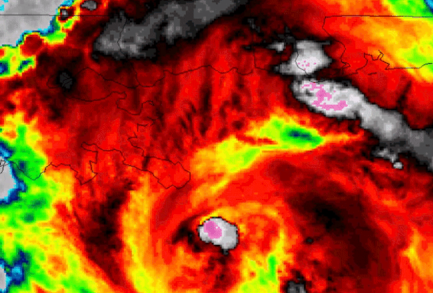
Nate was a Category 1 hurricane when it came ashore outside Biloxi early Sunday. By midday Sunday, the National Hurricane Center in Miami had downgraded Nate to a tropical depression.
11:20 a.m.: FEMA chief says storms have "strained" resources
The head of the Federal Emergency Management Agency said the hurricanes that have struck the U.S. and its territories this year - four so far - have "strained" resources. FEMA Administrator Brock Long told ABC's "This Week" that some 85 percent of the agency's forces were deployed and still working on issues created by hurricanes Harvey, Irma, Maria and now Nate.
He said that "in regards to resources, of course we're strained" because "nearly 85 percent of my entire agency is deployed right now. We're still working massive issues in Harvey, Irma, as well as the issues in Puerto Rico and the Virgin Islands, and now this one."
8:28 a.m.: Nate "rapidly weakening"
Tropical Storm Nate's maximum sustained winds dropped to 45 miles per hour, the National Hurricane Center said on Sunday morning, a few hours after it swept ashore in Mississippi as a hurricane. The storm was "rapidly weakening," the center said in an advisory, which said heavy rains and storm surge flooding continued in the region.
7:15 a.m.: Nate brings storm surge
As the midnight high tide approached in Biloxi, a storm surge from Nate pushed over the beachfront highway of U.S. 90 onto the peninsula that makes up the city's eastern edge. It flooded the parking structure of the Golden Nugget casino, which is closest to the peninsula's tip. Water kept going several blocks deep into the area.
"It kind of surprised us," Mike Kovacevich, who lives two blocks north of U.S. 90, told Biloxi officials on their Facebook page. "We didn't expect to be this deep. It come in pretty good - a lot of water."
The city of Biloxi posted video of the storm surge on Facebook:
Pascagoula also reported that storm surge flooded downtown streets in that coastal city.
3:55 a.m.: Nate weakens to a tropical storm
Nate weakened to a tropical storm as it moves inland over Mississippi and Alabama. The U.S. National Hurricane Center says the storm is expected to continue quickly weakening.
1:55 a.m.: Nate makes second landfall near Biloxi
Hurricane Nate made second landfall near Biloxi, Mississippi as a Category 1 storm, the National Hurricane Center said. The storm has maximum sustained winds of 85 mph.
A hurricane warning is in effect from the mouth of the Pearl River to the Alabama/Florida border.
A turn toward the north-northeast and northeast with an increase in forward speed is expected during the next couple of days, the National Hurricane Center said. On the forecast track, Nate's center will continue to move inland over Mississippi and across the Deep South, Tennessee Valley, and central Appalachian Mountains through Monday.
1:44 a.m.: More than 17,000 without power in Mississippi
As of 1 a.m. ET Sunday, roughly 17,000 customers from multiple utility companies are without power, CBS affiliate WLOX reports.
1:15 a.m.: Social media images show storm surge washing ashore
Photos and videos from social media early Sunday showed the storm surge washing ashore along the Gulf Coast in Mississippi and Alabama.
The National Weather Center has warned that life-threatening storm surge from the mouth of the Mississippi River to the Okaloosa/Walton county line in Florida.
12:30 a.m.: Nearly 3,500 power outages reported in Mississippi
Nearly 3,500 people from multiple utility companies were without power as of 11 p.m., reported CBS Biloxi affiliate WLOX.
The storm is expected to make second landfall near Biloxi. As of 11 p.m., the National Hurricane Center said Nate was about 35 miles (56 kilometers) south of Biloxi. After that, the center of the storm will move across the Deep South, Tennessee Valley and central Appalachian Mountains through Monday.
11:54 p.m.: Nate's northern eyewall moving onto Mississippi shore
Nate's northern eyewall, the most dangerous part of the storm, is moving onshore on the Mississippi coast, said the National Hurricane Center.
Hurricane conditions are spreading on the coasts in Mississippi and Alabama, the National Hurricane Cetner said. Life-threatening storm surge is expected from the mouth of the Mississippi River to the Okaloosa/Walton county line in Florida.
9:36 p.m.: New Orleans mayor lifts curfew
New Orleans mayor Mitch Landrieu lifted the city's curfew after the National Weather Service lifted the hurricane warning for the city.
Landrieu's office recommended that people continue to shelter in place.
CBS News' weather producer David Parkinson reported New Orleans will get the weaker end of the storm, but the city could still face wind gusts as high as 55 mph, Parkinson said.
9:22 p.m.: Storm surge could reach 11 feet in some areas
Hurricane Nate made its first landfall on the Louisiana coast and is expected to make landfall around midnight on the Mississippi coast, CBS News weather producer David Parkinson reports.
Storm surge will be a real threat from Pensacola Beach through Dauphin Island and along the entire Mississippi Gulf Coast. Surge of 7 to 11 feet is expected from Waveland, Mississippi to the state's border with Alabama, and surge of 6 to 9 feet is expected in Mobile Bay.
In terms of New Orleans, while it is possible power goes out, the city is on the weaker side of the storm so even if they get 3 inches of rain, there shouldn't be widespread flooding. Major surge isn't expected there as they are protected by a levee. Four to seven feet of surge is possible on the north end of Lake Pontchartrain. The impact zone for this storm is Mississippi Gulf Coast, Alabama Gulf Coast and western Florida panhandle Gulf Coast.
Wind from the storm is expected to be 90 mph, with some wind gusts up to 100 mph. The primary threat from the storm is storm surge, Parkinson reports.
8:05 p.m.: Nate makes landfall near the mouth of Mississippi River
Hurricane Nate made landfall near the mouth of the Mississippi River as a Category 1 storm with winds of 85 mph, the National Hurricane Center said.
As of 8 p.m., the storm is located about 100 miles south of Biloxi, Mississippi.
The National Hurricane Center said Saturday night that Nate is expected to make a second landfall along the coast of Mississippi on Saturday night and then pass over parts of Mississippi, Alabama and Tennessee.