Hurricane Lee's path and timeline: Meteorologists project when and where the storm will hit
Update: Lee made landfall in Canada.
Former Hurricane Lee was lashing New England and southeastern Canada on Saturday after it became a post-tropical cyclone. Watches and warnings are up for the coastal areas of Maine, New Hampshire and the Canadian Maritime Provinces of New Brunswick, Nova Scotia and Prince Edward Island.
Lee's effects were already being felt along the southeast U.S. coastline, and forecasters said Lee would make its presence felt with "hazardous surf and rip current conditions" at beaches along the western Atlantic all week.
Lee rapidly intensified over the Atlantic Ocean's very warm waters late last week, swelling into a powerful Category 5 hurricane before its wind speeds started to decline.
Where is Lee heading?
As of 2 p.m. EDT on Saturday, Lee had maximum sustained winds of 70 mph, according to the National Hurricane Center.
Hurricane-force winds were extending up to 140 miles from the center of Lee and tropical-storm-force winds were extending up to 390 miles from the center. The center of the storm was about 80 miles south-southeast of Eastport, Maine, and about 150 miles west-southwest of Halifax, Nova Scotia, according to the hurricane center. Lee was moving north at 22 mph.
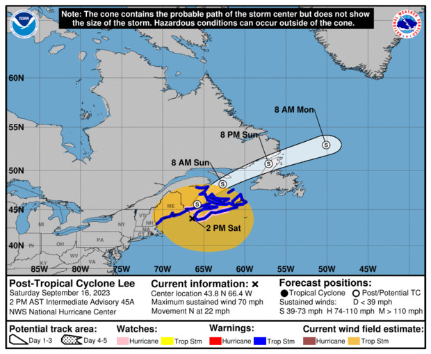
"The center of Lee is forecast to make landfall in Atlantic Canada later this afternoon," the hurricane center wrote. "Lee is then expected to turn toward the northeast and move across Atlantic Canada tonight and Sunday."
A hurricane watch is in effect for parts of southeastern Canada.
A tropical storm warning was in effect from Portsmouth, New Hampshire, north to the U.S.-Canada border and parts of southeastern Canada.
Where will Lee make landfall?
According to the hurricane center, Lee is expected to make landfall in southeastern Canada on Saturday.
CBS Boston meteorologists reported Friday with "high confidence" that the center of Lee is expected to pass about 200 miles east of southern New England Saturday morning, likely as a minimal Category 1 hurricane, transitioning to an extra-tropical, nor'easter-type storm.
President Biden issued an emergency declaration for the state of Maine late Thursday, ahead of the Lee's arrival, that will free up resources from the Federal Emergency Management Agency "to coordinate all disaster relief efforts."
Will Hurricane Lee hit Massachusetts?
Lee is expected to move up the coast of Massachusetts without making landfall in the state — but coastal areas will feel the effects of the storm.
CBS Boston reported the "greatest impact will be felt on the Lower and Outer Cape and on Nantucket."
"If you live on the Cape of Massachusetts or Maine, keep a close eye on Lee as we head into the weekend," Weather Channel meteorologist Stephane Abrams said Tuesday on "CBS Mornings."
"The exact positioning of the storm and level of impacts we'll see in the U.S. will be determined in part by high pressure off to the east and a trough off to the west," she said. "If Lee ends up farther west, we could have stronger winds, heavier rain, larger swells and coastal flooding. If it slides more east, the impacts would be less intense."
Inland areas, away from the coast, are expected to see very little rain and just some gusty wind, the station reported.
Will Hurricane Lee hit New York?
New York is not expected to take a direct hit, but CBS New York reports Long Island shore towns are preparing for potential effects from the storm. High surf, dangerous rip currents and beach erosion are likely to be the biggest threats there.
"We've had crews for the last week, and they will be out all weekend long securing these waterways, building up these areas to try and preserve our beaches," Hempstead Town Supervisor Don Clavin told the station.
Gov. Kathy Hochul also deployed 50 National Guard members to Long Island to help prepare for the storm.
Hurricane Lee spaghetti models
Spaghetti weather models, or spaghetti plots, are computer models showing the possible paths a storm may take as it develops. These models don't predict the impact or when a storm may hit, according to the Weather Channel, but focus on showing which areas might potentially be at risk.
Spaghetti models for Hurricane Lee mostly showed the storm traveling over the Atlantic as it heads northward, closing the gap near northern New England. A spaghetti model for Lee created Tuesday, seen below, showed most projected paths skirting along the U.S. coast at least up to New England, with a potential impact along the northern New England coast or Canadian Maritimes late this week.
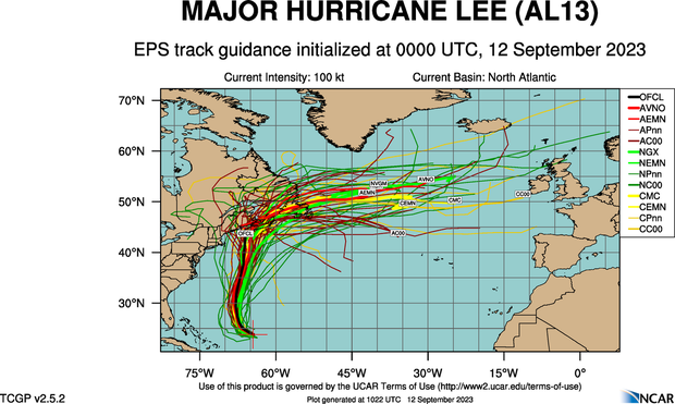
Another set was posted by The Weather Channel's Jim Cantore Monday, who wrote: "Recent trends from model guidance have brought #Lee back west enough so that it has put southeastern New England in the NHC track cone. It should be noted that track guidance can error by hundreds of miles for this time out 5-6 days. That said, Lee will likely be an expanding…"
What are the hurricane category wind speeds?
Hurricanes are rated on the Saffir-Simpson Hurricane Wind Scale, which includes five categories based on the storm's sustained wind speeds. Here is a look at how the categories break down and how the National Hurricane Center describes the potential level of damage such storms can cause if they make landfall:
Category 1: Sustained wind speed of 74-95 mph
"Very dangerous winds will produce some damage"
Category 2: Sustained wind speed of 96-110 mph
"Extremely dangerous winds will cause extensive damage"
Category 3: Sustained wind speed of 111-129 mph
"Devastating damage will occur"
Category 4: Sustained wind speed of 130-156 mph
"Catastrophic damage will occur"
Category 5: Sustained wind speed of 157 mph or higher
"Catastrophic damage will occur"
Any storm of Category 3 or higher is considered a "major hurricane" with the potential for "significant loss of life and damage."