Lee expected to be "near hurricane strength" when it makes landfall later today, forecasters say
Update: Lee made landfall in Canada.
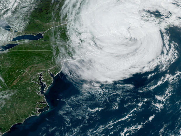
Former Hurricane Lee is lashing eastern New England and southeast Canada and is expected to make landfall Saturday, forecasters said. As the storm approached Nova Scotia, it became a post-tropical cyclone but it is expected to be "near hurricane strength" when it makes landfall in southeastern Canada, the National Hurricane Center said Saturday.
The storm was a Category 1 hurricane on Friday and at one point last week had Category 5 strength.
CBS News senior weather and climate producer David Parkinson said the Canadian Maritime Provinces of Nova Scotia, New Brunswick and Prince Edward Island were going to experience the worst effects from Lee. The hurricane center expected Maine's coast would experience tropical storm conditions and coastal flooding as well.

In New England, Lee was expected to drop 1-4 inches of rain in eastern Maine and far eastern Massachusetts, according to the hurricane center. Coastal areas of Maine could see 20-foot waves, and parts of the Massachusetts coast could see 15-foot waves, Parkinson said.
"This is as good as you're going to get with a hurricane coming this close to New England," Parkinson said.
President Biden issued an emergency declaration for the state of Maine late Thursday, ahead of the Lee's arrival, that will free up resources from the Federal Emergency Management Agency "to coordinate all disaster relief efforts."
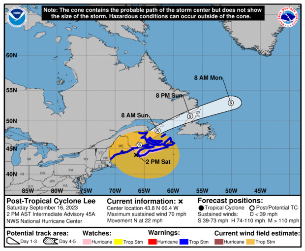
As of 2 p.m. EDT on Saturday, Lee had maximum sustained winds of 70 mph, according to the hurricane center.
Hurricane-force winds were extending up to 140 miles from the center of Lee and tropical-storm-force winds were extending up to 390 miles from the center.
Lee's "cone of uncertainty"
The hurricane center releases forecast cones for tropical cyclones showing the probable path for a storm's center. The forecast cone is sometimes called the "cone of uncertainty" because the storm's center historically moves outside of the probable path "about a third of the time," according to the center. Officials urge people to not focus entirely on a storm's center because its effects can be felt hundreds of miles away.
Where is Lee?
The center of the storm was about 80 miles south-southeast of Eastport, Maine, and about 150 miles west-southwest of Halifax, Nova Scotia, according to the hurricane center. Lee was moving north at 22 mph.
Ahead of the storm, a hurricane watch was in effect for parts of southeastern Canada. The watch means hurricane conditions are possible for the area. Earlier, Lee prompted a hurricane watch to be issued in Maine for the first time since 2008, Parkinson reported.
A tropical storm warning was issued from Portsmouth, New Hampshire, northward to the U.S.-Canada border and parts of southeastern Canada. The warning means tropical storm conditions are expected in the area through Sunday.