How much rain did Minnesota get during latest storm? Rainfall totals from across the state
MINNEAPOLIS — Minnesota's latest round of storms poured heavy rain on Minneapolis and other parts of the state for hours on Tuesday.
The map below shows the National Weather Service's rainfall totals as of 11 a.m. on Wednesday.
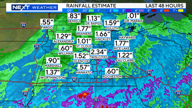
The Twin Cities saw the most rain, with 2.34 inches recorded. Up north, Duluth got 1.59 inches, Brainerd 1.77 and Hinckley 1.66. In southwestern Minnesota, Worthington saw 1.37 inches fall. On the opposite end of southern Minnesota, Rochester got less than an inch.
The rainfall total recorded at Minneapolis-St. Paul International Airport made Tuesday the wettest day since June 29, 2020 — nearly four years ago.
WCCO's NEXT Weather Watchers across the state are also reporting rainfall totals.
In Minneapolis, most reported totals in the 1-2 inch range, though some reported as much as 3-4 inches.
Up north, near Clear Lake, Linda Conner reported 3 inches of rain. Further east, Bob Connelly in Cohasset — near Grand Rapids — logged 1.7 inches.
Out west in Ortonville, Margaret Adelman registered 2.3 inches.
In southern Minnesota, Jared Turbes of Winnebago measured 2 inches of rain, while Sandy Grove in Windom saw 1.7.
Our next shot at rain will come Friday, and more showers are possible Sunday and Monday, as well.
Minnesota's drought conditions have improved greatly thanks to recent bouts of rainfall. As of the latest drought report, released last Thursday, no parts of the state are experiencing severe drought and nearly three-quarters of the state isn't experiencing any degree of drought.


