Will Hurricane Erin impact South Florida? Here's the system's projected path.
For the latest on Hurricane Erin and indirect impacts to South Florida, click here.
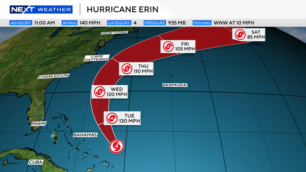
After rapidly intensifying into a Category 5 storm on Saturday, Hurricane Erin has since been downgraded to a Category 4 system with sustained winds of 140 mph.
The big question for many people across South Florida and the eastern coast of the United States is, "Will we see impacts?"
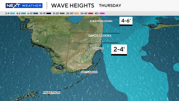
Hurricane Erin is expected to continue to moving west-northwest through the Atlantic just north of the Turks and Caicos Islands and the Eastern Bahamas. Even the though the storm is expected to track between the Carolinas and Bermuda by the middle of the week, hazardous surf conditions will develop along the Mid-Atlantic States. Later this week the swells from the large hurricane will travel down the Florida coastline. Surf is expected to increase Thursday and Friday with 2-4 foot waves in South Florida.
No direct U.S. impacts expected; monitoring continues
As of the latest update from the National Hurricane Center, no direct impacts are expected in the U.S. Indirect impacts such as rough marine conditions and elevated rip current risk will be possible along the east coast for the first half of next week. The NEXT Weather Team is continuing to monitor all updates.
The storm looks better organized and is forecast to intensify Monday but at the same time continue the turn to the north.
The outer bands of Hurricane Erin will produce areas of heavy rainfall across portions of Hispaniola on Monday and through Tuesday for the Turks and Caicos and the southeastern Bahamas. Additional rainfall totals of 2 to 4 inches with isolated higher amounts of 6 inches possible.
This forecast track will keep the center of Erin east of the Bahamas and on a track to pass between the Outer Banks on Wednesday. The forecast cone remains over open water but, given the increasing size of Erin's wind field, a slight westward movement may bring tropical storm conditions near the Mid-Atlantic states. Later this week the track continues to curve to the northeast keeping the storm over the Atlantic while it accelerates into the North Atlantic.
Erin expected to turn north
Overnight Monday in early Tuesday, the storm will be directly east of South Florida as it turns north.There will be a break in the ridge of high pressure, which has been steering the storm west-northwest, which will lead to a track between the Carolinas and Bermuda on Wednesday.
When it starts to turn northward, Erin will send waves towards the southeastern Atlantic coastline, including the Florida coast. Southeastern Florida can expect increased wave heights on Wednesday and Thursday of 2 to 4 feet. This will also create a rip current risk.
High surf advisories are already in effect to much of the Eastern U.S. coastline and are likely to extend south into portions of the Florida Peninsula. While South Florida is protected from the swells and higher surf generated by Erin from the Bahamas, there will be a point when the storm is far enough north where these waves can work down the Florida coastline. This will be mainly Wednesday and Thursday and may require marine and surf advisories. Stay tuned to the forecast updates throughout the week.
The storm is then forecast to accelerate and turn northeast, staying off the coast of Canada onThursday and Friday. The main concern along the East Coast is the storm's size expanding. A slight shift in the track to the west may bring strong wind gusts to the Outer Banks and other Mid-Atlantic States.
The NEXT Weather team will continue to monitor updates from the NHC and track the latest model trends.