Another steamy day in store for South Florida with triple-digit feels-like temperatures possible

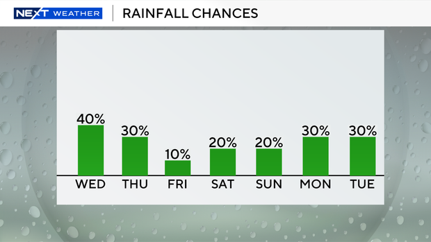
Another round of wet weather is expected across South Florida on Wednesday, but it won't be as widespread as yesterday.
It also wasn't quite as warm during the morning hours as it was on Tuesday morning, with people waking up Wednesday with temperatures in the mid- to upper 70s.
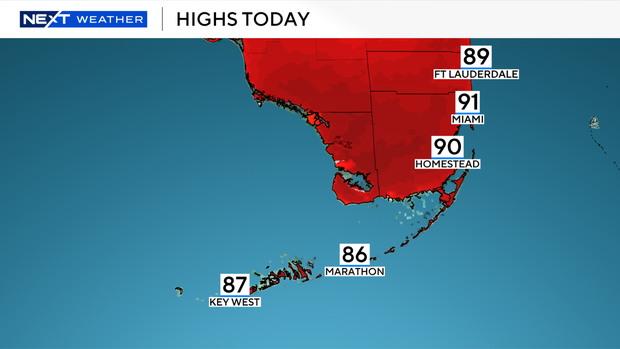
It will be another hot and humid afternoon with temperatures climbing into the low 90s. And when you factor in the humidity, it will feel like the upper 90s and into the triple-digits.
There is a minor to moderate risk of heat-related illnesses on Wednesday, which means that the heat could impact people who are sensitive to heat.
It will be important to stay hydrated and stay in the shade or air conditioning during the hot afternoon hours to avoid heat exhaustion.
The rain will roll in during the afternoon and evening hours and will provide some relief and help with the brushfires.
Scattered showers and thunderstorms will be possible on Wednesday due to a warm front draped across North Florida and a low pressure system in the Gulf that's pumping in plenty of moisture.
The Storm prediction Center has not placed South Florida under a risk of severe weather, but a few heavy downpours, gusty winds and lightning will be possible with some of the storms later on.
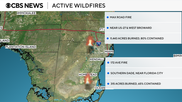
The rain on Tuesday helped with improving containment of fires burning in western Broward and southern Miami-Dade counties.
The Max Road Fire west of US-27 in Broward is now 80% contained but has burned about 11,443 acres. The 172 Avenue Fire near Florida City in southern Miami-Dade is now 65% contained and has burned about 315 acres.
The winds will be out of the west and southwest on Wednesday and that could steer any lingering smoke towards portions of inland and metro areas.
Skies may appear to be hazy in spots due to the smoke, and air quality is good as of Wednesday morning in Broward and Miami-Dade.
There is a low risk of rip currents if you're headed to the Atlantic beaches on Wednesday. Small craft should exercise caution over the Atlantic waters, but there are no alerts or advisories for boaters over the Keys waters.
The chance of rain will decrease a bit on Thursday with spotty storms around. High temperatures will remain above average near 90 degrees.
Rain season begins on Friday, but we'll enjoy a drier day with very low rain chances. Isolated showers will be possible with plenty of sunshine.
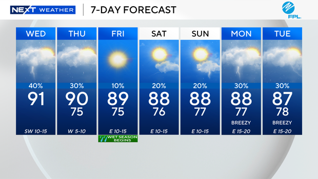
High temperatures will rise into the upper 80s.
This weekend we can expect a few showers and spotty storms with high temperatures continuing in the upper 80s. The breeze will begin to build early next week.