More dangerous heat expected in South Florida ahead of NEXT Weather Alert day Thursday

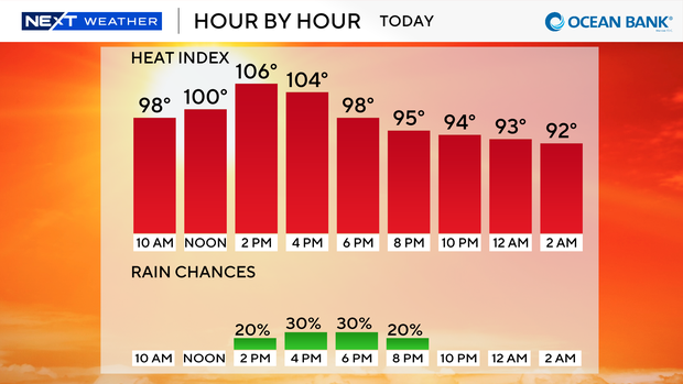
Another heat advisory has been issued on Wednesday for Broward and Miami-Dade counties from 12 p.m. until 6 p.m. due to the feels-like temperatures that could reach up to 108 degrees when you factor in the humidity.
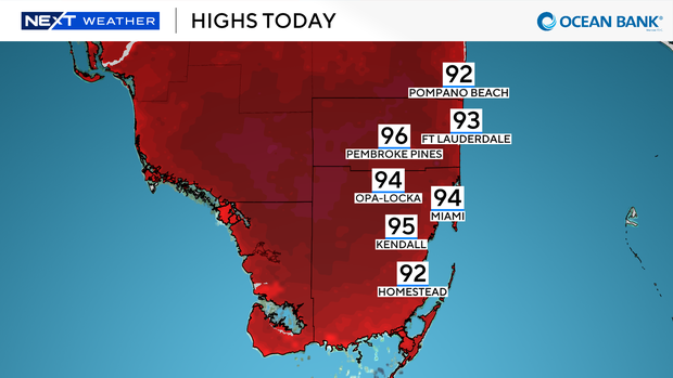
Record heat will be possible on Wednesday as high temperatures soar to the low to mid-90s during the afternoon.
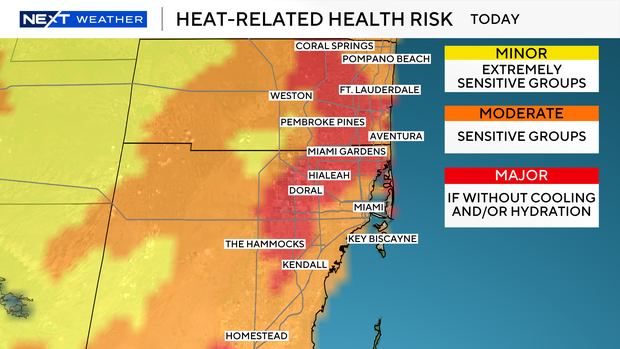
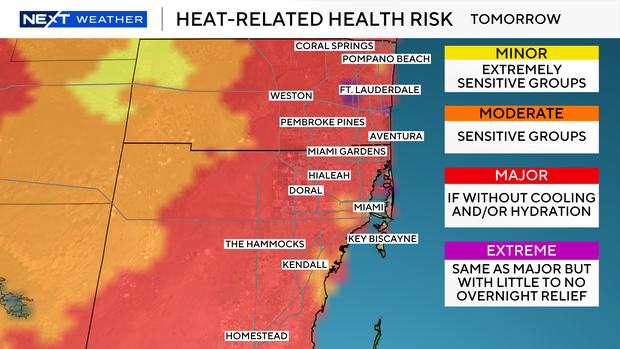
There is a moderate to major risk of heat-released illnesses for sensitive groups and for those who do not properly cool and/or hydrate.
We will enjoy mainly dry conditions to start the day, but later Wednesday afternoon and evening some showers and thunderstorms will move in.
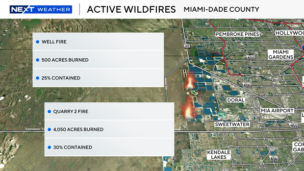
We need the rain to bring relief from the extreme heat and to help crews battling two wildfires in western Miami-Dade.
The two wildfires in Miami-Dade are leading to some haze, lower air quality and reduced visibility in some spots.
The Quarry 2 Fire is located near Northwest 137th Avenue and Northwest 25th Street and has burned 4,050 acres and is 30% contained. The second fire, the Well Fire, has burned 500 acres and is 25% contained.
The wind will increase out of the south and southwest later Wednesday that will likely steer smoke from the fires toward the north then the northeast and potentially eastward later.
Air quality is currently moderate for Broward and Miami-Dade. Residents with respiratory conditions in the area are advised to stay indoors and recirculate the air from air conditioners.
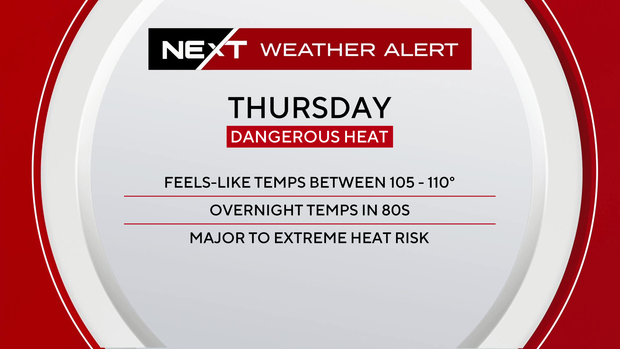
The CBS News Miami NEXT Weather team is issuing a NEXT Weather Alert tomorrow, Thursday, due to dangerous heat indices that could reach up to 110 degrees, and because we will have a major to extreme risk of heat-related health illness.
This extreme risk is the same as major, but with little to no relief overnight due to lows will staying warm in the 80s.
Highs will climb to the low to mid 90s and it will feel like the triple-digits.
Some heat safety tips include staying hydrated, limiting strenuous activities during the afternoon hours, wearing light-colored and loose-fitting clothing and staying in the air-conditioning and shade as much as possible
Tomorrow will be mostly dry with just a few showers possible.
The sizzling heat sticks around Friday for Juneteenth as highs remain in the low 90s and feels like temperatures continue in the 100s.
Spotty storms will be possible.
The chance of rain rises this weekend with scattered showers and storms likely on Saturday and Sunday for Father's Day.
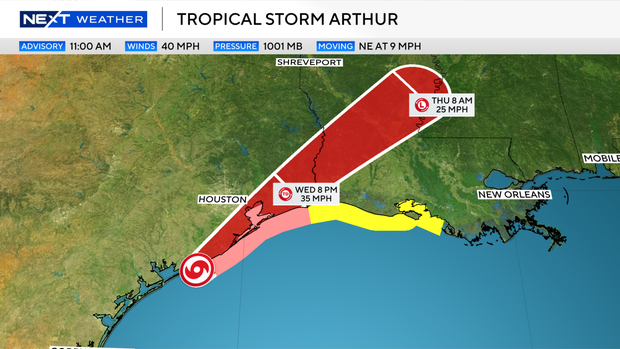
The first named storm of the 2026 Atlantic hurricane season has formed – Potential Tropical Cyclone One is now Tropical Storm Arthur.
Arthur is not a threat to South Florida, but life-threatening flooding is expected across the southeastern U.S.
Arthur is located 40 miles east-northeast of Port O Connor, Texas, with maximum sustained winds of 40 miles per hour. It is moving to the northeast at 9 miles per hour.

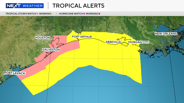
A tropical storm warning is in effect for High Island, Texas, to Morgan City, Louisiana.
A tropical storm watch is in effect for Sargent, Texas, to High Island, Texas.
Arthur is expected to move northeastward along the Texas coast today and then move inland over southwestern Louisiana tonight.
Weakening is anticipated once it moves inland and it could dissipate by tonight or early Thursday.
Tropical Storm Arthur is expected to produce rainfall of 5 to 10 inches with isolated higher totals near 20 inches through early Friday from the Mid and Upper Texas coast east-northeast into southern and central portions of Louisiana, Mississippi, and Alabama, along with western portions of Georgia and the Florida Panhandle.
This could produce life-threatening flash flooding.
A couple of tornadoes will be possible along the Gulf coast and southeast U.S.