South Florida to see more rounds of showers, storms ahead of sizzling warmup later this week

After a stormy start to the new workweek, parts of South Florida are expected to see additional rounds of showers and thunderstorms on Tuesday.
The CBS News Miami NEXT Weather team was busy tracking some showers across the Florida Keys earlier on Tuesday morning.
As temperatures climb into the low 90s later Tuesday afternoon, storms will likely fire up across Miami-Dade and Broward due to the heating of the day, lingering moisture and a westerly steering flow.
Some of the thunderstorms that develop could produce lightning, gusty winds, heavy downpours and localized flooding.
There's a low risk of rip currents along the Atlantic beaches and the UV index is extreme.
There are no alerts in effect for boaters over the Atlantic waters or Keys waters.
The chance of rain is lower mid- to late week due to drier air on the way. On Wednesday, the breeze builds out of the southwest at 10 to 15 mph with gusts as high as 20 mph possible.
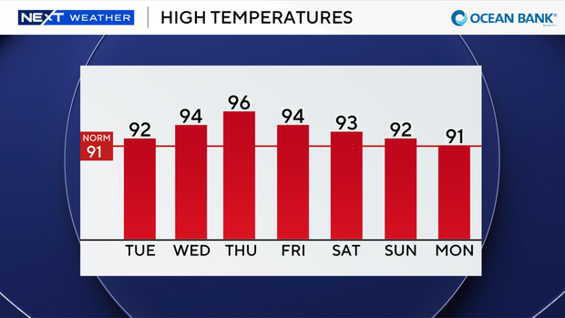
Although spotty storms will be possible, the weather headline will be the potential for near-record heat as high temperatures soar to the low to mid 90s.
When you factor in the humidity, it will feel like the triple digits.
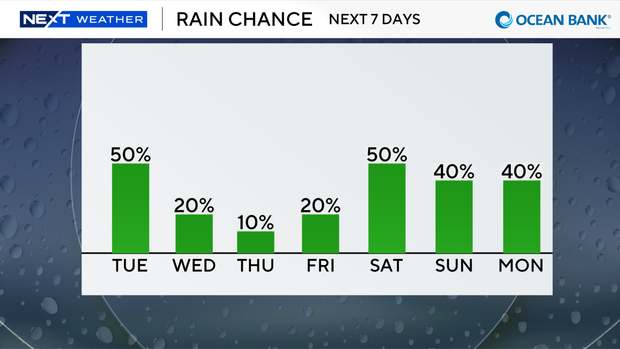
It will be even drier on Thursday with only a few stray showers possible. We'll enjoy mostly sunny skies and the southwest breeze will continue.
Thursday will also likely be the hottest day of the week as highs soar to the mid to upper 90s. It will be a scorcher.
South Florida will still be sizzling and flirting with record heat on Friday with highs in the low to mid 90s. A few storms will be possible.
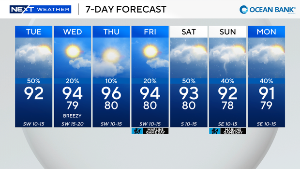
This weekend, the rain chance increases a bit with the potential for passing storms on Saturday and Sunday due to a surge of moisture.
Saharan dust is also expected to move in and possibly lead to hazy skies and lower air quality. Highs will be closer to normal in the low 90s this weekend.