Hot and humid for South Florida on Sunday with pop-up rain


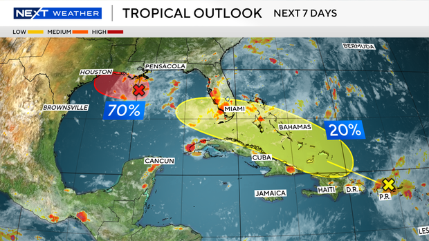
The NEXT Weather Team is tracking the tropics this week as two systems. An area of low pressure in the Gulf and the remnants of Dolly are moving through the Caribbean near Puerto Rico Sunday night.
The National Hurricane Center's outlook now gives an area of low pressure in the northern Gulf, known as AL97, a 70% chance of development over both the next 48 hours and the next seven days, up from 50% earlier Sunday.
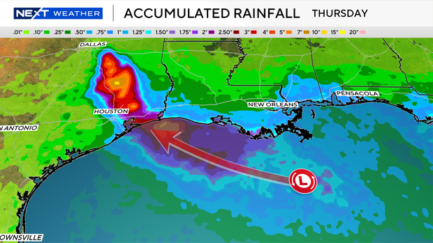
The system was located about 125 miles south of the Louisiana coast Sunday evening and has grown better organized. A short-lived tropical depression or tropical storm could form before the system reaches the Upper Texas or southwestern Louisiana coast Tuesday or Tuesday night.
An Air Force Reserve reconnaissance aircraft, call sign Teal 71, is scheduled to fly into the system starting at 8:30 a.m. Monday to gather data on its structure.
Regardless of whether the system develops, locally heavy rainfall is expected along the Upper Texas and southwestern Louisiana coasts over the next several days, with the potential for flooding around the Houston area and points along Interstate 10.
Farther east, the remnants of what was Tropical Storm Dolly are producing heavy rain, gusty winds and dangerous surf across Puerto Rico and the U.S. Virgin Islands.
The National Weather Service in San Juan has issued a high risk of rip currents through Monday afternoon for beaches across Puerto Rico and the Virgin Islands, along with a small craft advisory through midday Monday because of hazardous seas.
The hurricane center's outlook puts the system's chance of redeveloping into a tropical cyclone at near 0% through 48 hours and 20% through seven days as it tracks toward Hispaniola and eastern Cuba over the next two days.
By the middle of the week, regardless of redevelopment, tropical moisture will be moving through South Florida. Rain chances will increase along with the potential for minor flooding with heavier downpours.
The Next Weather team will continue tracking both systems and provide updates as new forecasts and outlooks are issued.