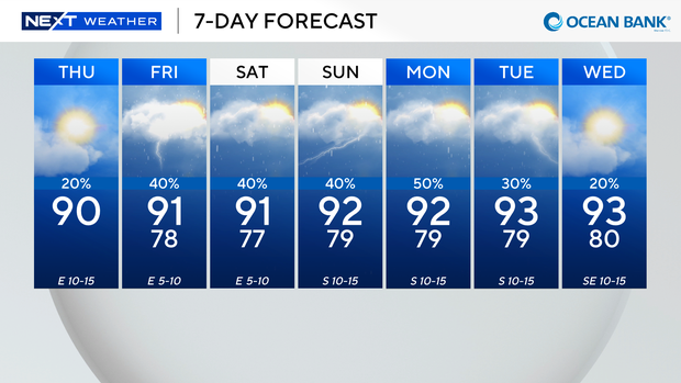
Temperatures in South Florida to rise into low 90s on Thursday after comfortable start to the day

It wasn't as warm in South Florida on Thursday morning as we woke up to temperatures about two to eight degrees cooler than Wednesday morning.
Some inland areas enjoyed temperatures in the low 70s while the rest of South Florida woke up to temperatures in the upper 70s and low 80s.
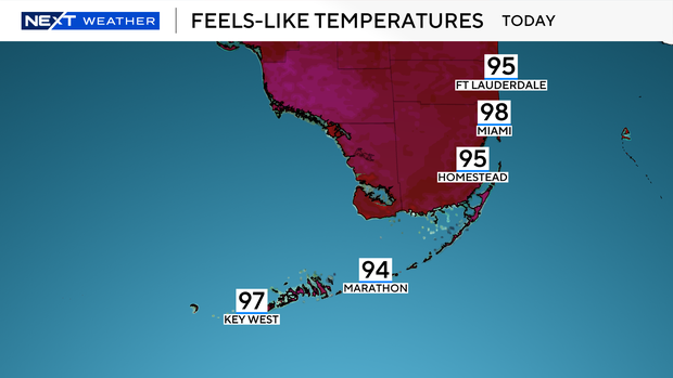
Enjoy the comfortable start since we will be heating up to around 90 degrees on Thursday afternoon, and it will feel like it's in the mid- to upper 90s when you factor in the humidity.
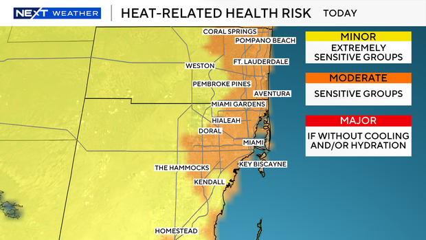
There is a moderate risk for heat-related illness on Thursday for sensitive groups.
Hydration is key to avoid heat exhaustion and heat illness.
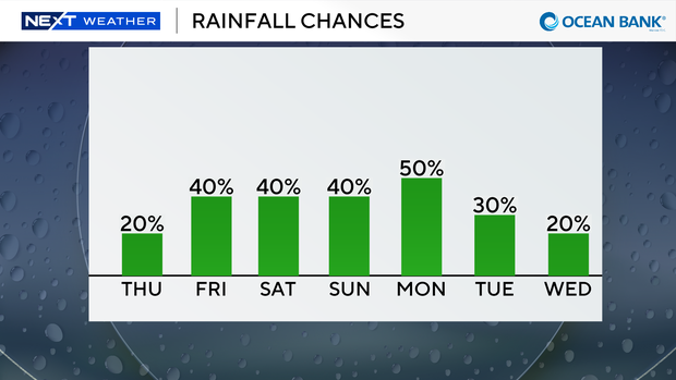
It has been mainly dry on Thursday morning, but some showers are possible later in the days. Most of the storms will be steered inland towards the Florida Everglades and west coast due to the east breeze.
There is only a low risk of rip currents but the UV index is extreme. There are no alerts or advisories for boaters along the Atlantic waters and Keys waters.
The chance of rain rises again on Friday through the weekend. It will not be a washout but scattered showers and thunderstorms will develop due to plenty of moisture moving in.
High temperatures will be in the low 90s on Friday, Saturday and Sunday.
An upper-level low will develop bear eastern Cuba the second half of the weekend and will likely meander into the region well into next week.
It's too soon to say if the moisture associated with this low-pressure system will enhance moisture for South Florida, but we will be keeping an eye on this over the next few days.
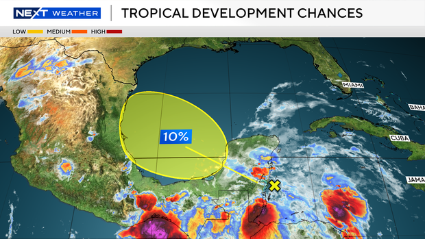
The CBS News Miami NEXT Weather team is also monitoring an area in the tropics. The National Hurricane Center said a broad area of low pressure is likely to form over the Bay of Campeche on Friday from a westward-moving tropical wave currently located over the Yucatan Peninsula of Mexico.
The National Hurricane Center is giving the system a 10% chance of development over the next two to seven days as environmental conditions are forecast to be only marginally conducive for development before the system moves inland over easter Mexico late Saturday or Sunday.