South Florida faces triple threat of dangerous heat, flooding rains and wildfire smoke this week

South Florida is in for another hot and humid day Tuesday, but increasing rain chances later this week could bring some relief from the heat while also raising the risk of localized flooding.
Scattered coastal showers are possible Tuesday morning before thunderstorms develop farther inland during the afternoon. The greatest chance for storms will be over the Everglades, though a few could drift toward the western edge of the Miami-Dade and Broward metro areas during the late afternoon and early evening.
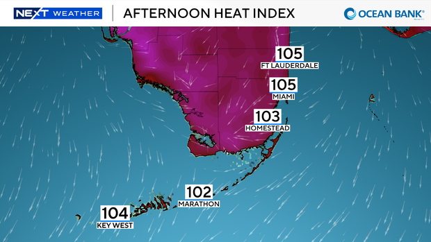
Heat index near 105 degrees before rain chances increase
Despite the chance for rain, dangerous heat will remain a concern. Heat index values are expected to climb to around 105 degrees Tuesday across Broward, Miami-Dade and the Florida Keys, creating a major heat risk.
An area with a low chance of tropical development off the southeastern U.S. coast is expected to drag a cold front toward Florida. While the front is not expected to bring significant cooling, it will increase moisture and help boost rain chances.
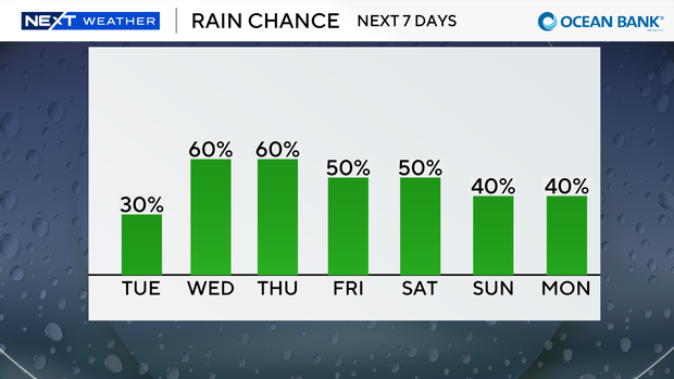
Showers and thunderstorms become more widespread Wednesday and Thursday, with rain chances rising to 60% each afternoon. The additional cloud cover and rainfall should provide some relief from the heat, although "feels like" temperatures could still reach the triple digits.
The increase in tropical moisture will also bring a minor risk of localized flooding, especially across parts of Miami-Dade and Broward counties, where isolated heavy downpours could develop. The flood risk does not mean every neighborhood will see flooding, but the ingredients will be in place for isolated water-covered roads and poor drainage flooding.
Wildfire smoke continues affecting air quality
The weather pattern could also influence smoke from the Atlantic Fire burning in western Broward.
As of early Tuesday, the wildfire had burned about 5,000 acres. Calm overnight winds allowed smoke to spread into parts of Broward and Miami-Dade counties, leading to moderate air quality impacts in some areas, including near Plantation and Fort Lauderdale. Air quality sensors also detected unhealthy conditions south of Doral due to lingering wildfire smoke.
Residents may continue to notice the smell of smoke Tuesday until east and southeast winds strengthen later in the day. However, any afternoon thunderstorms could temporarily shift winds back toward the metro areas, potentially pushing smoke back into more populated communities.
Fourth of July weekend forecast
Looking ahead to the Independence Day holiday weekend, scattered afternoon showers and thunderstorms remain in the forecast each day, with rain chances around 50%.
High temperatures are expected to stay in the lower 90s, while heat index values could once again reach around 105 degrees.
The NEXT Weather team recommends keeping alternate indoor plans for afternoon outdoor events in case storms develop.