Hurricane Erin moves north after causing higher tides, dangerous rip currents in South Florida
For the latest on this system, check the National Hurricane Center's website.
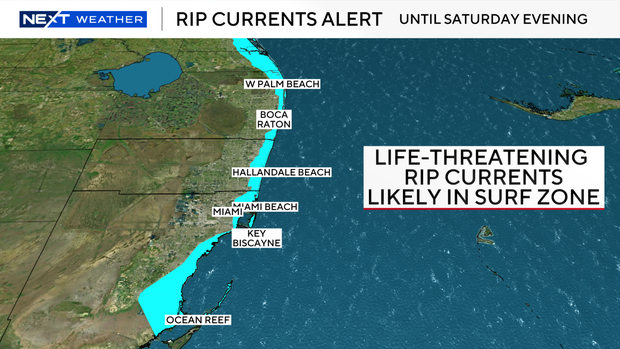
South Florida saw the indirect impacts of Hurricane Erin. The NEXT Weather team said through Saturday there will be an increased risk of swells, rip currents and higher tides.
Surf and rip current risks elevated in South Florida
The City of Fort Lauderdale said Erin is pushing tides about a foot higher than normal. In a post on X, it said Wednesday night's high tide went over the level where they see minor flooding in low-lying areas. The city said through the weekend, mild flooding will be possible during high tides. If there is rain at the same time of the high tide, the city said the water will drain slowly and could cause temporary ponding on streets. It added that once the tides recede, conditions should improve.
The National Weather Service said the risk of rip currents remains high for the Atlantic beaches.
In a post on X, the National Weather Service said swells from Erin arrived in Palm Beach on Thursday with breaking waves and dangerous rip currents.
Higher surf will also be possible for areas along the east coast. Beachgoers are cautioned against swimming at most U.S. east coast beaches due to life-threatening surf and rip currents.
Forecasters track two more Atlantic systems
The National Hurricane Center said as of the 11 a.m. advisory, Erin remains a large hurricane, with sustained winds of 90 mph, as it moves to the northeast in the Atlantic.
On the forecast track, the center of Erin will pass south of Atlantic Canada Friday and then race across the north Atlantic waters.
Elsewhere in the Tropics, the CBS Miami Next Weather team is tracking two areas in the Atlantic.
An area of disorganized showers and thunderstorms associated with a tropical wave is located a couple hundred miles east-northeast of the northern Leeward Islands.
Environmental conditions appear conducive for further development of this system, and a tropical depression is likely to form this weekend while it moves northwestward and then northward, in between the Lesser Antilles and Bermuda.
The National Hurricane Center is giving this system a 90% chance of development over the next 7 days.
Out in the far eastern Atlantic, an area showers and thunderstorms associated with a tropical wave located about a thousand miles west-southwest of the Cabo Verde Islands remains well organized has a 50% chance of development over the next 7 days.
This system could become a tropical depression at any time, but the latest satellite-derived wind data indicate that the system does not have a well-defined circulation center. The system is expected to move into a less conducive environment later today through Saturday, but could reach a slightly more favorable environment again late this weekend into early next week.
Neither of these areas poses a threat to South Florida or the U.S. at this time, but the NEXT Weather team will continue to monitor and provide updates over the coming days.