Hurricane Rachel forecast to reach Southern California as strong waves begin battering coast
There's light at the end of the tunnel for Southern California's atypical October heat wave as temperatures will begin to drop — albeit slowly — on Wednesday and into the rest of the work week, just ahead of Hurricane Rachel's predicted landfall over the weekend.
"I can finally say these five words: 'Cooldown is on the way'," said CBS LA Meteorologist Amber Lee.
That cooldown won't arrive in a large way on Wednesday, but instead slowly over the next few days. On Wednesday, temperatures will still remain abnormally high, although fewer records are expected to fall than in days past.
"The cooling will not be enough to eliminate the heat risk, with mostly 90s across the coasts and 98 to 105 in the valleys," a National Weather Service bulletin said.
While Wednesday's cooldown won't be significant, it'll likely be enough to end a streak in downtown Los Angeles. Tuesday was the fifth consecutive day of 100-degree temperatures recorded downtown, the longest such streak since 1963. According to the NWS, downtown LA's high on Wednesday was 98.
Cooling is likely to continue on Thursday by about 2 to 4 degrees, before Friday's more noticeable 4 to 8 degree drop, the NWS said.
Strong surf begins to batter Southern California coast
On Wednesday night, days before Hurricane Rachel was predicted to make landfall, some coastal communities already began feeling the impacts of the powerful surf.
In Long Beach, aerial footage showed waves crashing into the boardwalk, sending water flying dozens of feet into the air. The city had similarly been slammed by surf in early September, damaging several homes and the boardwalk. It was one of many coastal cities that felt the impact of Hurricanes Marie and Polo, which never made landfall in the U.S., but created extremely strong swells that damaged homes all along Southern California's typically serene coastline.
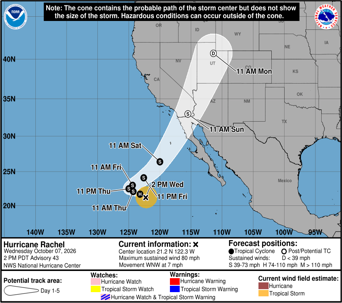
Hurricane Rachel forecast to hit Southern California
The weekend will see a more dramatic switch, as temperatures will become seasonally below average by Sunday. Remnants of Hurricane Rachel could bring rain to the region by the start of next week, early forecasts indicate.
According to the National Oceanic and Atmospheric Administration, Rachel is expected to make landfall at tropical storm strength, meaning coastal communities could see strong winds and flooding, with gusty winds spreading to inland regions in the following days.
"Moisture associated with Rachel will spread over portions of the Southwest United States and northern Baja California peninsula through this weekend," a statement from NOAA said. "This will lead to increasing coverage of rainfall and a threat of flash and urban flooding."
Forecasters predict that parts of Los Angeles, Orange and Riverside counties could see up to an inch of rainfall on Monday.
Along with rain, NOAA says that swells generated by the storm could "cause life-threatening surf and rip current conditions."


