Severe Weather, Including Hail And Tornadoes, Possible Across North Texas Until 10PM
NORTH TEXAS (CBSDFW.COM) - Severe storm development appears likely for North Texas this afternoon and evening. A strong, spring-like storm system continues to roll through the southern Plains and will arrive in North Texas tonight.
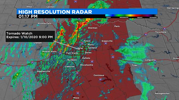
A Tornado Watch was issued early Friday afternoon that covers much of North Texas. It's expected to last until 9 p.m.
In addition to heavy rain and the risk for flooding, there is the possibility for large hail of up to 2", damaging winds up to 65 mph or greater and tornadoes. The area with the greatest threat for severe weather is east of Interstate-35E, but everyone across North Texas should be watchful.
Officials with the Office of Emergency Management in Dallas are urging residents to be mindful of their pets and bring in any plants, outdoor furniture, grills or equipment that could get caught up in high winds.
Most of North Texas is also under a Flash Flood Watch until 3:00 a.m. Saturday.
Severe thunderstorms are expected to develop during the early and mid-afternoon with the strong, main line being the most impactful from late afternoon through late evening. In short, the window for strong-to-severe thunderstorms will be between 1 p.m. and 10 p.m.
The severe weather threat is so significant that Governor Greg Abbott has placed the Texas Division of Emergency Management on standby, meaning medical personal and first-responders -- in boats and helicopters -- will be on standby to assist if necessary.
As of the lunch hour several Catholic schools in Dallas and Plano announced that they would be dismissing classes early. A number of after-school sport activities, at schools across the Metroplex, are also being cancelled. Parents are being urged to check the social media pages of their child's school.
Airline passengers traveling on both Dallas-based Southwest Airlines and Fort Worth-based American Airlines are being given the opportunity to change their tickets or completely rebook flights to avoid the potential bad weather.
As of 12:20 p.m. Dallas Fort Worth International Airport had cancelled nearly 150 flights. In all, more than 85 flights have been cancelled at Dallas Love Field Airport.
Tornado Watches were already issued for a number of counties in central Oklahoma and the CBS 11 Weather Team said North Texas would have the same in the early afternoon. "A strong, spring-like storm system continues to roll through the southern Plains and will arrive to North Texas tonight," said Meteorologist Anne Elise Parks.
Texans are encouraged to follow these safety tips:
- When severe storms threaten, the safest place to be is indoors
- Avoid areas already flooded and avoid fast-flowing water
- Be extremely cautious of water on roads or in creeks, streams, storm drains, or other areas – never attempt to cross flowing streams or drive across flooded roadways and always observe road barricades. Remember, Turn Around Don't Drown.
- Keep in mind that flood dangers are even harder to recognize at night
Forecasts call for some parts of Texas to get up to 4 inches of rain. The squall line is expected to rush east, exiting North Texas just before midnight.
Temperatures will drop into the mid-30s Friday night and to the north and northwest -- around Bowie, Gainesville, and Bridgeport -- in addition to the wet weather there's the possibility for snow. "While there could be some lingering moisture in the pre-dawn hours Saturday for snow flurries, it appears that most areas will stay dry," Parks said.
Afternoon high temperatures Saturday will only warm into the mid 40s.