NEXT Weather Alert: Winter storm impacting Southeast Michigan Wednesday

(CBS DETROIT) - Winter weather is upon us as snowy conditions take over Southeast Michigan. Travel on roadways will quickly deteriorate as snow intensifies by late morning. Heaviest of snowfall will begin at 10 a.m. to 4 p.m. Snow will come to an end as the system moves out this evening. An additional 1-3 inches of snowfall is possible through the evening. It is beautiful to look at however, traveling has been dangerous, with numerous accidents. Please use caution traveling today and stay safe.
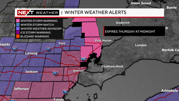
· Winter Storm Warnings have expanded and are currently in effect for Lenawee, Monroe, and Wayne Counties, and now also include Macomb, Oakland, and Washtenaw Counties. These warnings will expire at 8 p.m. Wednesday.
· Winter Storm Warning is also in effect for Huron, Sanilac, and St. Clair, Counties until Thursday at midnight.
· Winter Weather Advisory is in effect for Lapeer and Livingston Counties until 10 p.m. Wednesday.

Whether your location is under a Winter Weather Advisory or Winter Storm Warning, expect the heaviest snow from now until 4 p.m.
Even after 4 p.m., still expect snow to be pumping through the entire region for the evening hours as this area of low-pressure pinwheels through the metro area today. Snow will not be as heavy, but still, it will accumulate.
The snow will start to break up closer to 8 p.m. and scattered snow will be the theme for the early overnight period as this system moves farther away from our region. Giving us a chance to really clean up the snowpack Thursday. This is also the heavy wet snow, that is hard to shovel. So make sure to take frequent breaks.
Those living in the warning areas can expect to receive 4-8 inches of snowfall, while those living in the Advisory area can expect between 3-6 inches of snowfall.
Winds today will be out of the Northeast gusting to 26 miles per hour. These winds could produce some blowing snow as well as some lake effect snow showers along the shoreline in the thumb.
Your NEXT Weather team will have you covered through the storm, and the NEXT Weather Tracker will be driving around the area monitoring road conditions on Wednesday. Reach out to us if you would like the NEXT Weather Tracker to drive in your hometown.
Send any snow reports and totals safely tomorrow if you can to your #NEXTWeather Team.