Severe storms possible throughout Southeast Michigan on Tuesday

A severe thunderstorm warning has been issued for portions of Macomb and Oakland counties until 4 p.m. Tuesday.
St. Clair County is under a severe thunderstorm warning until 4:15 p.m.
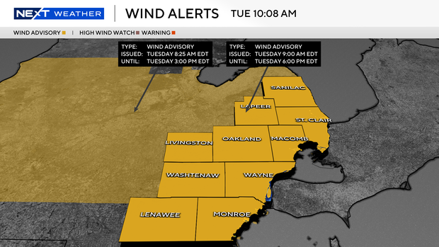
There is a wind advisory until 6 p.m. for all of Southeast Michigan on Tuesday as an area of low pressure and a front moves through the area.
This means winds not associated with individual storm cells will gust up to 45 miles per hour through the day on Tuesday.
The same front will bring a broken line of showers and some storms to Southeast Michigan on Tuesday.
After a little light rain for the morning commute on Tuesday, a couple of storms could produce stronger wind gusts at around 3 p.m.

There is currently a "slight" risk of severe storms for Tuesday afternoon for parts of Southeast Michigan. That is a 2/5 on the severe risk scale from the Storm Prediction Center. This area of risk extends from Port Huron to Detroit down to Lenawee County.
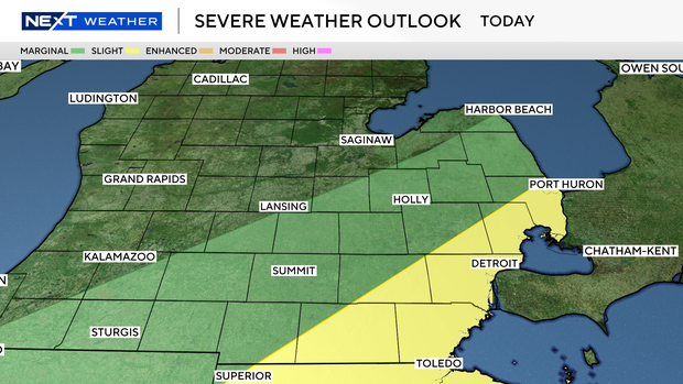
The main threat will be an isolated storm with isolated strong, damaging winds of 60-plus miles per hour.
Most storms will move out by 5 p.m.
Ahead of the front, temperatures will warm into the low to mid-80s across Southeast Michigan on Tuesday afternoon. Behind the front, lows will be in the 30s on Tuesday night. High temperatures will only reach the low 60s by Wednesday afternoon.

Rain chances return on Thursday.