Scattered showers, isolated storms in store for Southeast Michigan Saturday

After a cool start to May, Southeast Michigan is bracing for a quick warm-up on Saturday, but it comes with a catch.
A potent cold front is set to sweep through the region Saturday afternoon and evening, bringing the potential for scattered showers and isolated thunderstorms.
Saturday morning will start relatively quiet with increasing clouds as temperatures climb into the 60s.
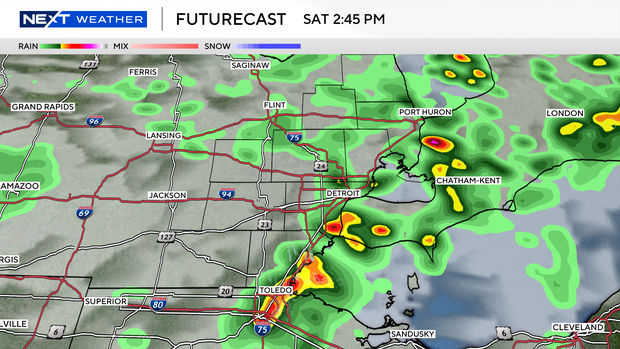
The main window for weather activity looks to open during the mid-to-late afternoon and persist through the evening hours.
The front will move through during peak heating, providing just enough energy for storms to develop.
Overall, a broken line of storms is our main risk in that development window, although some models keep the line forming only to our east.
In this scenario, we stay completely storm-free. However, we have to look at the possibility of that line forming on the approach to Southeast Michigan.
In that case, most areas will see scattered rain, but the more robust cells could produce brief, heavy downpours.
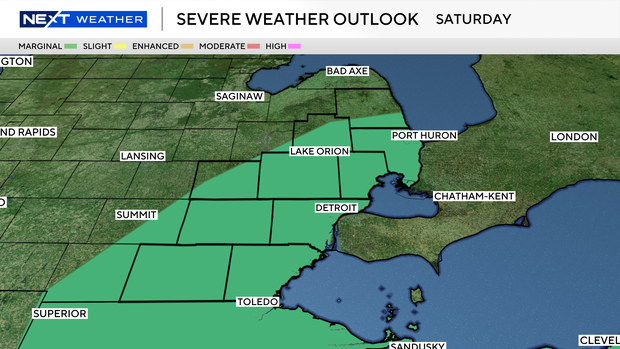
While widespread severe weather is not expected, these isolated storms could pack a punch. Atmospheric conditions are favorable for some storms to produce hail and strong wind gusts if they form.
Once the front clears the area Saturday night, a much cooler air mass will settle in for the second half of the weekend.
Sunday will feel significantly different, with highs likely struggling to leave the 50s.
While the storm risk is isolated, it is always a good idea to have a way to receive weather alerts if you have outdoor plans Saturday afternoon.
Keep an eye on the sky and be ready to move indoors if thunder roars.