Recent mountain snow brings healthy snowpack numbers in Colorado
Days and weeks of snow in the Colorado mountains has resulted in impressive snowpack reports for many of the state's river basins.
Of the eight river basins in the state, five of them had above normal snowpack on Wednesday morning and all basins had increasing snowpack.
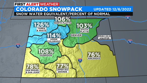
The South Platte basin which includes the Denver, Boulder, and Fort Collins areas was only 3% above normal for December 7 but the Upper Colorado Basin including most of the I-70 mountain corridor was14% above normal and the Yampa Basin including the Steamboat Springs area was 26% above normal.
The southern basins in Colorado including the San Juan, Upper Rio Grade, and Arkansas basins were all at least 20% below normal thanks to most recent storms missing those regions. Fortunately snow is in the forecast for the San Juan and Sangre de Cristo ranges through Thursday morning which should translate into improving snowpack numbers for those regions in the coming days.
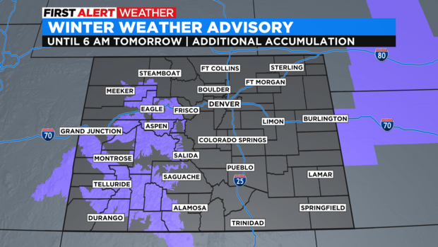
While improving snowpack is good from the standpoint of drought and fire danger in Colorado next year, the surge of recent snow on top of the snowpack from October and November means unstable snow. The Colorado Avalanche Information Center has extended an Avalanche Warning in the mountains through Thursday. It will likely not be renewed since snow show end in the mountains by late Thursday and dry weather is expected for Friday and Saturday.

For Denver and the Front Range, the only chance for snow through the weekend is Wednesday night when a few flurries may develop. There will be no accumulating snow in the metro area through at least Sunday night.