Hot! September starts just like August ended in Denver with more toasty weather
After one of the warmest August's on record in Denver, September also starts hot and mostly dry.
The official high temperature in the city on Wednesday was 94 degrees which contributed to the average temperature in August reaching 76.1 degrees. That's 3.2 degrees above normal which is significant from a climate standpoint.
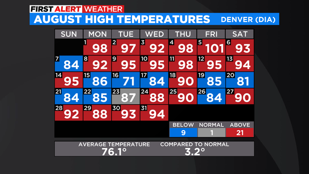
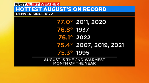
There have only been three years in Denver's recorded history with a higher average temperature in August: 2020, 2011, and 1937. Therefore August 2022 is now officially the fourth hottest August on record.
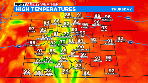
Temperatures will be just as hot on Thursday with at least 93 degrees in the Denver, Boulder, and Fort Collins areas. The "normal" high temperature on first day of September is only 85 but the record is 98 degrees from 2019. So while it's much warmer than normal, it's not quite record territory.
Looking further ahead, the late summer heat wave will continue through at least the middle of next week meaning much warmer than normal temperature for Labor Day weekend. There is a very small chance for showers and thunderstorms anywhere east of the Continental Divide including the metro area on Friday. Then a small chance for thunderstorms in the mountains mainly south of Interstate 70 on Saturday. Otherwise dry weather will dominate the state through most of next week.
With so much mainly dry weather, fire weather conditions will have to be monitored and a Red Flag Warning can not be ruled out somewhere in the state.