Denver Weather: Sunshine Today, Rain And Snow Coming Later This Week
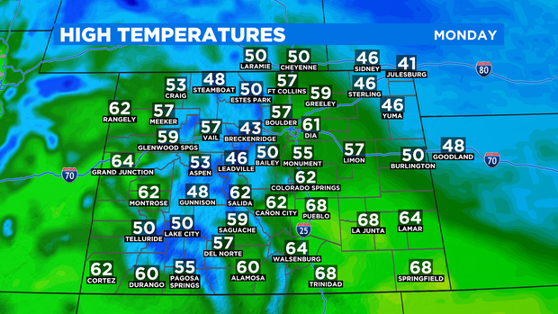
DENVER (CBS4) - After having to wait until the afternoon to see sunshine over the weekend, Monday will be sunny all day on Colorado's Front Range, in the mountains, and on the Western Slope. Temperatures will also be somewhat warmer as a result with highs near 60 degrees in the Denver metro area.

The only exception to the mostly sunny forecast is on the far Eastern Plains where low clouds will cause patchy fog during the morning hours around Sterling, Akron, and Burlington.
Temperatures will be above normal everywhere except on the far northeaster plains on Monday.
Monday and night and Tuesday will be an odd day as moisture will from the Midwest will be transported west into the eastern half of Colorado including the Denver metro area. Therefore skies will be cloudy along with a chance for fog, drizzle, and perhaps a few snow flurries Monday night into early Tuesday morning.
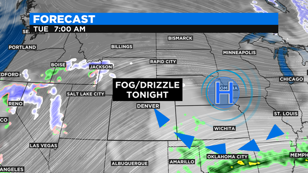
Despite the clouds, temperatures should still manager to reach the upper 50s on Tuesday. Additional sunshine will arrive on Wednesday allow for a return to the mid 60s in the Denver area because a storm coming from the West Coast arrives Wednesday night.
We expect a very good chance for rain and snow across most of Colorado from Wednesday night through Thursday night.
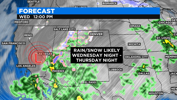
The amount of snow will depend on the exact track of the storm which was not clear as of early Monday morning. The potential does exist for heavy snow at least in the foothills and mountains by late Thursday and possible some heavy, wet snow along the I-25 corridor as well. We'll keep you posted!