Denver Weather: Spring-Like On Tuesday Before Winter Returns Wednesday
DENVER (CBS4) - All of Colorado will enjoy very mild weather on Tuesday before a cold front arrives on Wednesday. Denver and most of the Front Range will eventually get snow.
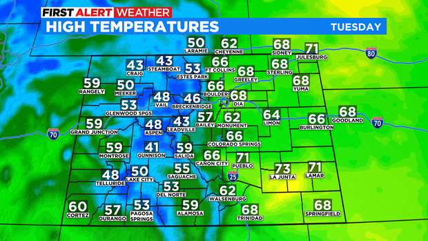
Prior to the cold front arriving in the metro area around 12 p.m. on Wednesday, Tuesday will include temperatures more than 10 degrees warmer than normal for the third week in March. The Denver, Boulder, and Fort Collins areas will experience highs well into the 60s with a few neighborhoods likely reaching 70 degrees.
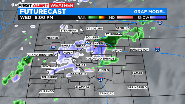
Then the changes arrive on Wednesday with snow spreading from the northern mountains to the I-70 mountain corridor by late morning and early afternoon. Denver and most of the Front Range should remain mostly dry until after 2 p.m. when a chance for rain will develop.
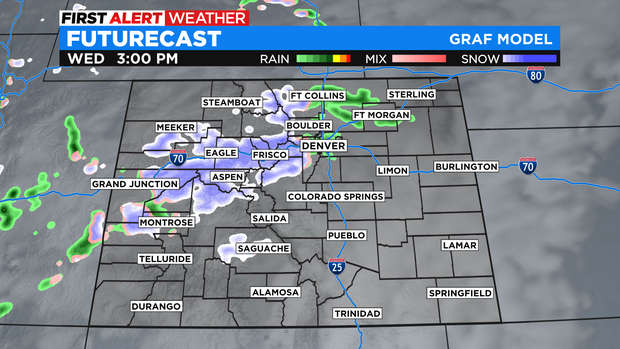
Precipitation in the Denver metro area will stay rain through the Wednesday evening commute before changing to snow mainly after 8 p.m.
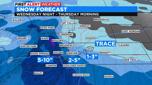
Most of the snow that falls will occur between 8 p.m. Wednesday and 2 a.m. Thursday. Exact accumulation will depend on the exact time the rain changes to snow as well the specific location because there will be a very tight gradient across the metro area.
Generally speaking, the highest snow totals will be for areas above 6,000 feet on the south and west sides of the metro area. The Highway 285 corridor from Morrison to Kenosha Pass and the I-25 corridor from Castle Rock to Monument Hill should get at least 5-10 inches of snow.
Elsewhere, accumulation will be less. The western and southern suburbs of Denver including Arvada, Lakewood, Littleton, and Centennial should mostly get 2-5 inches of snow. The northern and suburbs like Thornton, Aurora, and Brighton should get no more than 3 inches. And for areas farter north and northeast like Longmont, Fort Collins, Greeley, and Fort Morgan, any accumulation should be very minor.
Because of the abrupt change to the weather as well as the heavy snow expected in the southern foothills and on the Palmer Divide, the CBS4 Weather Team has issued a First Alert Weather Day for Thursday morning.
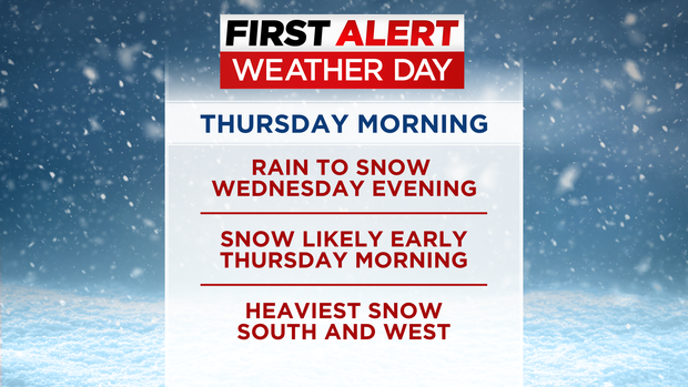
Most of the precipitation that falls during the day on Thursday will be in far eastern and far southern Colorado. For the Denver metro area, most of Thursday will be dry and chilly.
For the mountains, most ski areas in Colorado will get 2-5 inches of snow from Wednesday afternoon through Thursday morning.
Skies will clear statewide Thursday night and sunshine should dominate most of Colorado on Friday and Saturday. Then another storm will approach the area on Sunday with rain possible in the Denver metro area Sunday night and a rain/snow mix is expected on Monday. Another First Alert Weather Day may be issued for Monday.