Denver Weather: Snow Is Guaranteed To Arrive Today. The Question Is How Much
DENVER (CBS4) - A storm racing into Colorado from Arizona will bring cold, snow, and wind nearly statewide on Friday and Saturday. But questions remain on the exact track the storm will take which will have a direct affect on accumulation. Regardless, it seems likely the first accumulating snow of the month will be measured in Denver.
Snow will initially develop in the metro area by early afternoon on Friday. The most significant snow is expected to stay south of I-70. Then a break is expected from Friday evening through much of the night although there will continue to be a small chance for light snow showers.
No winter storm watches, warnings, or advisories are in effect for the Denver, Boulder, and Fort Collins areas and that's because despite unusually low forecast confidence, snowfall amounts are expected to be generally minor along most of Colorado's urban corridor. Most areas will see no more than 4 inches of accumulation and it seems likely amounts will be much lower in the Fort Collins and Greeley areas. Meanwhile, total snowfall from Friday afternoon through Saturday night could be higher along portions of the Palmer Divide including the Castle Rock, Franktown, Kiowa, and Elizabeth areas where more than 6 inches could accumulate.
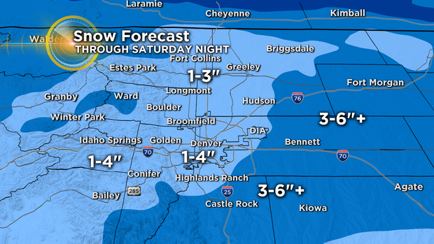
Snowfall is also expected to be minor for the mountains north of Highway 50 including the I-70 mountain corridor and Summit, Eagle, and Grand Counties. These areas should see no more than 6 inches of snow.
It's a different story farther south where a WINTER STORM WARNING is effect for most of the San Juan Mountains. Wolf Creek Pass could easily see 20 inches of snow by late Saturday.
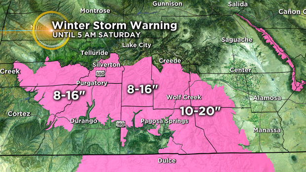
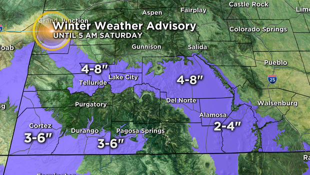
Locations surrounding the warning including Telluride, Lake City, Durango, Pagosa Springs, and Alamosa are under a WINTER WEATHER ADVISORY for no more than 8 inches of snow and in most cases much less.
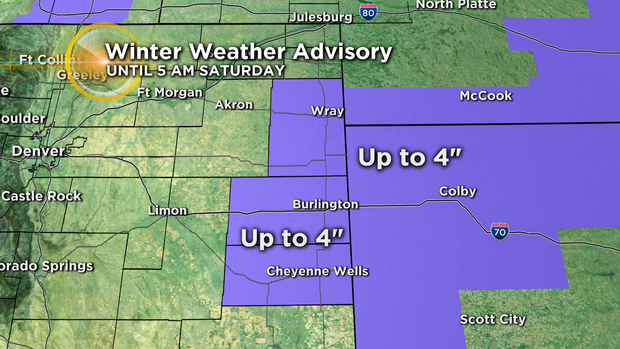
There is also a WINTER WEATHER ADVISORY on the far eastern plains of Colorado for up to 4 inches of snow and a possibility of a thin layer of ice around Burlington and the I-70 corridor east of Limon.
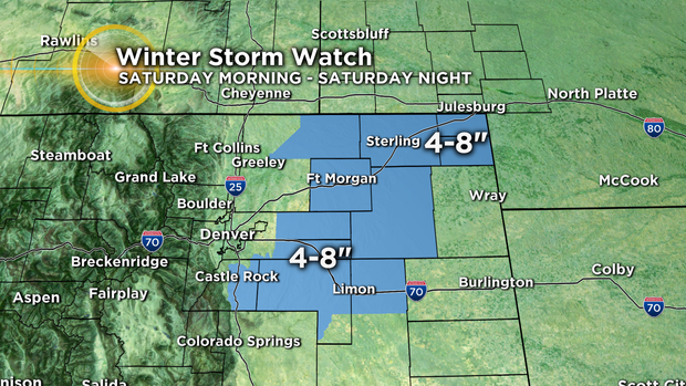
The plains closer to Denver including Limon and Fort Morgan as well as portions of the Palmer Divide in Douglas and Elbert Counties are under a WINTER STORM WATCH from Saturday morning through Saturday night. These areas have the potential of seeing 4 to 8 inches of snow.
The snow ends statewide Saturday night and sunshine returns on Sunday although it will stay chilly for the final Broncos game of the year Sunday afternoon at Mile High.


