Denver Weather: Arctic blast is coming with more snow on Thursday
The snow and cold Tuesday morning is nothing compared to the First Alert Weather Day coming for Thursday
The Denver and Boulder areas received 1-5 inches of snow Monday night into Tuesday morning which made for slick and slow travel. Most of the snow had ended by mid morning and clearly skies will allow for sunshine Tuesday afternoon. Despite the sun, temperatures will remain cold even for November with highs in the 30s.
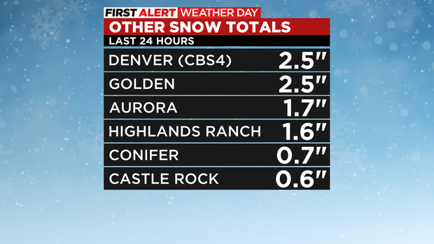
The highest snow totals Tuesday morning where generally across the northwest metro area and into Boulder County where Eire measured almost a half foot of snow.
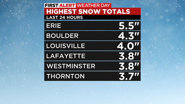
Other areas including downtown Denver and most of Jefferson, Arapahoe, and Douglas Counties received less. In fact, many areas that often have some of the biggest snow totals on the urban corridor like Castle Rock received less than 1 inch. A full list of snow totals is here.
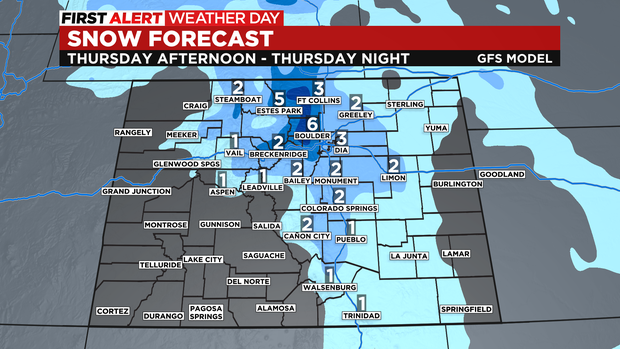
The next storm to impact Colorado will bring more snow and arctic cold on Thursday. CBS News Colorado has declared a First Alert Weather Day for Denver and the Front Range. The metro area will enter the deep freeze Wednesday night while the snow should wait until Thursday afternoon. At this time, the forecast is for 2-6 inches of fluffy snow could fall mostly during the Thursday evening commute. Anyone planning travel late Thursday should be prepared for icy and slick roads and significant delays.
The snow should end along the Front Range by early Friday morning. Clearing skies behind the snow will cause temperatures to turn frigid. The Denver area will experience single digits for the first time this season and some areas could experience record cold Friday morning and/or Saturday morning.
Warmer weather will finally start returning over the weekend and especially next week. The days before Thanksgiving could be slightly above normal for a change.