Denver Weather: Here We Go Again, More Snow On The Way!
DENVER (CBS4) - Another winter storm taking aim at Colorado promises more snow in the mountains Thursday night and a chance for snow in the Denver metro area during the day on Friday. The storm was centered in Northern California Thursday morning and will move quickly east across Colorado by the end of the day Friday. Temperatures will turn colder, wind in the mountains will gust up to 45 mph, and the metro area could pick up a quick inch or two of snow.
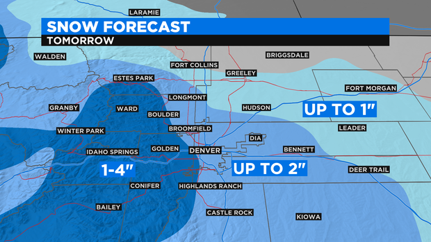
The heaviest snow in Colorado will fall from the Grand Mesa north to The Flat Tops and into the Rabbit Ears Pass region. These areas will get 4 to 8 inches of snow and are under a Winter Weather Advisory from 5 p.m. Thursday until 5 p.m. Friday. Mountain areas farther east including Summit County do no have an advisory but will still get 1 to 4 inches of snow along with enough wind so cause blowing and drifting.
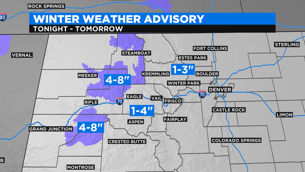
For Denver and the Front Range, the opportunity for accumulating snow should be brief. From late morning through mid-afternoon, there could be enough upslope to produce 1-2 inches of snow around Denver and Boulder. Any accumulation around Fort Collins and Greely would likely be less. Some areas in the foothills including the Highway 285 corridor about Morrison should get at least 1 inch.
The storm will clear the state late Friday allowing for clearing skies on Saturday and gradually warming temperatures into early next week. The chance for a white Christmas in Denver (falling snow on the 25th) seems unlikely at this time.