Colorado Weather: Widespread Rain For The Front Range, Summer Snow In The Mountains
DENVER (CBS4) - An unusually cold for after Memorial Day will cross Colorado Tuesday and Wednesday bringing rain, snow, and temperatures that are 20 degrees cooler than normal.
The first day of meteorological summer on Wednesday (June 1) will include up to a foot of snow for the higher mountains near the Continental Divide. A Winter Weather Advisory has been issued from 3 p.m. Tuesday until 12 p.m. on Wednesday for the I-70 corridor from Georgetown to Copper Mountain, US 40 over Berthoud Pass, US 6 over Loveland Pass, and the entire Rocky Mountain National Park region. Advisories in June are not common but also not unprecedented.
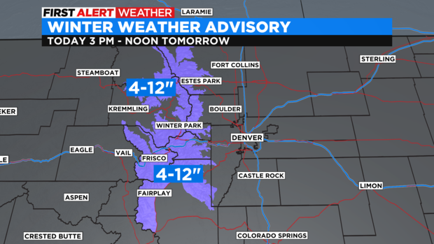
Most areas in the advisory will get at least 4 inches of snow. Areas above 10,000 feet could get up to 12 inches of snow while minor accumulation could occur as low as 7,500 feet including in Black Hawk/Central City, Nederland, and Estes Park. Other towns in the foothills like Evergreen and Conifer could see snow but probably won't measure any accumulation.
For everyone else, including all neighborhoods around Denver, Boulder, Fort Collins, and Greeley, the precipitation will be all rain. There is a chance for rain as early as 1 p.m. in the metro area but most of the moisture will wait until after 5 p.m.
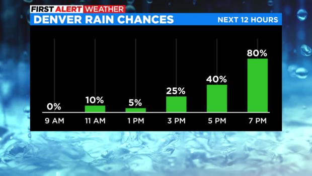
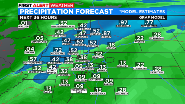
Eventually the chance for rain along the urban corridor will reach near 100% Tuesday night into early Wednesday morning. The amount of rain that falls will vary but there is the potential for over a half-inch of liquid particularly in northern Colorado around Fort Collins, Loveland, Longmont, etc.
By late Wednesday morning, most areas will be dry except on the Eastern Plains where the rain many linger into the early afternoon. Attention will then turn to the unusually cool temperatures for the first day of June.
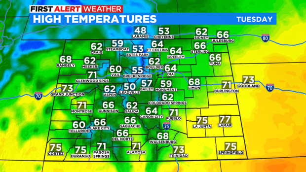
High temperatures on Tuesday will be at least 10-15 degrees below normal for most of the state.
Wednesday will be even cooler with high temperatures struggling to reach the mid and upper 50s around Denver, Boulder, and Fort Collins.

The weather pattern will then shift to much warmer and much drier weather starting Thursday. Temperatures will climb slightly above normal starting Friday and the weekend will include lower 80s on the Front Range. A small chance for late day thunderstorms will also enter the forecast starting Friday.