Chicago Weather Alert: Excessive heat warning through Wednesday night

CHICAGO (CBS) -- Temperatures at Midway International Airport on Tuesday reached 100°, the first time Midway has seen triple-digit temperatures since July of 2012.
With the humidity factored in, it felt like 106° at Midway this afternoon.
The city's official temperature records are measured at O'Hare, so it's not an official record for this date in Chicago, which was 99°, set in 1987.
O'Hare saw temperatures hit 96° by 3 p.m., with a heat index of 103°.
The normal high temperature for June 14 is 80°, which will be the approximate low temperature overnight.
Those sweltering temperatures have virtually all of the Chicago area under an excessive heat warning until 8 p.m. Wednesday, except in Lake and McHenry counties, which are under a heat advisory.
The intense heat comes as cleanup efforts continue in the wake of Monday's storm, which brought a lot of straight-line wind damage. The National Weather Service is also continuing to study the damage to determine if there is evidence of a brief tornado or two.
Wind gusts reached 84 mph at O'Hare on Monday.
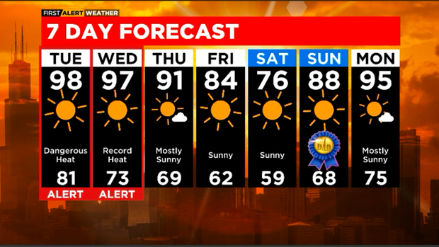
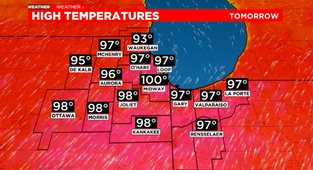
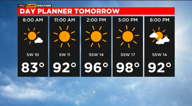
Wednesday's high will reach around 97°, with feels-like temperatures a little over 100°.
Storms at night on Wednesday.
Thursday will be just over 90°.
Relief comes Friday, Saturday and Sunday, with cooler conditions.
Temperaturess are back in the 90s by Monday.
Tonight- Clear, warm and muggy. Low of 81.
Wednesday- Sunny, hot and humid. High of 97. Feels-like temp around 100.
Wednesday Night- T-storms.
Thursday- 91 for a high.