Snow this week in Massachusetts? Maps show latest track for storm in Boston area.

After an incredibly warm start to the month, November is starting to feel a little more like November, and by the end of the week, we could be tracking our next coastal storm.
Before anyone starts digging out the snow shovels, there are a few things you should know.
First, there is growing confidence that an area of low pressure will develop along the East Coast later this week. Second, there is still plenty of uncertainty about where that storm will track and how much cold air will be available.
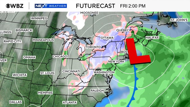
And perhaps most importantly, this is not looking like a widespread snowstorm for southern New England.
At least not right now.
Rain or snow? It all depends on the track
The potential storm would likely develop near the Mid-Atlantic coast on Thursday before moving northeast toward New England on Friday. Depending on how quickly it strengthens and where it travels, we could be dealing with a period of rain, gusty winds and even some wet snow.
But there's a catch.
It's only early November, and we simply don't have a lot of cold air in place. Temperatures this week will generally be seasonable, with afternoon highs in the 50s and overnight lows in the 30s and 40s.
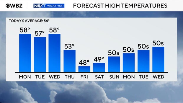
That's not exactly a recipe for widespread accumulating snow.
However, temperatures several thousand feet above the ground could become cold enough to support snow, especially across the higher elevations of central and western Massachusetts.
Places like the Berkshires and Worcester Hills would have a better opportunity to see wet snow than Boston or communities along the coast.
The weather models aren't seeing eye to eye
This is where the forecast gets interesting.
The American weather model, known as the GFS, currently favors a storm tracking farther inland. That would allow milder Atlantic air to spread across much of southern New England, keeping precipitation primarily in the form of rain.
Under that scenario, Boston and much of eastern Massachusetts would likely see a chilly rain, while some higher elevations could experience a changeover to wet snow as colder air arrives.
The European and Canadian models have been suggesting a somewhat different outcome.
They bring colder air into the region sooner, but also track the storm farther offshore.
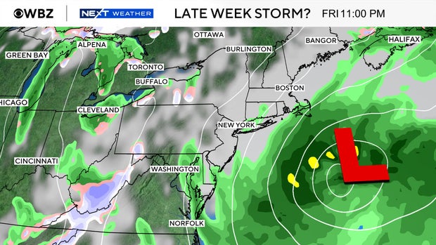
You might think a colder forecast automatically means more snow, but that's not necessarily the case. A storm that tracks too far offshore could leave much of Massachusetts with considerably less precipitation.
In other words, the colder solution isn't necessarily the snowier one.
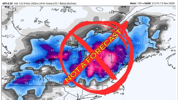
That's why it's important not to get too caught up in individual snowfall maps circulating on social media. A relatively small adjustment in the storm's track could make a big difference in what we actually experience.
Who has the best chance of seeing snow?
For now, the greatest opportunity for accumulating snow appears to be across the higher elevations of western and central Massachusetts, along with portions of northern New England.
A few wet snowflakes could mix with rain in other inland communities, especially if colder air arrives while precipitation is still falling.
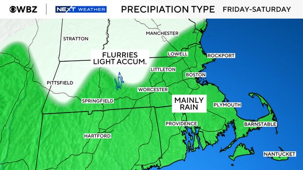
Closer to Boston, along the Interstate 95 corridor and toward the coast, rain remains the more likely outcome.
It's still too early to put out a reliable snowfall accumulation map. We need a better handle on the storm's track, intensity and timing before determining whether any communities could see enough snow to stick.
And remember, there's a big difference between seeing snowflakes in the air and seeing snow accumulate on roads, sidewalks and lawns.
What happens before the storm?
In the meantime, we're looking at a fairly typical November stretch of weather.
Tuesday should be mainly dry, although west to northwest winds will make it feel a little cooler.
Clouds will continue to dominate into Wednesday, with temperatures generally staying close to where they should be for this time of year.
By Thursday, our attention turns to the developing storm along the East Coast.
What we're watching next
There are three big questions that need to be answered over the next couple of days: How close will the storm track to New England? How quickly will colder air arrive? And will there still be enough moisture around when temperatures become cold enough for snow?
Those answers will ultimately determine whether this becomes a rainy November storm, a rain and snow mix for some inland communities, or a system that largely misses us.
Once the storm moves away, a fresh push of colder air and gusty northwest winds could make next weekend feel considerably more like winter.
For now, there's no reason to get worked up over the early snowfall projections. The storm potential is real, but significant accumulating snow across southern New England is far from a sure thing.
We'll be watching how the forecast evolves throughout the week, particularly as the weather models begin to agree on a more consistent storm track.