Record Cold Possible Tonight, More Flakes Too?
Find Eric Fisher on Twitter and Facebook
Kicking things off tonight with a look back at winter. Yes, in the eyes of climate records, winter ended when we turned the page to March. NOAA defines Meteorological Winter as December, January, and February. Yes it's a little silly consdering we all know it snows outside those months and can be extremely cold to boot, but that's the way things are done at the moment! As always with data, there are plenty of ways to organize and manipulate it. In any case, NOAA released their comprehensive report on the season today. There are some things that may surprise you and others that won't.
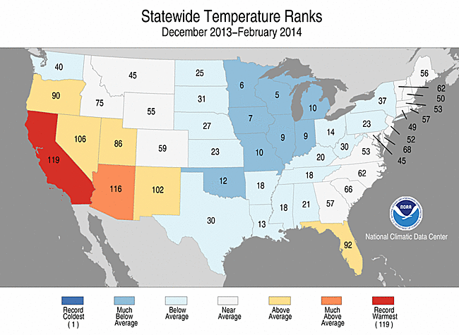
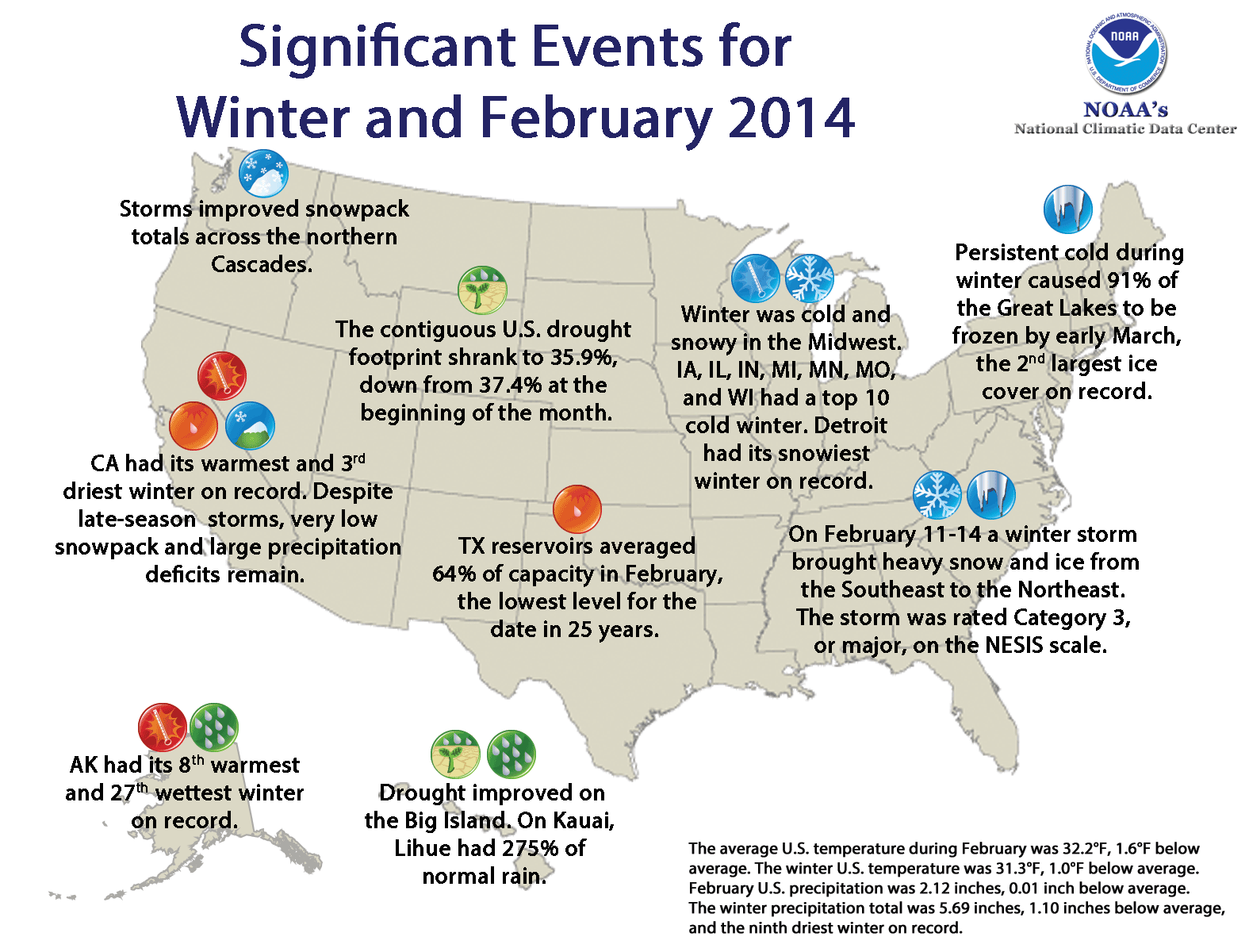
The brunt of the cold was by far felt across the Midwest, where Great Lakes ice cover reached its highest extend ever recorded so late in a season. Many states saw Top 10 coldest winters on record.
Certainly not shocking that is was cold out. But maybe not quite as cold as you think. It went down as the 34th coldest winter on record for the Lower 48, with an average temperature of 31.3º (1.0ºF below the 20th century average). Just looking at the 'caboose' of the season, February came in as the 37th coldest February on record.
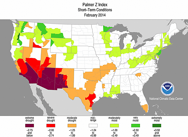
We know that quite a few snowstorms made headlines and help bury some cities in the east, but when you look at the larger picture of the contiguous U.S. the story was about dry weather. It was the driest winter since 2001/02, and ranked as the 9th driest ever recorded. The extremely dry west helped to weigh down that average, with historic drought ongoing in California.
Nothing too wild and crazy here at home though. Winter ranked as just the 53rd coldest, below average but nothing to write home about. And although Boston snow is running above average- it's nowhere near the record books. Just a good old fashioned Boston-area winter. One which doesn't seem to want to let go anytime soon!
You can check out some additional maps, data, and highlights on the NCDC State of the Climate webpage.
Looking into our own weather for the next few days, we may set a couple more records! We had a very good shot at setting some 'record low maximums' today (always the most difficult one to describe). Essentially, the coldest high temperature for the date. The only fly in the ointment? We were still 'warm' at midnight. So all of the area high temps for this date, when you look back into the record books, will generally show 30s and 40s. But the vast majority of the day was in the 10s and 20s, which is a solid 25º below average and extremely rare for this time of the year. And just 2 years ago on this date, it was 71º! March is definitely a wild month.
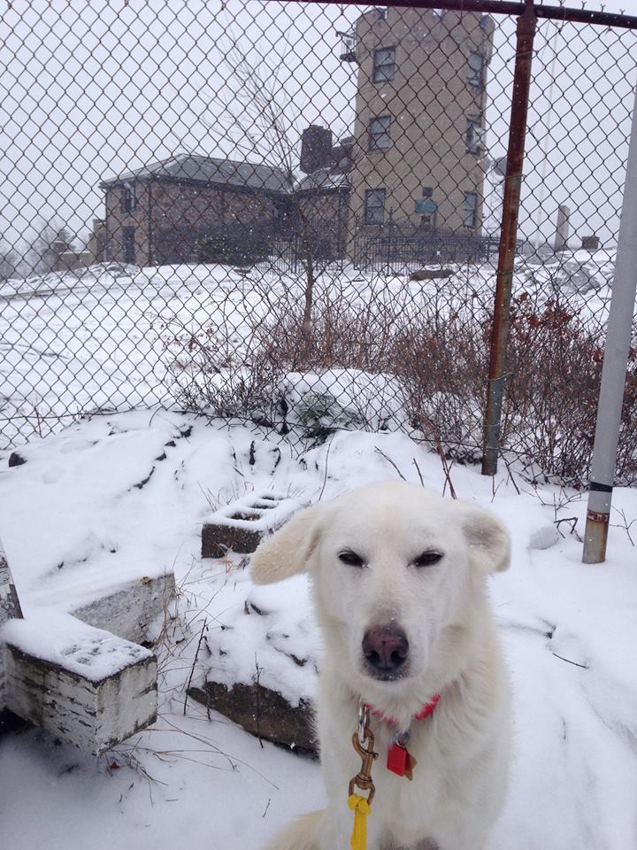
'Pearl' - a helper for the Observer Team at Blue Hill Observatory, looks surprisingly not too pleased with today's snow (considering the dog is an Alaskan Husky!). Thanks Brian Fitzgerald for the photo.
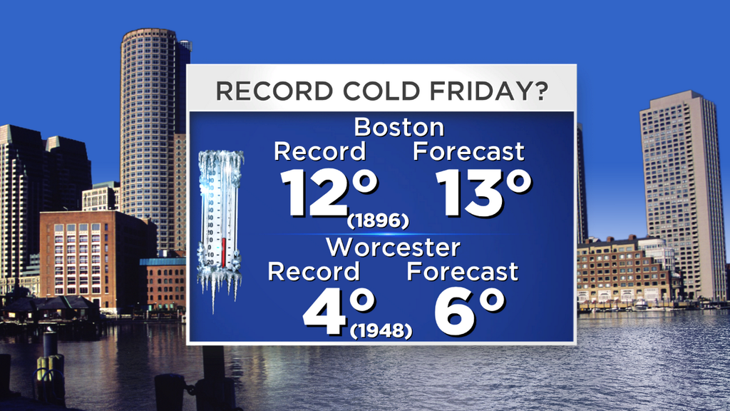
But while we missed the boat on record highs, we may set some new record lows. Boston's record is 12º set a whopping 118 years ago, so again we're in rare territory. Worcester's record low is 4º. We may end up just on the mild side of both these records, but it will be interesting to watch through the night as skies gradually clear out and the wind calms down.
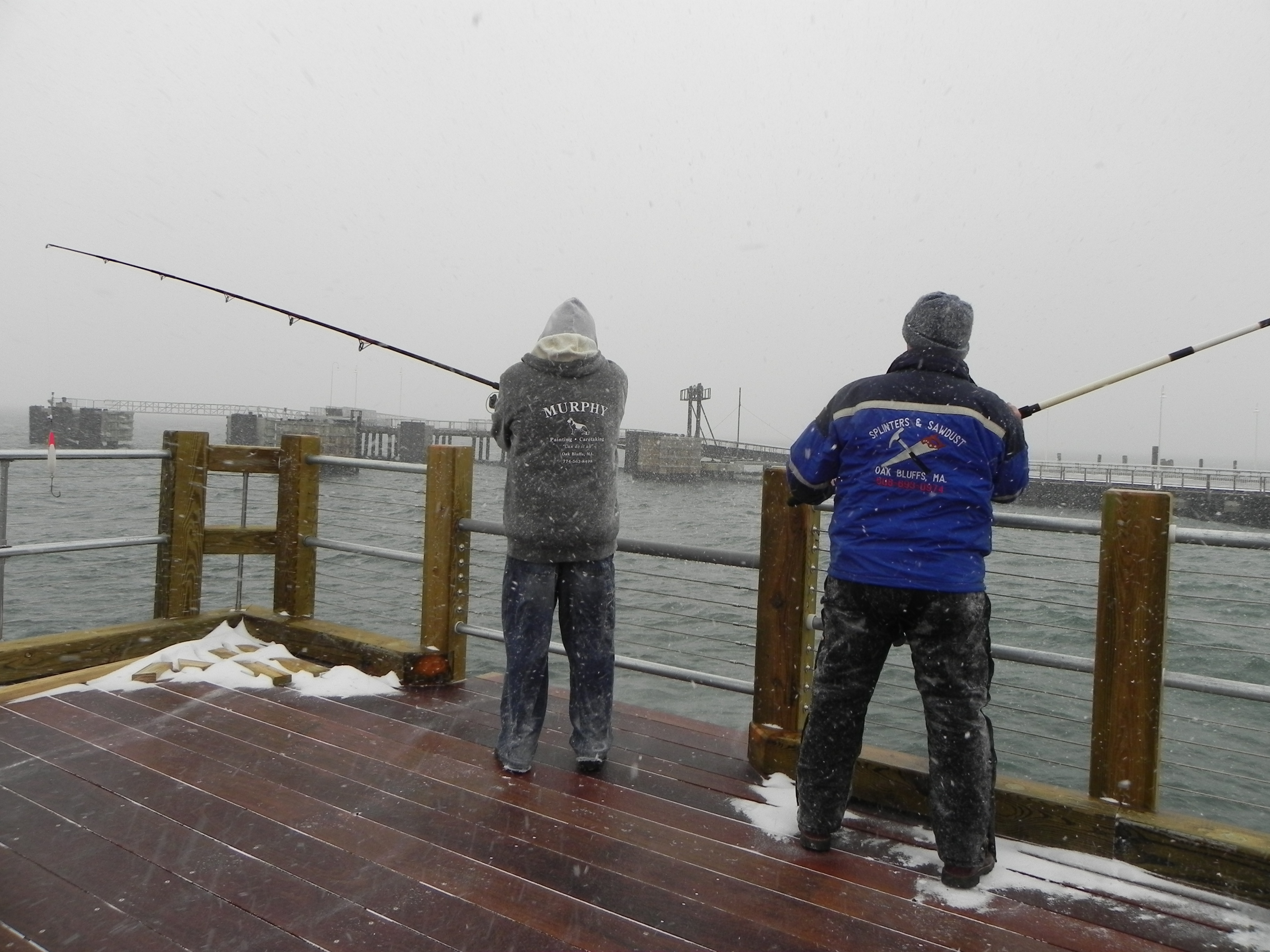
Bob and Rick sent in this one from Oak Bluffs today. Temps near 20, wind chill near 0, gusts to 40mph, flakes flying? Perfect fishing weather of course. A hardy bunch here in New England.
Tomorrow brings relief after a frigid morning. With a mix of sun and clouds we should manage the 30s to low 40s by days end. As high pressure drifts off to our south we'll get into the 'return flow', and 850mb temps will rise extremely rapidly from about -18C tonight to +2C tomorrow! This rapid warming brings 2 things. Firstly, some WAA (warm air advection) clouds that will filter the sun. But also a gusty breeze, which should be in the 10-25mph range out of the southwest during the midday and afternoon hours.
A cold front heads in Friday night into Saturday morning, and it's not out of the question there could be a couple spots of freezing drizzle. We'll have a better idea of that potential tomorrow. Saturday morning it should be mild enough for scattered rain showers, which will become more sparse by late morning. So a bit of a damp start to the day will transition to brighter skies and temps in the 40s to low 50s. It's the warmest day we've got in our 7-Day, so enjoy! If you're planning a long Boston Marathon training run - the best bet to avoid some raindrops would be to wait a little during the morning hours. No major issues.
Much like last weekend it gets cooler behind the front, and Sunday will be breezy with highs in the 30s to near 40. Not balmy, but no major issues for any St. Patrick's Day shenanigans. The parade in Southie looks fine, and the sun should help keep things a little more comfortable.
Next Snow Potential/Uncertainty:
We're keeping a wary eye on some storminess that's projected to be hanging around off the East Coast by Sunday night. All the models have been onto this, but there's still a pretty high level of uncertainty regarding the exact track. Even amongst ensemble members, there are many possibilities. Although I will say that they're in a bit better agreement today compared to yesterday, and that the overall trend has been just a little bit farther north.
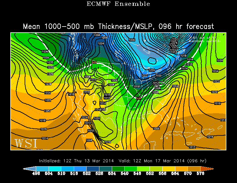
Source: WSI EnergyCast
The biggest questions are - how deep will a lobe of the polar vortex dips down across SE Canada, how deep will a trough digs across the southeast, and where exactly high pressure sets up over New England? This high will be supplying plenty of cold arctic air, so no real precipitation type questions. If something comes on down, it will be snow. And between the high and low we should produce a pretty decent pressure gradient, so I'm expecting a gusty wind off the ocean on Monday (not a bright and warm St. Patrick's Day this year).
But I do think that the strength of the high and and abundance of dry air over SNE should help to fend this storm off to our southeast. The towns that are most at risk for some accumulating snow are the ones throughout the South Coast, Cape, and Islands. At this time not expecting anything huge, but we may have to break out the plows. There's also a decent shot all of it stays out to sea and we just get a cold and gray day. So stay tuned for updates as the ingredients come together and the forecast confidence increases over the weekend.
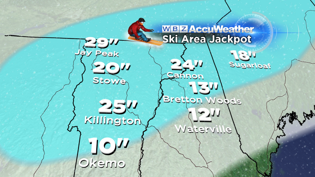
And in any case, we've got plenty of snow to deal with already! The ski mountains made out like bandits. There's a ton of hamstring-burning powder across Vermont, New York, New Hampshire, and Maine. In fact, some of the higher terrain has 50" of snow on the ground here in mid-March. In short, you'll probably be able to ski and snowboard for as long as you want this spring. If you have a trip planned for April, I wouldn't worry about it one bit. Nothing warm enough in the forecast to lead to significant or rapid melting.
I'd wager that every day from Sunday through the start of next weekend will feature below-average temperatures here in the Boston area. The combo of an Arctic high to start the week, plus a generally onshore flow through Thursday morning, and finally a cold front passage on Thursday, will keep us from any warm westerly winds. Maybe not quite the news you were hoping to hear. At least the averages are increasing (average highs now up to 46º in Boston and 47º by the end of the weekend)....so below average doesn't hurt quite as much. And with increasing daylight all we really need is sunny skies.