Hurricane Ida's Remnants Could Bring Several Inches Of Rain, More Severe Weather Thursday
BOSTON (CBS) – Worst. Summer. Ever.
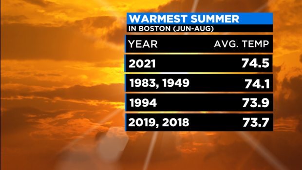
OK. Maybe that is a tad dramatic, but seriously, in my mind, this summer has been nothing but soggy and sweltering. With two days left in meteorological summer (June-July-August) it appears as though Boston will finish as the warmest summer ever recorded and the second wettest summer ever recorded.
Those two things are very hard to accomplish in the same season. Typically, a wet summer will lead to below average temperatures given the number of cloudy/wet days keeping the temperatures down. But in the summer of 2021, when it wasn't raining it was sweltering.
And now, as we approach the end of our summer, the main weather story this week is yet another tropical system set to move through New England with potentially flooding rainfall. Hurricane Ida made landfall in southern Louisiana Sunday as a dangerous category 4 storm. It has since weakened to a tropical storm and currently is bringing flooding rainfall to portions of Louisiana, Alabama and Mississippi.
Ida will continue to weaken as it moves northward (over land) and will likely be downgraded to a tropical depression later Monday. Tropical systems are notoriously very hard to get rid of though. While they lose their wind power rapidly over land, they almost always maintain their general structure for many days. Ida will be no different.
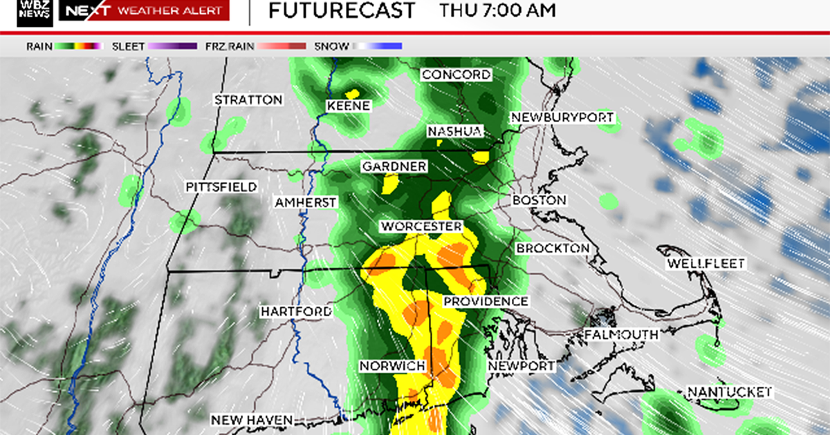
Current forecasts show the remnants of Ida moving through portions of Tennessee, West Virginia, Pennsylvania and finally off the New Jersey shore late on Thursday. While the winds won't be a major factor, Ida will bring torrential, flooding rainfall along its entire route, dumping 3-to-6 inches (or more) along the way.
In the summer of 2021, it seems all roads of tropical systems and heavy rainfall lead through New England. Ida's rainfall will arrive here late in the day on Wednesday. Heaviest rain is expected from about 1 a.m. to 1 p.m. on Thursday.
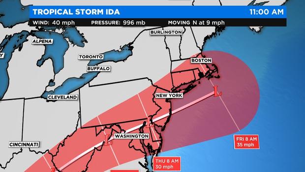
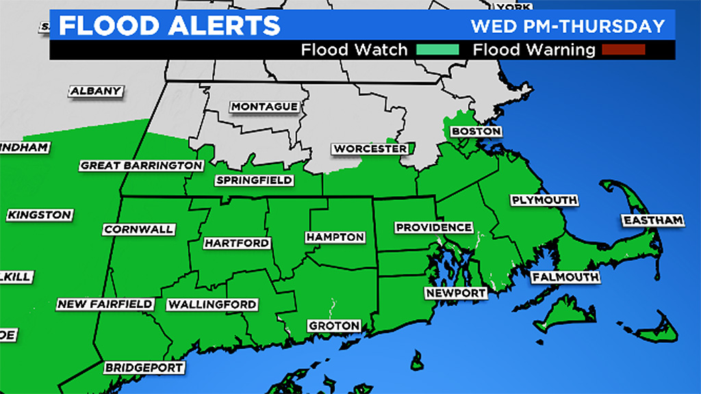
The current forecast track shows Ida's remnants sliding just south of New England Thursday, putting us right in the bullseye for very heavy rainfall once again. If this forecast holds, we should be prepared for several inches of rainfall on Thursday, perhaps as much as 5-to-6 inches (or more) in some locations. Given the wet summer we have had to this point, this is not welcome news.
This would undoubtedly lead to widespread (localized) flooding issues, water in some basements as well as some small river and local streams coming out of their banks. As with Elsa and Henri, there would also be a threat of some severe weather with Ida, remember, we had some spin-up tornadoes with the other tropical systems this summer.
We strongly urge that you stay tuned to forecast updates in the next 24-48 hours as we track Ida up the East Coast.
I feel the need to leave you with some good news.
For those planning a final getaway this coming Labor Day Weekend, it looks much better than Memorial Weekend and the 4th of July holiday. Granted, the bar was set very low with cold, soaking rainfall on both of those occasions in 2021.
Currently Labor Day Weekend looks pretty decent - on the cool side with highs mainly in the 70s. Probably a few scattered showers around Sunday and/or Monday, but nothing near a washout.
Follow Terry on Twitter @TerryWBZ