Eye On The Next Storm!
 It was an astonishing study of contrast in New England this morning. The temperature gradient was gargantuan- close to 35 degrees ranging from the lower 50s on Cape Cod to the upper to middle teens in central MA into northern New England! Supplied by a strong high pressure system in Canada over the past few days, arctic air became entrenched to the north. Meantime, the coastal storm approached to New England in an attempt to dislodge the cold air. A battle ensued yielding brief thundersnow around Boston and we thumped with several inches of snow in much of the region near and north of the MA Pike. Boston's official station at Logan Airport checked in with 4.2". Farther and farther west and north of the city, the amounts rose to 8-12" with more than a foot over many areas of eastern NH into southern ME. As it warmed more quickly aloft, there was a spell of sleet and freezing rain followed by a switch to plain rain as the lower level air finally warmed above freezing up into northeastern MA. With that transitioning transpiring, there was a transformation of the snow cover from light fluff to a heavier crusted cement which made for difficult shoveling. To make matters even worse, once the storm center crossed over the Cape Cod Canal and over MA Bay, the cold air that was jammed up to the north collapsed southward producing a flash freeze. Many roads that had been treated earlier by the plowing crews and became wet suddenly iced up. Cars and trucks became encased in ice as light freezing rain and freezing drizzle caused some chaos for a couple of hours. The cold air plunged through Boston and down onto the Cape. While sudden drops of 10-15 degrees took place north of Boston, a dive of more than 20 degrees occurred over southeastern MA and Cape Cod but without the widespread ice. High winds enhanced the tides and surf producing more beach erosion and minor flooding along the coast.
 The storm is long gone now but we have to deal with icy areas tonight especially on some town streets, parking lots, driveways, steps, etc. Be extra cautious. The sky will become filled with moonlight as the clouds decrease. While this is happening, another arctic cold front will be advancing into northern New England and it will settle through southern sections tomorrow morning. The very dry air in place means there will be only scattered patches of clouds associated with this frontal passage. The very cold air passing over the Great Lakes will stir up some snowsqualls and a plume of them might streak out across NY into at least a portion of the Berkshires. Other squalls could hit parts of the northern mountains later tonight and tomorrow morning. Expect overnight lows in the upper teens to near 20 followed by a sluggish rise to near 25 at midday tomorrow before falling back a few to several degrees the second half of the afternoon. The cold brisk wind will add some chill to the air. As a ridge of high pressure moves over the area tomorrow night, we will have calm conditions and a mainly clear moonlit sky and it will be bright reflecting off the new snow cover. The Full Cold Moon or Full Long Night Moon is exactly full at 4:28 am Tuesday. So it is quite appropriate that it will be so cold at that time with temperatures down in the single numbers north and west of Boston.
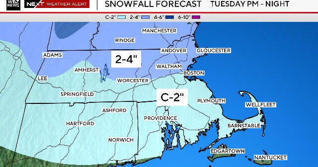
 The eye is now focused on the potential of additional accumulating snow Tuesday afternoon into early Wednesday. An initially benign clipper system from the Great Lakes is destined to evolve into a rapidly intensifying ocean storm. When upstream blocking is underway, these systems can decelerate and blow up quickly resulting in nasty nor'easters for us. Presently, it appears that significant strengthening will not occur until the system is exiting the area so we will only get swiped by a spell of light to moderate snow amounting to about 2 up to 6 inches. I cannot, however, completely rule out a more robust scenario but the odds are against that solution currently. Anyhow, windy weather will occur on Wednesday as the storm is bombing out offshore so we'll end up with any snow or flurries early giving way to developing sunshine and highs in the lower to middle 30s. Thursday will be quiet and milder with highs in the upper 30s.
As a ridge of high pressure builds off the Mid-Atlantic Coast later in the week, a southwesterly wind will drive much milder air into the Northeast. I wouldn't be surprised to see temperatures in the range of 45-50 on Friday as a cold front approaches from the west. This might set off a brief shower followed by sunshine on Saturday. After that, another slug of moisture will be advancing northeastward in the southern stream so we will be watching a potential rain to ice to snow event unfolding about a week from today. It will again be a battle of the air masses to see if the cold or the warm wins. We shall see.
Todd Gutner will post his thoughts tomorrow morning and Eric Fisher will follow later in the day.
Make it a great week!