Chill Returns, Winter Next Week?
Find Eric Fisher on Twitter and Facebook
Beneficial rain! It was a good Thursday across parts of the area, especially southeastern Mass which as expected got the more significant rain totals. Hyannis came in with nearly an inch and a half of rain for the event, helping to make up ground on a very dry August-November. However, amounts were pretty light around and to the NW of Boston (generally 0.1-0.4"). So we've still got some work to do.

Rainbow as rain departed Thursday evening from Lisa in West Boylston
The story is now about the cold, which makes a comeback tonight. A gusty westerly breeze will deliver a cold and dry air mass, with temperatures dropping down through the 30s and dew points crashing back into the 20s by tomorrow morning. So you'll wake up to a dry and chilly air mass instead of the mild and muggy one we enjoyed at the start of Thursday.
A frisky northwest wind will make it feel even colder on Friday, with highs staying in the mid/upper 40s and wind gusts to 35mph at times. For cloud cover, a deck of stratocumulus should develop and linger over the region to mix in and out with the sun. Can't rule out a few snow flurries too, especially for the Berkshires Monadnocks, and southern Greens.
Down the thermometer will tick Friday night, back into the 20s by Saturday morning. And although we'll kick off the weekend with crisp sunshine, most models show a pretty good layer of high relative humidity in the mid and upper levels for Saturday afternoon. That spells a deck of clouds that will veil the sun and yield a chilly feel, with temperatures staying in the 40s for most towns.
A weak low will pull through northern New England Saturday night and Sunday, but without much fanfare for us. Just a slight risk of rain/snow showers, especially northward into NH and VT. We may clear out and enjoy a pretty nice Sunday afternoon with highs in the 50s and breezy conditions. Veteran's Day will start out nice but we'll be eying a front which will blast us back into winter by Monday night. There's even a chance we could get some snow squalls rolling through with that passage! Tuesday looks downright cold, and some towns (especially higher elevations) may stay in the 30s! More of the same on Wednesday, and then there's the question of a storm track. Models continue to oscillate back and forth on possible solutions, which is perfectly normal in the 6-8 day range. Suffice to say, nothing is set in stone! But I think there's a good shot someone on the East Coast will see snow next week. The most likely candidates seem to be the central Appalachians, but we'll just have to monitor trends over the next few days.
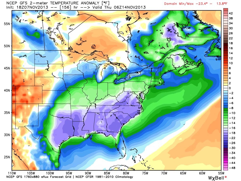
In any case, you can place bets on the cold. While it'll be wintry enough here, the biggest anomalies (departures from average temperatures) will be to our southwest. Take a look at Wednesday night! A huge area of temperatures 20-30º below average down throughout the Gulf Coast states and Mid-Atlantic. Yowza. Lots of rockin' fireplaces in the eastern U.S. next week.