Heavy rain, gusty wind and chance for a brief tornado Thursday night

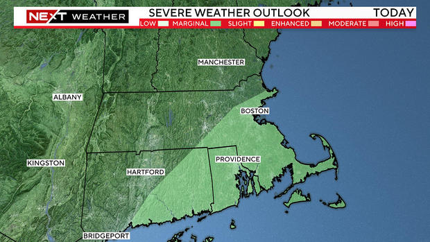
BOSTON - The WBZ-TV Weather Team is issuing a NEXT Weather Alert for another round of downpours and storms on Thursday night. Isolated severe storms are possible with flooding rain, damaging wind gusts and even a brief tornado.
A storm system will track across southern New England and exit the area by early Friday morning.
A few showers will develop Thursday afternoon with steadier rain and embedded storms increasing in coverage by the evening.
Unfortunately, it looks like the rain gear will be needed at Gillette Stadium for the Patriots preseason opener Thursday night in Foxboro.
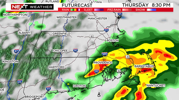
The greatest risk for any severe weather will be in southeastern Massachusetts. Areas like Bristol and Plymouth counties into the Cape and Islands should be weather aware through the night.
The biggest threat with this system is localized flooding from any torrential downpours that set up. After such a soggy July and flash flooding earlier this week, it won't take much to cause more flooding. The Cape and Islands should expect a widespread rain up to an inch, with locally higher amounts where thunderstorms set up. In fact, there is a Flood Watch posted for much of central and eastern New England.
The secondary concern would be the threat of damaging winds and the risk of a brief tornado. Make sure to have your alerts turned on on your phone in case a warning is issued in your area.
This threat comes after flooding rain across the region turned lawns into lakes and roads into rivers in some communities on Tuesday. From the Merrimack Valley to Metrowest, 3-to-7" of rain fell, with isolated higher amounts!
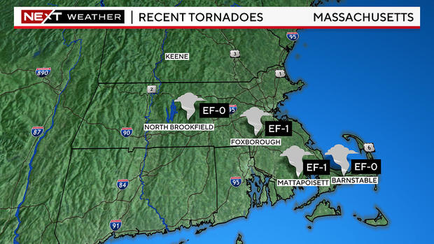
The South Coast and Cape didn't escape the severe weather either. One to three inches of rain fell and two tornadoes touched down late Tuesday morning just before noon. An EF-1 tornado tracked through Mattapoisett and an EF-0 tornado moved through Marstons Mills in Barnstable. No injuries were reported. We've recorded four tornadoes so far this summer in Massachusetts.
We will dry out as the sun returns on Friday. While Saturday will start off dry, the risk of more showers and storms are possible late in the day and into Sunday. We'll continue to update the forecast as new information arrives on wbz.com.


