Boston snow winds down after overnight night storm, but "harshest, toughest week" of winter to come
BOSTON - A quick-hitting snowstorm hit most of Massachusetts Sunday night into Monday before an arctic blast of air arrives on Tuesday and Wednesday.
Buckle up folks, we've got a tough winter stretch ahead of us. There is a good chance that, when all is said and done, this week may be the harshest, toughest week of the entire winter.
The WBZ Weather Team has issued a NEXT Weather Alert for the snowstorm AND the bitterly cold weather to follow on Tuesday and Wednesday.
Timeline of snowstorm
After midnight the snow lightened up and is set to move out by sunrise, however temperatures will continue to drop into the teens early Monday morning leading to icy conditions on any untreated roads and walkways.
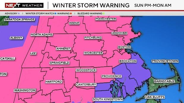
The National Weather Service issued a Winter Storm Warning for much of the state including Boston starting Sunday afternoon into Monday morning for difficult travel conditions and heavy snow.
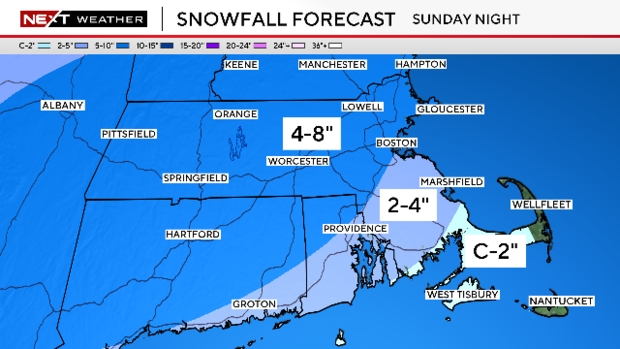
This is where we are expecting the most snow with 5-10 inches expected and where snowfall rates reached 1-2 inches per hour through the evening and Sunday night.
After dawn on Monday, the storm will taper off very quickly and the rest of the holiday will be sunny but very cold.
How much snow is expected?
The lower snow totals across eastern Massachusetts got mixing or changing to rain. The higher amounts are likely to the north and west, partially thanks to colder air out that way and a bit of a fluff factor.
- We are forecasting 4-8 inches north and west of Boston. Higher end of that range in the elevated areas and lower end closer to 495 and 128.
- 2-4 inches from south of Boston to Providence thanks to milder temperatures and the potential for some mixing.
- A coating to 2 inches over extreme southeastern Massachusetts including Plymouth and the South Coast.
- The Outer Cape and Nantucket will be mainly rain.
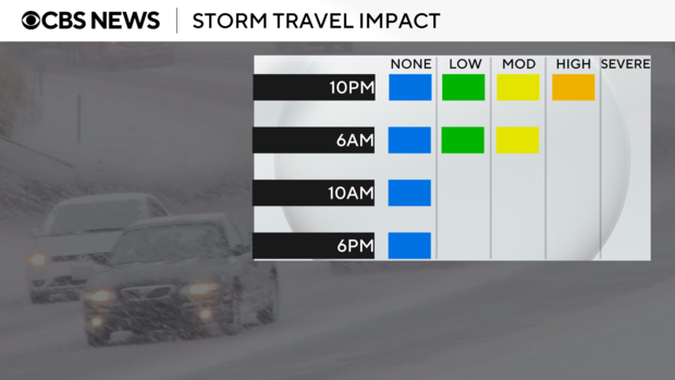
There are no wind or coastal concerns. This storm is all about the snow. Expect roads to quickly deteriorate Sunday night. If you have plans to go out Monday morning, it may be prudent to hold off an extra hour or two and give the crews time to clean up.
Bitter cold to follow
Immediately following the storm will be a true arctic blast. Temperatures will be the coldest they have been in several years. We are forecasting four consecutive days with highs in the teens and low 20s. The last time we had two or more consecutive days highs under 20 degrees was back in 2018!
Low temperatures will be below zero in many of the suburbs Tuesday, Wednesday and Thursday morning! Thankfully, the winds won't be really strong, but any amount of wind with temperatures that low will add an extra bite to the cold.
Finally...there will be a follow-up storm ejecting out of the Gulf of Mexico on Tuesday. Most models currently keep it well south of New England...BUT, we cannot yet rule out some additional snow the middle of next week.
Because it stays bitter cold through next week, the snow will be sticking around for a bit. It's a good idea to clear it as soon as you can.


