Maps show how cold it will get in Massachusetts this week from Arctic blast
BOSTON - The harshest week of winter thus far has begun, kicking off with several inches of snow in much of Massachusetts.
A widespread 4-to-8 inches of snow fell across most of southern New England by early Monday. Slightly lower amounts fell over extreme southeastern Massachusetts.
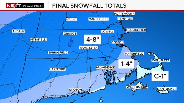
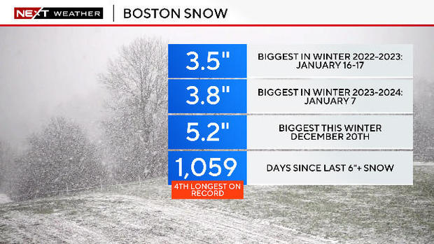
Boston had its second biggest snowfall of the season with 5 inches. This brings the season total slightly over a foot. In Worcester, 5.8 inches fell, giving the city just over 18 inches this season.
Boston is still waiting on a 6+ inch snowstorm. It has been a remarkable 1,059 days since that last occurred.
Bitter cold in the Boston forecast
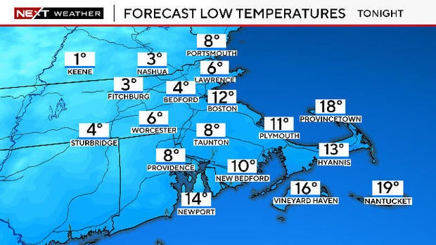
That was just the beginning. The WBZ Weather Team has issued a NEXT Weather Alert for the bitter cold the next several days.
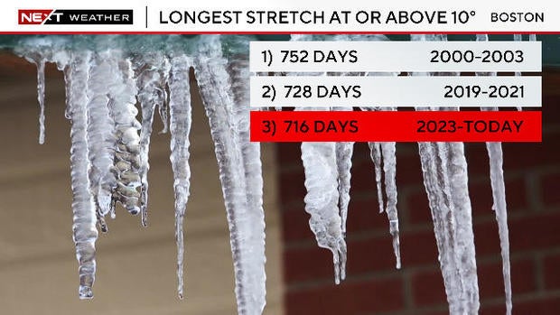
This week will be one of the coldest weeks in southern New England in years. It has been 716 days since Boston dipped below 10 degrees. That streak, the third longest in recorded history, is likely to end this week.
While it will be cold, it will not be record-setting cold this week. The records for daily low maximum and daily minimum temperatures over the next several days will not be broken in the city.
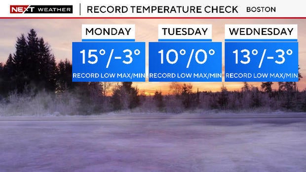
We will not see temperatures drop anywhere near where they did in February 2023 when so many of our fruit trees were destroyed.
Having said that, the next few days will still be quite uncomfortable.
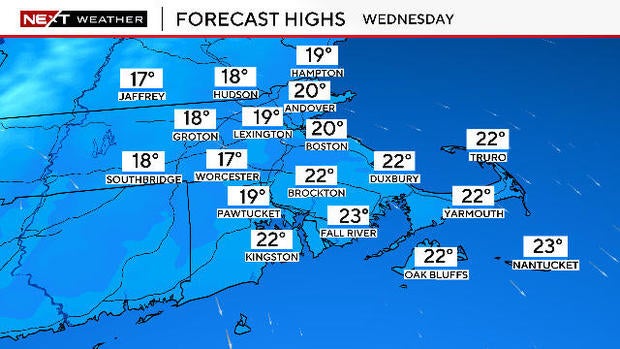
How cold will it get in Boston?
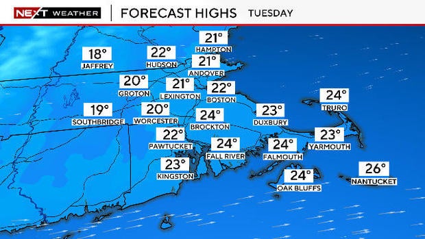
TUESDAY: Morning low temperatures will drop into the single digits across most of the suburbs.
Afternoon high temperatures will range from the upper teens to low 20s.
WEDNESDAY: The cold bottoms out. Morning lows will range between -5 to 5 in much of the area. Boston is likely to fall below 10 degrees for the first time in two years.
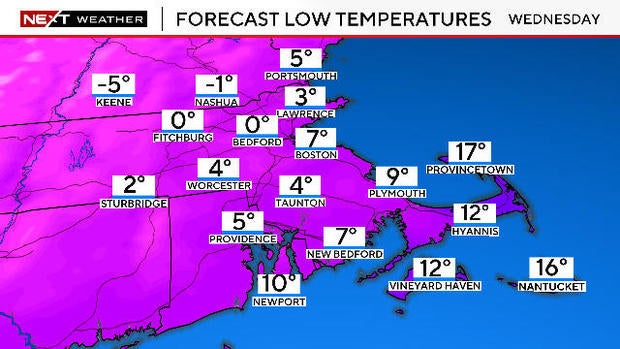
Daytime highs will stay in the teens for the vast majority of the area.
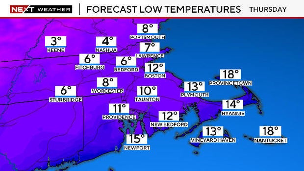
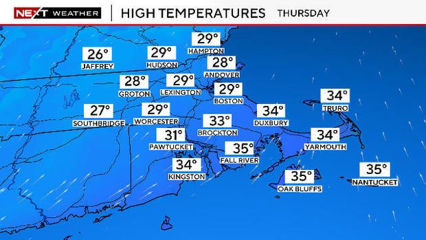
THURSDAY: Temperatures begin to recover. Morning lows mainly in the single digits.
Daytime highs recover into the 20s north of the Mass Pike and some low 30s to the south.
Thankfully, the winds will not be too strong over the next few days. Gusts will stay below 30 mph, however even a slight wind in an airmass this cold will add a nasty bite.
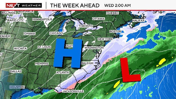
The storm track will be shunted well south of New England this week so we do not expect any significant additional snowfall.