Boston Marathon 2025 road closures, parking restrictions and MBTA changes on Patriots' Day
The 2025 Boston Marathon is Monday, marking the 129th running of the signature New England race. As a result, there will be a massive number of streets along the 26.2 mile route that will be closed to traffic. There will also be plenty of parking restrictions.
WBZ-TV will have complete coverage throughout the day, including information on the winners, and how to track your favorite runners.
When will roads open back up after the marathon?
The timing of closures and when roads reopen varies by community. Below is a town-by-town look at road closures for Marathon Monday throughout the course.
Hopkinton road closures
All roads near the Boston Marathon starting line and Hopkinton Town Common will close at 6:30 a.m. That includes Main Street, Ash Street, Park Street, and Hayden Rowe.
Then at 7 a.m., other roads that lead to the downtown area will be closed to vehicle traffic. Those roads leading to downtown will be blocked off in the following areas:
- West Main Street at Lumber Street
- Wood Street at Elm Street
- Hayden Rowe Street at Chestnut
- Ash Street at Blueberry Lane
- Cedar Street at Legacy Farms North
- East Main Street at every intersection
Any roads that are adjacent to where runners, spectators, volunteers or workers are located will also be blocked.
Ashland road closures
Road closures are scheduled in Ashland for the area of Route 135 from 6:15 a.m.-1:20 p.m.
Route 135 eastbound and westbound in Ashland will close at 7:15 a.m. No cars will be allowed on Route 135 after 7:30 a.m.
Crossing traffic will be allowed until 8:30 a.m., but then the route will remain closed until all runners are through Ashland.
Framingham road closures
In Framingham, Route 135 will also be closed from about 7:30 a.m. to 2 p.m.
Natick road closures
About four miles of the course stretches through Natick. As a result, Route 135 will be closed from 7:30 a.m.-2:45 p.m.
Wellesley road closures
Wellesley is the halfway point of the Boston Marathon. The race enters town on Route 135 at the Natick line near Wellesley College, where the signature "scream tunnel" is located.
The course then moves east on Central Street through Wellesley Square, continues onto Washington Street (Route 16) east through the Wellesley Hills and into the Lower Falls. After moving through Wellesley, runners exit into Newton.
Cars will only be able to cross over the marathon route using Route 9 under Route 16. The following traffic restrictions will be in place from 8:30 a.m. until about 3:30 p.m.
- Central Street (Route 135) closed from the Natick line to Grove Street
- Washington Street (Route 16) closed from Grove Street to the Newton line
- No traffic allowed across the race route once the road is closed
- No one parked in lots along the route will be allowed to leave until the road is open
- Additional road closures will be in place along the route
Newton road closures
A long list of roads in Newton will be closed from 8 a.m. until 7 p.m. to accommodate the marathon.
Marathon route:
- Washington Sttreet from the Wellesley line to Auburn Street
- Commonwealth Ave. from Auburn Street to the Boston line
- Commonwealth Ave. Carriage Lane from Washington Street to the Boston line
- All feeder streets along the marathon route will be closed 60 feet back from the course
Secondary roads:
- Beacon Street from Washington Street to Dorset Road
- Beacon Street Extension (North of Washington Street)
- Beacon Street from Hammond Street to Boston line (Residents only)
- Centre Street from Homer Street to Ward Street
- Chestnut Street from Beacon Street to Highland Street (Residents only)
- College Road from Beacon Street to Commonwealth Ave.
- Concord Street from Hagar to Washington Street
- Evelyn Road from 192 Evelyn Road to Fuller Street
- Fuller Street from Day Street to Evelyn Road (Residents only)
- Grant Ave from Beacon Street to Ward Street (Residents only)
- Grove Street from Washington to Moulton Street
- Hammond Street from Ward to Hammondswood Road
- Helene Road/ Cotter Road from Paulson to Fuller
- Homer Street rom Commonwealth Ave. to Centre Street·
- Lowell Ave. from Commonwealth Ave. to Hull Street (Residents only)
- Old Colony Road from Priscilla to Commonwealth Ave.
- Quinobequin Road from I-95 southbound ramp to Washington Street
- Walnut Street from Horner Street to Mill Street (Residents only)
- Ward Street from Hammond to Manet (Residents only)
- Woodland Road from Cheswick Road to Washington Street
Brookline road closures
In Brookline, Beacon Street will be closed to all cars from 8 a.m. until 6 p.m. In addition, crossing Beacon Street will be limited for much of the day.
People attempting to cross Beacon Street on foot can do so at Tappan, Webster, and Hawes streets.
"If you need to cross, be prepared to wait a while. These crossover locations are unavailable between 1pm and 3pm!" police warned.
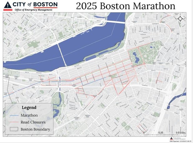
Boston road closures
Many roads will be closed in Boston as throngs of people visit the city on Marathon Monday. You can find complete details on the map below, or on the City of Boston website.
Boston parking restrictions
Parking meters are free on Patriots' Day in Boston - that's the good news. The bad news is that parking will be restricted on several streets in the Back Bay on Monday and Saturday.
Below are the parking restrictions for Marathon Monday and the days leading up to it.
No Stopping through April 24
- Exeter Street (east side), from Boylston Street to Blagden Street
- Blagden Street (south side, opposite side of library), from Huntington Avenue to Exeter Street
- Blagden Street (north side, library side), from the BPL Driveway to Exeter Street
- Boylston Street (both sides), from Exeter Street to Dartmouth Street
- Boylston Street heading easterly by Copley Square Mall from Dartmouth Street to Clarendon Street
- Blagden Street (north side), Dartmouth Street to BPL Driveway
- FIREHOUSE ONLY: Hereford Street (both sides), Boylston Street to Public Alleys #443 & 444
No Stopping through April 22
- Exeter Street (west side), Alley 441 to Boylston Street
- B.A.A. VEHICLES ONLY: St. James Avenue to Stuart Street
No Stopping April 19, 20 and 21
- Beacon Street (south side, Boston Common side), from Charles Street to Joy Street
- Boylston Street (both sides), from Dalton Street to Dartmouth Street, unless otherwise posted
- Dartmouth Street (both sides), from Boylston Street to Commonwealth Avenue
- Exeter Street (both sides), from Newbury Street to Huntington Avenue, unless otherwise posted.
No Stopping April 17-21
Clarendon Street (both sides), from Newbury Street to Stuart Street
No Stopping April 19-21
- Beacon Street, from Bay State Road to Brookline Town Line (both sides)
- Berkeley Street (both sides), from Stuart Street to Newbury Street
- Boylston Street (both sides), from Dartmouth Street to Charles Street, unless otherwise posted
- Cambridge Street (both sides), from Court Street to Sudbury Street
- Charles Street (both sides), from Boylston Street to Beacon Street
- Hereford Street (both sides), from Public Alleys #443 & 444 to Newbury Street
- Saint James Avenue (both sides), from Arlington Street to Dartmouth Street
- Stuart Street (both sides), from Huntington Avenue to Arlington Street
No Stopping April 20 and 21
- Clarendon Street (both sides), from Public Alley 436 to Newbury Street
- Newbury Street (both sides), from #29 Newbury Street crossing over Berkeley Street to #69 Newbury Street
No Stopping April 19 12:01 a.m. through 3 p.m.
- Bay State Road Street (both sides), from Beacon Street to Silber Way
- Clarendon Street (both sides), from Newbury Street to Boylston Street
- Newbury Street (both sides), from Dartmouth Street to Exeter Street
- Silber Way (both sides), from Bay State Road to Commonwealth Avenue
No Stopping Marathon Monday
- Arlington Street (both sides), Beacon Street to Isabella Street
- Beacon Street, Brighton (both sides), Chestnut Hill Avenue to Brookline Line
- Beacon Street, Back Bay (South side, Public Garden side), Charles Street to Arlington Street
- Berkeley Street (both sides), Columbus Avenue to Commonwealth Avenue, unless otherwise posted
- Belvidere Street (both sides), Huntington Avenue to Massachusetts Avenue
- Boylston Street (both sides), Massachusetts Avenue to Dalton Street
- Cambria Street (both sides), Boylston Street to the loading dock of the Hynes Center
- Charles Street South (both sides), Park Plaza to Boylston Street
- Chestnut Hill Avenue (both sides), Commonwealth Avenue to Beacon Street
- Clarendon Street (both sides), Commonwealth Avenue to Columbus Avenue, unless otherwise posted
- Cleveland Circle (both sides, parking area adjacent to Cassidy Playground & parking area adjacent to Sutherland Road) from Beacon Street to Chestnut Hill Avenue, 24 hours
- Columbus Avenue (both sides), Arlington Street to Dartmouth Street
- Commonwealth Avenue (south, inbound, side), Beacon Street (Kenmore Square) to 80' east of Hereford Street
- Commonwealth Avenue, Lake Street to Chestnut Hill Avenue (inbound)
- Dartmouth Street (both sides), Saint James Avenue to Columbus Avenue
- Deerfield Street (both sides), Commonwealth Avenue to Bay State Road
- East Dedham Street (both sides), Harrison Avenue to Albany Street
- Exeter Street (both sides), Commonwealth Avenue to Newbury Street
- Fairfield Street (both sides), Boylston Street to Commonwealth Avenue
- Gloucester Street (both sides), Commonwealth Avenue to Boylston Street
- Hereford Street (both sides), Commonwealth Avenue to Newbury Street
- Hanover Street (both sides, for Patriots' Day Parade), Tileston Street/Clark Street to Battery Street
- Kenmore Street (both sides), Newbury Street to Beacon Street
- Nassau Street (both sides, for Tufts Medical), from Washington Street to Harrison Avenue
- Newbury Street (both sides), Arlington Street to Brookline Avenue excluding the section already posted
- Plympton Street (both sides), Harrison Avenue to Albany Street
- Raleigh Street (both sides), Bay State Road to Beacon Street
- Stanhope Street (both sides), Berkeley Street to Clarendon Street
- Scotia Street (both sides), Dalton Street to St. Cecilia Street
- St. Cecilia Street (both sides), Belvidere Street to Boylston Street
- Washington Street (both sides, for Tufts Medical), from Oak Street to Nassau Street
- Washington Street (east side/even side), from Nassau Street to Kneeland Street
- Blagden Street (both sides), Huntington Avenue to Exeter Street, unless otherwise posted
- Bromfield Street (both sides, for Patriots' Day Parade) from Tremont Street to Washington Street
- Congress Street (north side, Faneuil Hall side) for Patriots' Day Parade, State Street to Hanover Street
- Commonwealth Avenue, Charlesgate West to Deerfield Street (outbound)
- Dalton Street (both sides), Boylston Street to Clearway Street
- Huntington Avenue (northwest side, odd side), Blagden Street to Massachusetts Avenue
- New Chardon Street (both sides), Merrimac Street to Cambridge Street
- Providence Street (both sides), Arlington Street to Berkeley Street
- State Street (both sides) for Patriots' Day Parade, Congress Street to Washington Street
- Tremont Street (both sides) for Patriots' Day Parade, Cambridge Street/Beacon Street to Stuart Street
- Washington Street (both sides) for Patriots' Day Parade, Bromfield Street to State Street
Using the MBTA on Marathon Monday
Contactless payment is offered by the MBTA for subway and bus travel.
The MBTA website features a map of how you can take the T or Commuter Rail to some of the best viewing and cheering locations along the marathon route. Some parts of the Framingham/Worcester Commuter Rail line are less than half a mile from the Boston Marathon course, while the Green Line C Branch runs parallel to the runners.
The MBTA urges people not to drive to the finish line or other popular viewing areas with widespread parking restrictions in place. Daily parking rates at MBTA stations range from $2-$15.
MBTA changes on Patriots' Day
Copley Station will be closed all day on Marathon Monday. Stations at South Street, Kent Street, and Saint Mary's Street will be closed from about 10 a.m. to 6 pm.
The MBTA said it may adjust or temporarily close other stations near the Boston Marathon finish line if warranted.
Trains on the Red, Orange, Green, Blue and Silver lines will operate on a weekday schedule, and will also have additional service added before and after the marathon. Bicycles are not allowed on trains for Marathon Monday.
Commuter Rail trains on the Framingham/Worcester line will operate on a special schedule. There will be inbound and outbound trains added due to anticipated high volume of passengers. All other Commuter Rail lines will run on a normal weekday schedule.
Bicycles will not be allowed on trains starting at 5 p.m. on Sunday through the end of service on Monday.
The bus stop at Copley Square on St. James Ave. is out of service through April 22. The MBTA said anyone looking to use the bus will be detoured to the stop on St. James Ave. at Clarendon Street.
Routes 55 and 65 will be suspended all day Monday. Route 1 will operate with increased service from 9 a.m.-9 p.m., with buses arriving as frequently as every five minutes. Routes 8, 9, 10, 43, 51, 57, 60, 62, 86, 94, 95, 101 and 350 will all be shortened or detoured. The 47, 59 and 66 buses will be split into two routes.
For more information, visit the Boston Marathon guide on MBTA.com. Up-to-the-minute service information can be found by signing up for T-Alerts.