Adding More Showers
You know that July has been excessively hot with the mean temperature at a whopping 7.9 degrees above the average prior to yesterday's relief. Boston's July average allotment of six 90-degree days has almost been reached with its most recent 5 consecutive-day stretch and there are 22 days remaining! There will be no more 90s until next week when another hot spell is in the works. Meantime, the "cool" weather of the past 24-36 hours gave us an opportunity to get re-energized and flush the stale air out of our homes. The backdoor cold frontal arrival Monday afternoon was a saviour and that front will be retreating northeastward through the region today as a warm boundary. This means the temperatures and the dewpoints will be climbing above yesterday's levels. Despite the murky start with mist and fog, the chance for more pronounced sunny breaks is much higher than yesterday following the boundary passage.
There will be a few scattered showers and storms amidst the mist mainly over southeastern MA during the morning commute with showers and storms 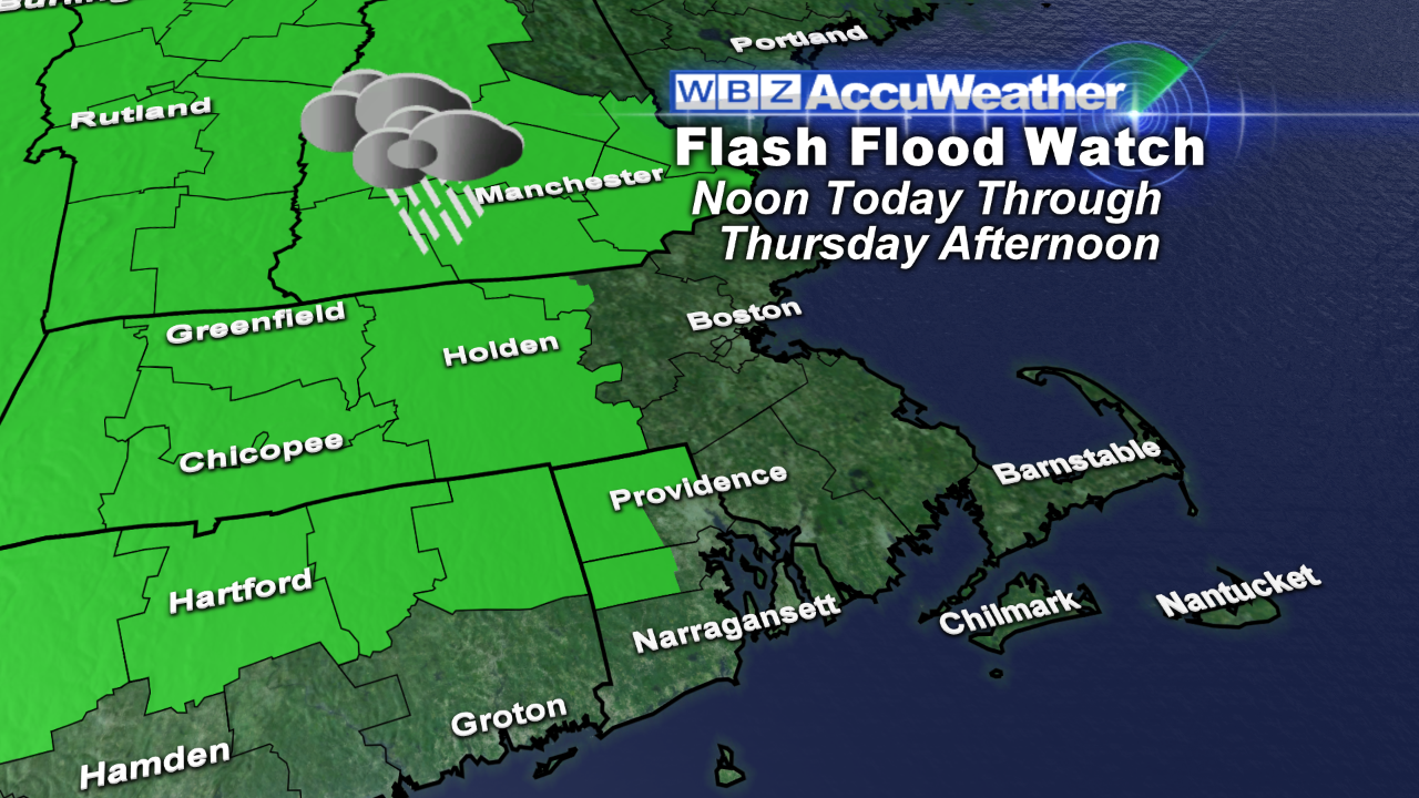 breaking out again especially north and west of Boston later this afternoon into the early evening. Some of these will drop drenching downpours and the National Weather Service has issued a Flash Flood Watch for areas north and west of Boston from noon today through tomorrow afternoon. There will be additional showers and storms tomorrow as a weak cold frontal boundary shifts into the region from the west. Currently, it has decent momentum but as it reaches western New England early tomorrow, it will decelerate and slowly dawdle to the coastline by late in the day. This will provide a good boundary for the axis of action so some more downpours are anticipated. Furthermore, an approaching upper air trough of low pressure is likely to close off into a complete circulation over New England as blocking thrives over the Atlantic. Consequently, the surface wind becomes northeasterly and the occasional showers continue through much of Friday so it will be cooler in the lower to middle 70s. The humidity will drop from oppressive later today into tomorrow to high late tomorrow then moderate on Friday when it will be rather damp.
Looking ahead, the upper level low parked over the region will create sufficient instability for scattered showers and storms to develop on Saturday with a few breaks of sunshine sandwiched in. Temperatures should rise to the upper 70s. With time, this upper air low will actually move southwestward away from New England which suggests that Sunday will be partly sunny with a much lower risk of any showers as temperatures rise to the lower 80s inland and stop at the 70s along the coast due to a bit of a sea breeze.
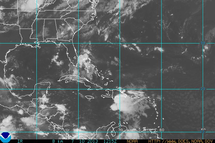
Tropical Storm Chantal will be downgraded to just a tropical wave this morning and that is very good news. It appears that conditions will be unfavorable for re-strengthening as the system curves toward the Bahamas and Florida by early Saturday. Chantal looks rather ragged in this picture displaying the storm center about 150 miles south-southwest of Santo Domingo. Contrast that with the impressive photo of Typhoon Soulik with its 140 mph winds. This typhoon will strike the northern tip of Taiwan in 2 days.

Todd Gutner posts his blog early this evening and I shall return early tomorrow morning.
Make it a great day!


