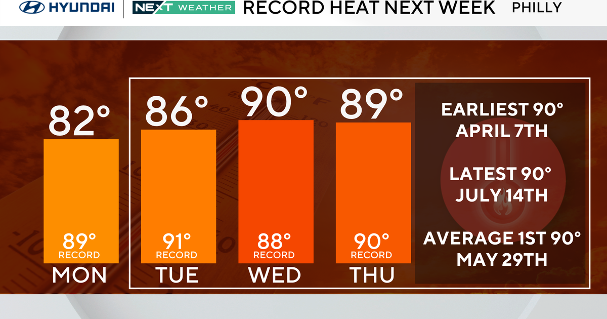
WEATHER BLOG: Remnants Of Isaac
The spinning low that was once the center of tropical Isaac is still off to our west, slowly drifting across Kentucky. It continues to push tropical moisture our way, giving rounds of rain and thunderstorms. And since this is a tropical air mass (high dewpoints in the 70s indicating a lot of moisture), there has been heavy rain underneath any thunderstorm that does form.
The low will keep its slow eastward progress the next few days, keeping us in this air mass. Expect rounds of scattered rain and thunderstorms, with heavy rain underneath any storm that does form. We saw some flooding in Salisbury and DC yesterday, and that continues to be a concern until what was Isaac finally clears us on Thursday.
Since dewpoints will remain high, it will feel rather sticky outside during this time. Temperatures will only drop to the low 70s overnight with locally dense fog, then rebound to the mid 80s the next few afternoons. When we do clear this storm and sunshine returns, temperatures will take a jump up to near 90 degrees Thursday afternoon. The warm air will hang around Friday before a new front approaches the Mid-Atlantic sometime this weekend.
The next front is going to be a strong one, with much drier and cooler air behind it. However, for us, there are questions about what it will do and when exactly it will do anything - all because of tropical storm Leslie. Leslie is still a strong tropical storm spinning in the open Atlantic, north of the Caribbean Islands. It will move to the northwest the next few days, where it will move into an atmosphere conducive for strengthening. It looks like Leslie will become a hurricane later this week. Then, there is still the chance that Leslie could make a turn more to the west - partly being drawn in by our approaching weekend front. Our weekend weather depends on how the tropical system and this front interact. If Leslie gets closer to North America (more New England/Canada), it will stop up the front. If the front overpowers Leslie, Leslie will stay away from land but we will feel effects from the front. We will be watching this closely and keep you updated. Stay tuned...