Air quality expected to improve in Maryland as severe storms arrive Saturday

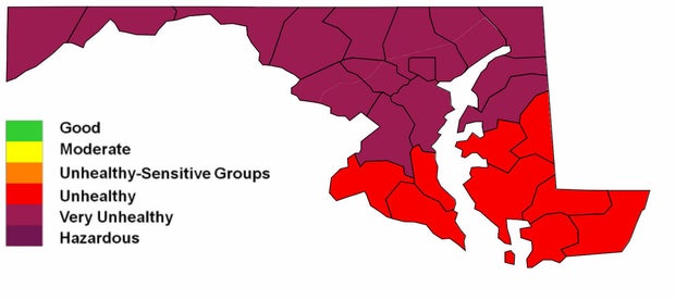
Friday is a First Alert Weather Day due to thick wildfire smoke and poor air quality across much of Maryland.
Saturday will also be a First Alert Weather Day due to impacts from scattered severe storm, primarily during the afternoon and evening hours.
Poor air quality in Baltimore through Friday evening
Air quality will remain very unhealthy deeper into Friday evening. Avoid spending extended periods of time outside, especially if you're working or exercising. A Code Purple Air Quality Alert is in effect for the entire Baltimore area and most of Maryland. That means there's the potential for very unhealthy conditions due to fine particles in the air.
You should remain indoors as much as possible.
Temperatures only slowly cool back through the 80s and into the upper 70s by late evening. Humidity will increase after sunset. The evening forecast remains dry.
Saturday severe storms, heavy rain threat in Maryland
Expect a warm and muggy weekend, with strong to severe thunderstorms on Saturday, which is a First Alert Weather Day due to the risk of severe thunderstorms and heavy rain.
A few showers and storms are possible in the morning, but the greatest chance of storms will hold off until the afternoon and evening. The chance of severe weather peaks between 4 and 8 p.m. across the immediate Baltimore metro. Any storm that develops on Saturday could produce damaging winds, torrential downpours and frequent lightning.
An isolated tornado or two cannot be ruled out, especially across northern and northeastern Maryland. Have at least one way to be alerted to severe weather. Temperatures will top out in the upper 80s and 90s ahead of stormy weather. It'll feel even hotter with humidity factored in.
Sunday may feature spotty showers and storms, mainly south of our area. It looks much drier than Saturday, overall. Sunday is the 'pick day' of the weekend.
The next chance of storms, possibly severe, arrives on Tuesday. There is still some uncertainty with the exact timing of this round of rain and storms. Please continue to check back with the First Alert Weather Team for future updates.