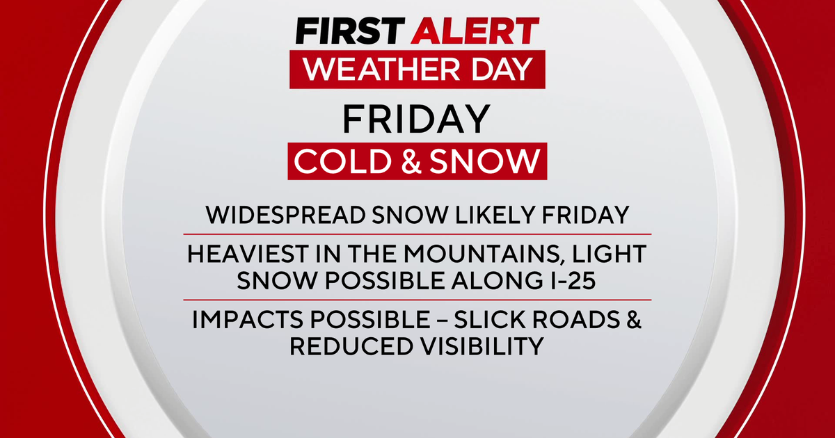
Stormy Friday for North Texas...
STORMS LIKLEY FOR OUR FRIDAY…
The big upper level low that has been spinning over the western part of the country is on the move. It is currently over Colorado and moving into the Central Plains. This system has spawned storms along the dryline in northwest Texas and western Oklahoma. That is where a Tornado Watch is in effect. No counties in North Texas are under a Watch at this time.
We will be watching to see if more storms can develop along the dryline overnight and form a complex of storms that heads toward North Texas. There is the chance that this could happen and bring a round of storms to the metroplex during the morning hours on Friday. This would complicate the prospects for storms Friday afternoon and evening. If we do get storms in the morning, the threat of additional storms in the afternoon and evening will not be as high especially for areas west of Fort Worth. If no complex of storms develops tonight, we will likely see storms develop during the midday hours on Friday and continue into the afternoon and evening. Severe weather will be possible in both scenarios, but much more so if we are rain free in the morning. Large hail and damaging winds will be the main threat. A few tornadoes can't be ruled out, but there is not a large degree of low level wind sheer expected in our area tomorrow.
Some areas could see 1" to 2" of rain tomorrow especially those areas from Dallas to Paris. Low temperatures tonight will be in the mid to low 70s and highs tomorrow thanks to the rain and clouds will only be in the low 80s.
SATURDAY…
This will be a warm, muggy day with temperatures in the upper 80s and low 90s. Storms will once again be possible with areas east of Dallas the favored location for storms.
SUNDAY…
Another sticky day with temperatures around 90 degrees. The dryline will reestablish itself out west where more storms will be possible. Best storm chances on Sunday will be west of Fort Worth, but storms may roll closer to the metroplex Sunday evening and night.
EARLY NEXT WEEK…
More muggy and warm weather on Monday and Tuesday with highs around 90 degrees. Storms will once again be possible along the dryline on Monday and Tuesday west of Fort Worth. Each day will have to be watched to see if those storms can make a run for the DFW area.