Rainy Weather On The Way For Rangers Game
RAIN MOVES INTO AREA TONIGHT…
A large upper level low is located over West Texas this afternoon. This is brining heavy rain and severe weather to the southern part of the state. Tornado Watch and Severe Thunderstorm Watches are in place from Austin and San Antonio down to Brownsville. There have been several tornado warnings this afternoon between San Antonio and Corpus Christi. All this severe weather will stay in South Texas tonight.
We are awaiting some rain to arrive later tonight. The lowest levels of the atmosphere remain dry here across North Texas so has rain is trying to spread up from the south it is having a tough time as the dry air is evaporating the rain. But eventually, the moist air will win out and showers will be likely over night tonight into tomorrow morning.
Here is a radar snapshot at 330pm. Note the cluster of storms to our south. This cluster of storms will continue to grow in scale this evening and slowly move eastward toward Houston. This complex of storms will have an impact on our rain chances. There is the possibility that as storms continue to our south, they will suck up all the moisture and not allow it to spread into North Texas. This would really limit our rainfall amounts. We would likely still see some rain and light showers, but the heaviest of the rain would stay to our south. Several of our high resolution forecast models are indicating this possibility. But when you look at the big area of rain back towards Abilene, it would make sense that some of that rain would spread into DFW overnight tonight. However, that area of rain could be weakened if the drier air that is currently in place continues to do its part to evaporate rain trying to move into North Texas.
FRIDAY'S FORECAST… WILL THE RANGERS GAME HAPPEN?
The strong upper level low that you see on the map below will be moving over North Texas tomorrow. What this will likely do is generate showers and thunderstorms during the afternoon and evening for our Friday. There will likely be clouds and light rain and drizzle with us in the morning on Friday with some areas of dry weather. As we move into the afternoon showers and thunderstorms will increase in coverage. There is a pretty good shot of seeing rain and possibly thunderstorms at the ballpark Friday evening.
Here is how the day will look for our Friday with rain coverage denoted by the percentage.
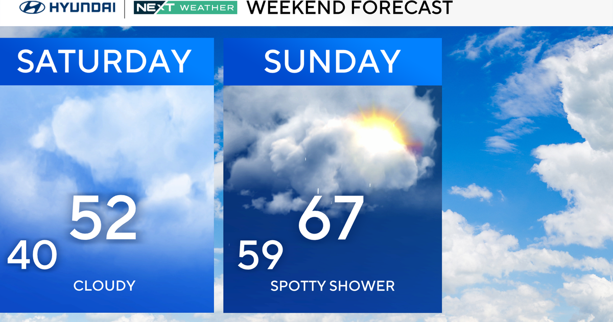
Finally, here is the forecast for the Ranges Weekend Games against the Angels.
Here is a link to a video animation of our High Resolution Forecast Model from 3pm


