First Alert Weather: Rain showers continue, thunderstorms likely
We'll see light to moderate rain showers in the Sacramento region Thursday, with the possibility of urban flooding, and downed trees. In the Sierra, expect to see heavy snow.
Sacramento County lifts Evacuation Order for Point Pleasant residents
Sacramento County has lifted the Evacuation Order for residents living in the Point Pleasant area. They also lifted the Evacuation Warning for Glanville Track and Franklin Pond and the Shelter in Place Order for residents in the Wilton area.
Rain and winds are expected this upcoming weekend and going into next week, and sandbag locations can be found below.
• Branch Center (3847 Branch Center Rd.)
• Orangevale Community Center (6826 Hazel Ave.)
• Point Pleasant United Methodist Church (3329 Point Pleasant Rd.)
• Westside Park (6555 West 2nd St.)
• Wilton Fire Station (10661 Alta Mesa Rd.)
There is a 20-bag limit per visit.
Chain controls now in effect on I-80 eastbound
According to Caltrans, chain controls are now in effect on I-80 eastbound Nyack to Truckee and westbound from Truckee to Drum.
Sacramento morning weather forecast: Jan. 6, 2023
Here is how the next seven days of weather are going to look.
Mudslide closes I-80 off-ramp
A rock and mud slide forced a closure of the Ophir off-ramp on I-80 in Auburn Thursday night.
Caltrans said the eastbound side was not affected.
No injuries have been reported.
Current PG&E outages
Pacific Gas and Electric said Thursday night that, as of 9 p.m., there were still 1,167 outages affecting nearly 61,000 customers across the North Coast, Bay Area and Central Coast areas.
Additionally, the utility released numbers for more local areas. There were still 385 customers experiencing outages as of the same timeframe. Sacramento had 452, and the Sierra had 1,063.
PG&E said crews were mobilized across Northern and Central California working to restore power to everyone amid the ongoing storm.
Spinouts on Highway 20
Caltrans said Highway 20 is closed from six miles east of Nevada City to the Interstat 80 connector due to spinouts and a disabled big rig.
It is unclear when the roadway will reopen.
I-80 traffic halted, Hwy. 50 reopens
Traffic on Highway 50 is flowing again after being held from Echo Summit to Meyers due to spinouts. Chain controls are still in place from Kyburz to Meyers.
Eastbound Interstate 80 is also being held at Castle Peak due to spinouts. The westbound lanes remain open with chain controls.
Sierra chain controls still in place
Caltrans said chain controls were in place across multiple Sierra highways.
Interstate 80
- Between Truckee and Drum Forebay
Highway 50
- Between Kyburz and Meyers
State Route 28
- Between Tahoe City and Kings Beach
State Route 89
- Between Truckee and Tahoe City
You can check up-to-date road restrictions here.
Two more storm systems on the way
Placer County road closed
Authorities are urging people to avoid multiple roadways in rural Placer County due to flooding.
As seen in a video taken by a deputy, South Brewer Road west of Lincoln is almost fully inundated with water between Nicolaus Avenue and Moore Road.
Deputies say the situation is an important reminder for drivers to remember the adage "turn around, don't drown" when happening on a flooded road.
Additionally, West Wise Road between Nicolai and Moore roads was also closed due to floodwater.
Snow closes SR-88 at Carson Pass
Heavy snow, limited visibility and avalanche danger have forced a closure of State Route 88 at Carson Pass, the CHP South Lake Tahoe said late Thursday afternoon.
At this time, it is unclear when the roadway will reopen.
Avalanche control at Echo Summit
Highway 50 at Echo Summit was closed for avalanche control. There is no estimated time for the reopening of the highway.
I-80 traffic being held
Caltrans says westbound traffic is being held on Interstate 80 at Truckee due to spin-outs.
Heavy snow is impacting the high country Thursday afternoon.
Another jackknifed big rig in the Yuba Gap is causing the problem. CHP says a semi-truck and two other vehicles were involved.
No injuries have been reported.
A jackknifed big rig was caught on video earlier on Thursday morning, but crews were able to move that wreck so that traffic could get through.
Thunderstorms still possible
Forecasts show that isolated thunderstorms are still possible into the late afternoon and evening hours on Thursday in Northern California.
Lightning, brief heavy rain, and small hail are all possible.
Dillard Road closed
Dillard Road is now closed again, California Highway Patrol says.
The closure is a precautionary measure in case of flooding or a potential levee break. Officers said on Thursday that they have received reports of a levee break, but they haven't been able to confirm one.
Caltrans is helping with the closure.
Officials are also monitoring if Highway 99 will need to be closed. Caltrans crews are in place in case there is a need for a closure.
Santa Cruz County hit hard
Santa Cruz evacuated its wharf Thursday as the bomb cyclone continued to bear down on the coastal city, massively damaging piers and other structures along the way.
City officials posted about the evacuation on Facebook at around 9 a.m. Thursday morning. They asked that residents stay inside during the storm to stay safe and not to stand outside to watch the storm-drive chaos.
Parade of atmospheric rivers continues into next week; here's what to expect
Although the most powerful part of this storm has moved on, there's more extreme weather on the way. A series of atmospheric rivers is aimed at Northern California that will bring more snow, rain, and strong winds next week.
Read more: https://www.cbsnews.com/sacramento/news/parade-of-atmospheric-rivers-continues-into-next-week-heres-what-to-expect/
Dramatic crash video
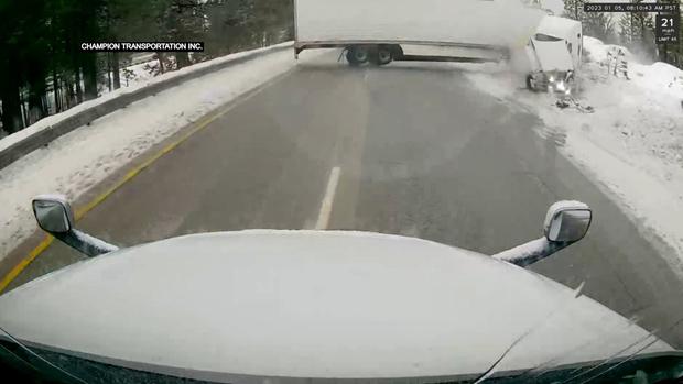
A big rig slid in the Sierra snow and jackknifed right in front of another semi-truck – and it was all caught on video.
The incident happened Thursday morning in the Yuba Pass, near the Interstate 80 and Highway 20 junction.
Road closures in Folsom
The Folsom Police Department says these roads are currently closed, as of 7:20 a.m.:
- East Natoma St between Randall Dr. and Cimamaron Cir. (Tree in Roadway)
- Sibley between Blue Ravine and Levy (Flooding)
The Department is urging drivers to use alternate routes and stay home if they don't need to drive.
Power outages continue in wake of powerful storm
The storm that moved through our region starting Wednesday is causing widespread outage impacts due to wind, flooding, and soil instability.
PG&E and SMUD reported on the number of customers still without power.
Read more: https://www.cbsnews.com/sacramento/news/power-outages-continue-in-wake-of-powerful-storm/
California reservoirs still have room
Major water supply reservoirs around Northern California still have plenty of room, even after the recent series of storms.
Still, some reservoirs are up relative to their seasonal average.
As of Thursday, Folsom Lake is at 421.20', which is 55 percent of total capacity but 133 percent of the historical average for the date.
Sacramento morning weather forecast: Jan. 5, 2022
Lightning lighting up the sky
Sacramento nighttime weather forecast - 1/4/23
Slick roads, debris make for dangerous driving conditions
Stockton sets up emergency shelter as storm hits city
Chain controls in the Sierra
Chain controls were back in effect for Sierra highways.
Caltrans said the restrictions apply to Highway 50 between Twin Bridges and Meyers, while the restrictions on I-80 are from Kingvale to Donner Lake.
The storm is expected to bring even more snow through the overnight hours and mountain travel is highly discouraged during that time.
Stay up to date on road conditions here.
Mobile13 takes you through the storm along I-5
Wednesday storm update - 10 p.m.
Fallen trees knock out power, block roadways
Multiple fallen trees were reported around the region, with some knocking out power for utility customers.
In Roseville, a tree that fell onto power lines has had power out for at least 100 customers for an hour. Power isn't expected to be restored until early Thursday morning.
Heavy winds blew down a tree in Loomis that knocked out power for more than 175 customers. The downed power lines were along Horseshoe Bar Road. There was no estimated time for power restoration.
Steve Large covered the storm in Placerville. In one neighborhood, he spotted a tree that fell onto some power. CBS13 also spotted a tree that fell near a house. In total, more than 1,200 customers were without power with no estimated time for restoration.
Late Wednesday night, Laura Haefeli was in Sacramento County along Levee Road near Del Paso Road where the weather knocked trees and power lines.
A downed tree was blocking traffic on Highway 49 near Joeger Road in Placer County this evening. This has since been cleared. Cal Fire NEU said there were actually multiple reports of downed trees across the area Wednesday.
Earlier in the evening in Sacramento, a fallen tree on Highway 50 was blocking traffic near Bradshaw Road. That has also since been cleared.
The brunt of the winds and rain is expected to hit Sacramento during the overnight hours. SMUD has warned that this timeframe poses a huge risk of fallen trees and extended power outages.
At one point during the evening, nearly 13,000 SMUD customers were without power. SMUD worked to clear fallen trees and fix damaged power lines to restore power.
Avalanche control at Carson Pass
Caltrans said Highway 88 at Carson Pass is closed due to avalanche control. There is no estimated time for the reopening of the highway.
Explainer: What is a weir?
Throughout Wednesday's storm coverage, you may have heard the term "weir" several times. Here's a quick explainer of what that is.
When water gets too high on the Sacramento and American rivers, the state can divert water to keep Sacramento from flooding.
Both rivers merge at Discovery Park north of downtown. The Sacramento Weir is in West Sacramento along River Road
Through the weir, the state can open the gates and actually suck water from both rivers into the Yolo Bypass under the Yolo Causeway. That's the stretch that connects Davis and West Sacramento.
There are other weirs upstream including the Fremont Weir west of Sacramento International Airport.
Heavy rain, stronger wind gusts moving toward Sacramento
Lightning along Highway 49
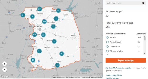
More SMUD outage improvements
More SMUD customers had their power restored Wednesday evening.
As of 7:25 p.m., the utility's outage map showed 660 customers had no power. Just after 5 p.m., that number was closing in on 13,000.
There were still 63 active outages sprinkled around the county, with the majority of the affected customers in the Arden area.
Third body found in flood waters
After a second body was recovered Wednesday in the same Sacramento County area that was flooded after the New Year's storm, a third person was found dead in a vehicle submerged in water along the Mokelumne River.
The second body, a female, has been identified by the Sacramento County coroner as Mei Keng Lam, 57, of San Leandro.
Bradshaw Animal Shelter needs your help
Sacramento County wants to make sure your four-legged friends stay safe as the storm blows through.
The Bradshaw Animal Shelter is out of space.
"We are full. We need help," said Luna Anona, a spokesperson with county Animal Care Services.
When wicked weather hits, the shelter anticipates an influx of lost pets and strays that need help. But right now, they already have at least 189 dogs and only 106 kennels.
"We really need all hands on deck," Anona said. "We're looking for emergency storm fosters to come pick up a dog for at least one week."
Read the full story here.
Tree falls on Highway 50
A fallen tree was blocking multiple lanes on Highway 50 at Bradshaw Road in Sacramento. Caltrans said crews were on the way to clear the scene.
Progress made on SMUD outages
Just more than 1,600 SMUD customers were without power late Wednesday afternoon as another major storm has begun impacting the region.
That's a sharp decline from earlier in the afternoon when nearly 13,000 customers were experiencing outages.
According to the utility's outage map, as of 6:15 p.m., there were 68 active outages all across the county.
With the wind and rain expected to pick up through the night, more severe outages may occur due to downed trees and power lines.
Close eye kept on wildfire burn scars
With another major storm moving through Northern California, officials are keeping a close eye on burn scars for possible debris flows.
Weather conditions near the Mosquito Fire burn scar rapidly changed at around 2:30 p.m. Wednesday to heavy winds and rain after a brief afternoon lull.
Three inches of rain in a short period of time is the number to watch. Efforts to minimize mudslides started even when the Mosquito Fire was burning in Placer County in the fall. But Placer County is equally concerned about high winds knocking down trees and lines and blocking roads.
Read the full story here.
Current weather conditions - 5 p.m.
San Francisco International Airport diverting some flights to Sacramento
A Sacramento International Airport spokesperson tells CBS13 that the airport is seeing some flights being diverted from San Francisco to Sacramento due to high winds.
The spokesperson says San Francisco International Airport (SFO) has stronger crosswinds, which makes landing planes more difficult.
See the full list of flights delayed and canceled at SFO, here.
SMUD power outages affecting thousands
More than 12,900 SMUD customers were without power late Wednesday afternoon as another major storm has begun impacting the region.
According to the utility's outage map, as of 5:10 p.m., there were 78 active outages all across the county, with the majority of the outages coming from the south Sacramento area.
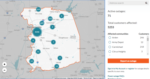
The estimated time for restoration is unknown at this time.
Galt, Lodi park closures
The cities of Galt and Lodi said all parks are closed effective Wednesday due to the potential dangers the storm brings.
The Galt closure is expected to last through at least Friday, which is when city officials will evaluate the park conditions to determine if reopening is possible.
Lodi city officials said trees and branches still impacted by the New Year's Eve storm have been falling.
Current weather conditions - 4 p.m.
Heavy rainfall is moving its way east from the coast in this update from the top of the 4 p.m. show.
Levee breach locations confirmed
Sacramento County officials have confirmed the locations where the Cosumnes River breached levees in the past storm on New Year's.
The following is a map with all the locations plotted:
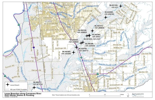
Ten of the breaches are along the Cosumnes River, west of Highway 99 to east of Wilton, while an eleventh breach is along the Mokelumne River, west of I-5. At least two of the eleven breaches are full-on breaks, meaning there is a clear cut in the water barrier.
One of the two breaks, dubbed the Bradley Break, is on the north side of the Cosumnes and is about 2,000 feet wide. It is located east of Wilton Road. As of Wednesday morning, there was a patch at the break that was seven feet tall.
A larger 3,000-foot break is on the south side of the Cosumnes near the Laguna Del Sol nudist resort. The county said Wednesday that the reclamation district has yet to reach this break because the water is high and the Bradley Break is of a bigger concern,
Crews have been hard at work fixing and patching the levees, even as the rain started up again on Wednesday.
Davis opens charging center
The City of Davis is opening a center where people charge their devices if their power goes out.
Officials say the Veterans Memorial Center at 203 E. 14th Street will be open from 12 p.m. to 5 p.m. until the end the week.
Water and restrooms will also be available at the center.
City of Davis officials say the charging center may be extended into the weekend if power outages persist.
Chain controls dropped on I-80
Caltrans says chain controls have been dropped in both directions on Interstate 80. They urge drivers to slow down.
Get real-time road conditions with Caltrans QuickMap.
Newsom signs emergency declaration
California Gov. Gavin Newsom signed a state emergency declaration as the storm approached Wednesday morning.
Officials from the California Office of Emergency Services say the proclamation will allow for an expedited state response.
Auburn parks closed
Auburn is the latest city to close all its parks due to concerns about the coming storm.
City of Auburn officials say the closure is expected to last until Thursday, but could extend until next week.
Saturated soil and tree hazards are the primary concerns prompting the closure, officials say.
Chain controls up on I-80
Chain controls are now in effect on Interstate 80.
CHP Truckee says westbound is at R2 restrictions from Donner Lake Interchange to Rainbow.
Eastbound is also R2 from Kingvale to the Donner Lake Interchange.
For the moment, no restrictions are in effect on Highway 50.
Levee repair work continues
Even as rain starts to fall on Wednesday, work crews are busy trying to make repairs to levees breached in the previous storm.
Crews are out on the now-called "Bradley Break" and are reinforcing the breach with rocks.
Six Flags closes for the day
Six Flags Discovery Kingdom has closed for Wednesday due to the storm.
The park says any tickets purchased already will be honored for any remaining operating day of Holiday in the Park.
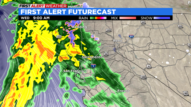
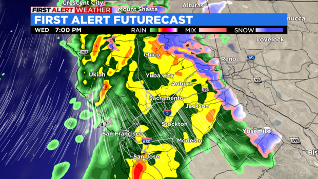
Forecast Update
CBS13's Chief Meteorologist Nic Merianos breaks down the latest forecast on the coming storm:
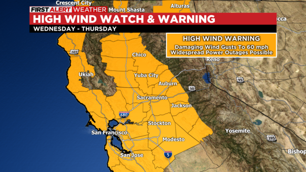
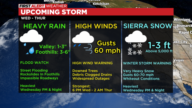
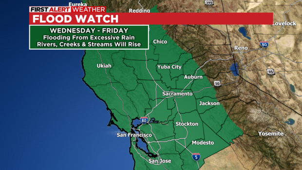
WEATHER ALERTS:
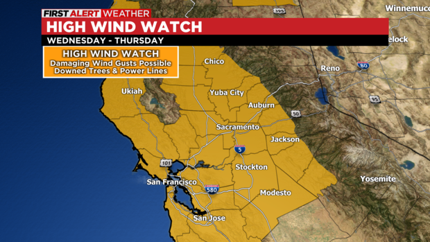
High Wind Warning: Valley & Foothills
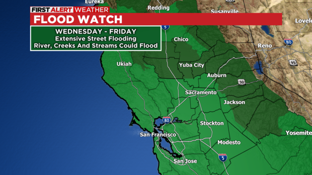
Flood Watch – Valley & Foothills
Flash Flood Watch: Foothills (Burn Scar Areas)
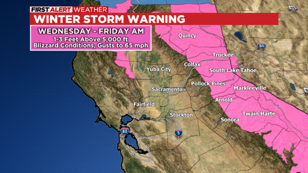
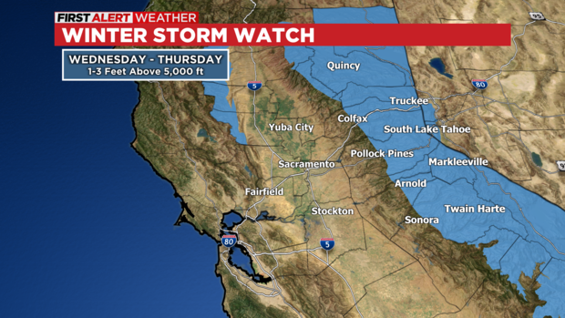
Winter Storm Warning- Sierra
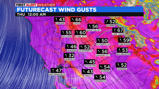
STRONG TO DAMAGING WINDS:
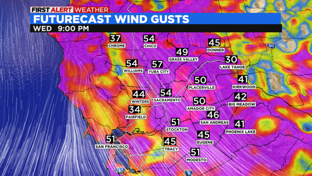
Southerly winds will increase Wednesday afternoon bringing a period of strong to damaging wind gusts. The Valley and Foothills may experience wind gusts approaching 50-60 mph. The combination of high winds and wet grounds will have the potential to bring down or uproot numerous trees. This will result in the potential for widespread and prolonged outages. The core of the damaging winds will likely arrive between 5pm and 2am.
Debris, such as branches, may clog storm drains or dam rivers. This would exacerbate any flooding in areas where this occurs.
Charge up your electronics and ensure your flashlights are in working order.
HEAVY RAIN:
Rain will move into our area, becoming heavy at times Wednesday morning. Urban flooding and street flooding may rapidly develop, especially with already saturated soils. The first batch of rain will lift to the northeast with parts of the Valley getting a break midday. Another batch of very heavy rain will swing through later in the day and continue into the overnight. The second batch of rain will pose the greatest threat for renewed flooding.
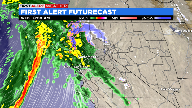
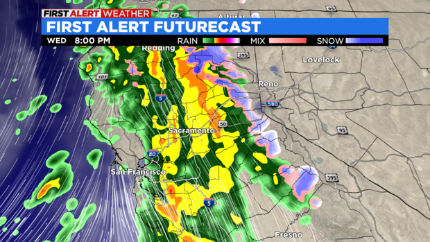
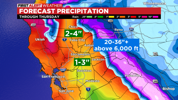
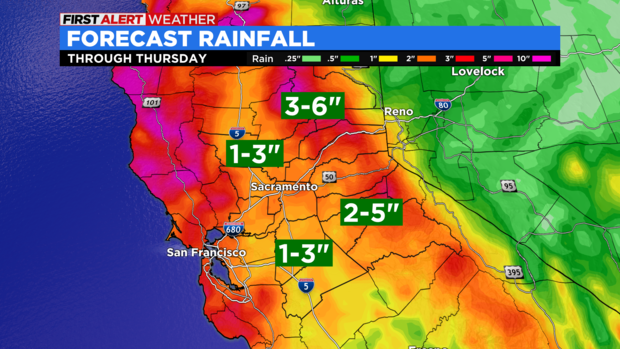
The rain will taper off Thursday morning with off and on showers through the rest of the day. Rainfall totals will likely range from 1-3 inches in the Valley to 2-5 inches in the Foothills. Isolated rainfall amounts of 4 inches in the Sacramento Valley and 6 inches in the Sierra Foothills.
People in the Valley can expect extensive street flooding with roads becoming impassible at times, especially in flood prone areas. Heavy rain in the Foothills may result in additional rockslides and flooding along rivers, creeks and streams. Roads may become impassible in flooded areas.
The Cosumnes and Mokelumne Rivers will both be ones to watch, especially where breaches/ breaks have occurred. Many small creeks and streams may approach flood stage. This must be monitored as a few may reach minor or moderate flooding.
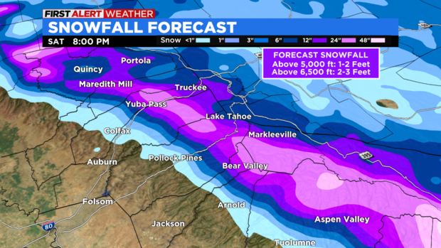
HEAVY SNOW:
Snow in the Sierra will become heavy Wednesday morning with snow levels as low as 4,000 ft. Snow levels will quickly rise to 7,000 ft Wednesday afternoon before falling back to 4,500 ft Thursday morning. Travel will be very difficult with whiteout conditions, chain controls and expected road closures.
Snowfall will range from 1-2 feet above 5,000 ft to 2-3 feet above 6,500 ft. Snow will taper off on Thursday.
SUMMARY:
Widespread impacts are expected Wednesday and Thursday across our entire region. We don't anticipate widespread river flooding, although there will be some along the smaller creeks and streams. However, the combination of saturated grounds and potentially clogged drains from debris will result in significant street flooding. The Cosumnes and Mokelumne should be monitored closely.
Localized impacts associated with runoff and poor drainage may linger into Friday. Much of Friday will be quiet weather-wise from additional rain. Most rivers will likely crest near or below flood stage Thursday with larger rivers cresting sometime on Friday.
Another atmospheric river event will impact our area late Saturday into Sunday. This will renew the potential for additional flooding across our area. Please continue to monitor the forecast for the latest information in the days ahead.
Bradshaw Animal Shelter trying to make room
In anticipation of the surge of lost pets with the coming storm, the Bradshaw Animal Shelter is trying to make room for large dogs.
Kennels are already full, the shelter says, so fosters are desperately needed.
People who can become an emergency storm foster care provider are being urged to visit the shelter on Wednesday, Thursday or Friday to take home a pup. No appointment is necessary.
Sandbag locations
Amador
Details
- Airport parking lot near the County General Services Administration Building in Martell
Calaveras County
- Fire Company 3 at 1601 Jenny Lind Rd.
- Mangili Road behind Power Up Fitness Gym in Valley Springs
- Vista Del Lago by the Mobile Gas Station
- County Public Works Yard at Jenny Lind.
El Dorado County
Details
- Fire Station 32 at 4770 Sandridge Rd., Placerville
- Fire Station 85 at 1050 Wilson Boulevard, El Dorado Hills
- El Dorado County DOT at 3671 Missouri Flat Road, Diamond Springs
- El Dorado County DOT 4120 Ricci Road, Greenwood
- Fire Station 89 at 3200 Country Club Drive, Cameron Park
- El Dorado County DOT 6701 Pony Express Trail Pollock Pines
- Meeks Bay Fire 8041 Highway 89, Meeks Bay
- South Lake Tahoe Fire Station 3 at 2101 Lake Tahoe Blvd., South Lake Tahoe
- Search & Rescue building at 1834 Santa Fe Road, South Lake Tahoe
Placer County
- To see a map with locations, click here.
Plumas County
Details
- Chester/Lake Almanor area: Chester Fire Station
- Eastern Plumas County: Portola Fire (north station on Gulling Street)
- Indian Valley: Indian Valley Fire Station (located south of Greenville on Hwy. 89)
- Quincy area: Feather River College baseball parking lot
Sacramento County
Details
- County Branch Center at 3847 Branch Center Rd. in Sacramento
- Dillard Ranch at 9857 Dillard Road in Wilton
- Orangevale Community Center at 6826 Hazel Ave.
- Point Pleasant United Methodist Church at 3329 Point Pleasant Rd. in Elk Grove
- Westside Park at 6555 West 2nd St. in Rio Linda
- Wilton Fire Station at 10661 Alta Mesa Rd
San Joaquin County
Storm updates page
- Boyd Service Center, located at 520 Tracy Blvd, Tracy. Gate #1. There is a self-serve area with a limit of 10 bags.
- 210 E. Wetmore Street in the Southeast parking lot - Manteca
- Manuel Valverde Park parking lot, located at 15557 5th Street, Lathrop
- Thorton Fire at 12449 W. Walnut Grove Rd Thornton.
- Oak Park Little League parking lot: 3545 Alvarado Avenue, Stockton
- (Former) Van Buskirk Golf Course: 1740 Houston Avenue, Stockton
- 95206 @ S. Fresno Avenue, Stockton
- Farmington Fire District - 25474 E. Hwy 4, Farmington
- Waterloo-Morada Fire Distrcit - 6925 E. Foppiano Lane, Stockton
- Mokolumne Fire District - 13157 E. Brandt Road, Lockeford
- French Camp Fire District - 310 French Camp Road
- Lathrop-Manteca Fire Distrcit - 22701 S. Union Road, Manteca
- Linden Peters Fire District - 17725 E Hwy 26, Linden
- Woodbridge Fire District - 400 E. Augusta Street, Woodbridge
- Clements Fire District - 18901 E. Hwy 88, Clements
- Liberty Fire District - 24124 N. Bruella Road, Acampo
- Mountain House Fire District - 911 Tradition Street, Mountain House
- Ripon - Filling Station is located behind Fire Station 1 at 142 S. Stockton Avenue.
(To access the sandbag filling station, use Nourse Street.) - South County Fire-New Jerusalem Station 93 - 1400 W. Durham Ferry Road, Tracy
Solano County
Details
- Lind Marine/Jericho Dredging at 1285 Collinsville Road 4965 Clayton Road
- 4315 Cantelow Road (English Hills Station), Vacaville
- Sand Bags Are Located At The Dixon Fire Station at 205 Ford Way, Dixon
- Sand is available in the parking lot at the northwest corner of A and Jackson Streets
- Corner Of Rockville Rd And Suisun Valley Road
- Corporation Yard at 2400 East Second Street East E Street Parking Lot, Benicia
- Public Works Corporation Yard - 420 Gregory Street, (Mon-Thurs. 7:30 Am-4:30 Pm) in Fairfield. Empty sandbags can be found in the southeast corner of the parking lot at Allen Witt Park (enter at Woolner) sand only corner of Pittman and Cordelia roads (inside unlocked fenced area) sand only. All locations have a 10-bag limit.
- 1 Main Street Firehouse at 350 Main Street, Rio Vista (sandbags only)
- 701 Civic Center Blvd, Behind Police Department, Suisun City
- Irene Larson Park, 1800 Alamo Drive (bring evidence of residence and a shovel), Vacaville
- Vallejo Flood & Wastewater District at 450 Ryder Street, Vallejo
Sutter County
Details
- City Corporation Yard on N Street in Live Oak
- Meridian Fire Department located at 1100 Third St., Meridian
- Fire Department at 1280 Barry Road, Oswald-Tudor
- Fire Department at 310 Howsley Road, Pleasant Grove
- Community Center at the End of Del Monte, Robbins
- County Sign Yard at 3098 Acacia Avenue, Sutter
- Road Maintenance Yard at 2560 Pacific Avenue, Trowbridge
- Corporation Yard at 1185 Market Street, Yuba City
- Road Yard at 275 Samuel Drive, Yuba City
Yolo County
Details
- Free sandbag material is available at the end of East Street (Between the City of Winters, CA Corporation yard and Yolo Federal Credit Union Building).
- Call 3-1-1 for information on free sandbags
Sacramento County to close parks
The Sacramento County Department of Regional Parks said Tuesday that all parks within its jurisdiction will be closed as of Wednesday with the potential for that to last through Friday.
A large number of trees is expected to be brought down by forecasted string wind gusts and saturated soils.
The closures also include the American River multi-use and Dry Creek Parkway trails.
Find the full list of parks here and their status.
Stockton closes all parks
The City of Stockton is closing all of its parks ahead of the storm.
Officials said on Tuesday, effective immediately, that all of the city parks are now closed to the public due to tree hazards.
Years of drought conditions weakening branches and tree root structures surfacing are among the hazards city officials are concerned about. Many trees have already seen branches fall.
Signs are now being posted at the parks. City officials are telling residents to not access, pass through, or even walk near parks.
Sacramento Zoo closing on Wednesday and Thursday
With another significant storm on the way to Northern California, the Sacramento Zoo will be preemptively closing for the next few days.
The zoo says it will be closed on Wednesday and Thursday.
5th levee breach confirmed
Authorities have confirmed another levee breach along the Cosumnes River in Sacramento County on Tuesday, the fifth one found after New Year's storm.
The breech is about three miles east of Wilton Road on the south bank of the river.
Officials say there are five different breaches on five different owners' land. Of those breaches, two are expected to be fixed by Wednesday.
Trucks full of gravel are now lined up at the location of the fifth breach and are set to get to work.
Another atmospheric river on the way
A strong atmospheric river event has the potential to be one of the most impactful storms Northern California has seen in a while. This storm will have multiple hazards and as of this writing, the following weather alerts are in effect:
Flood Watch – Valley & Foothills
High Wind Watch – Valley & Foothills
Winter Storm Watch- Sierra
HEAVY RAIN:
Rain will move into the area, becoming heavy at times Wednesday morning. Urban flooding and street flooding may rapidly develop, especially with already saturated soils. The first batch of rain will lift to the north and east with parts of the Valley getting a brief break midday. Another batch of very heavy rain will swing through later in the day and into the overnight. It is this batch that will pose the greatest threat of flooding in our area.
Additionally, strong winds may bring down lots of tree debris, potentially clogging storm drains or damming smaller creeks and streams. This could result in significant street flooding with some roads becoming impassable. Flooding in the Foothills may be similar to that of Saturday. Rockslides and road washouts will also be possible.
The rain will taper off Wednesday night with off-and-on showers Thursday. Rainfall totals will likely range from 1-3 inches in the Valley to 2-5 inches in the Foothills. Isolated rainfall amounts of 6 inches will be possible in the Foothills.
The Cosumnes and Mokelumne Rivers will both be ones to watch, especially where breaches/ breaks have occurred. Many small creeks and streams may approach the flood stage. This must be monitored as some may reach minor or moderate flooding.
STRONG TO DAMAGING WINDS:
Southerly winds will increase Wednesday afternoon bringing a period of strong to damaging wind gusts. The Valley and Foothills may experience wind gusts approaching 50-60 miles per hour. The combination of high winds and wet grounds will have the potential to bring down numerous trees (with the root and everything) resulting in widespread outages. The timing of high winds will be from Wednesday afternoon into the overnight. The Sierra may have gusts exceeding 60 miles per hour at times.
It is important to reiterate that storm drains and ditches may become clogged with debris. This could exacerbate areal flooding in spots.
HEAVY SNOW:
Snow in the Sierra will become heavy Wednesday morning with snow levels as low as 3,500 feet. Snow levels will quickly rise to 7,000 feet Wednesday afternoon before falling back to 4,500 feet Thursday morning. Travel will be difficult with very low visibility, while chain controls and closures are expected.
Snowfall will range from 1-2 feet above 5,000 feet to 2-3 feet above 6,500 feet. Snow will taper off on Thursday.

SUMMARY:
Widespread impacts are expected Wednesday and across the Greater Sacramento region. Widespread river flooding is not anticipated, although there will be some along the smaller creeks and streams. However, the combination of saturated grounds and potentially clogged drains from debris will result in significant street flooding. The Cosumnes and Mokelumne rivers should be monitored closely.
Most rivers will likely crest near or below flood stage Thursday with larger rivers cresting sometime on Friday.


