Pittsburgh Weather: Chilly pattern settles in for the work week

PITTSBURGH (KDKA) -- A chilly weather pattern settles in today.
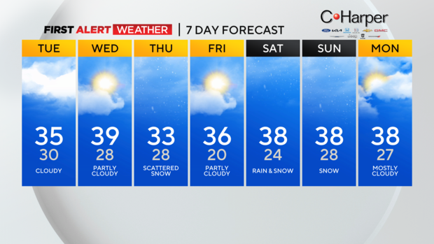
Daily average High: 37 Low: 23
Sunrise: 7:44 Sunset: 5:05
Any Alert Days Ahead? Very real possibility Saturday into Sunday will be. A lot can change before then though.
Aware: Pittsburgh recorded 0.4" of snow yesterday
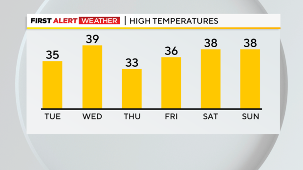
I have Wednesday as the 'warmest' day of the week with highs hitting 39 degrees. Most days will see highs in just the mid-30s. For the second day in a row, model data is really picking up on a gulf low rolling through over the weekend; bringing a chance for big snow totals.
For now, it is something we are watching here at KDKA. A history of systems like this shows that our potential snow totals will be impacted by a mix of rain and snow limiting our impact.
Before we get too much into the weekend snow chance, let's start with today.
Skies should be overcast from start to finish today. We may see some sunshine just before sunset at 5:05 tonight. A couple of isolated snow showers will also be possible, moving in from Lake Erie. Places along and north of I-80 have a better chance of seeing snow today.
I have highs today just in the mid-30s with morning lows hovering in the upper 20s to right at 30 degrees.
Wind chills will dip to the low 20s this morning thanks to westerly winds of 5-10mph.
Wednesday may be the 'warmest' day of the week with highs near 40. I have Pittsburgh hitting 39 now. Skies will be partly cloudy on Wednesday. We will see a weak cool front move through on Thursday, with light snow possible for the morning. Highs on Thursday will hit just the low 30s.
The coldest morning of the week will be on Friday morning with temperatures pegged to drop to the low 20s and teens. Brrrr, bundle up. Friday highs will hit the mid-30s.
Now let's get into the weekend's forecast where model data is jumping on in some cases double-digit snow totals. I look at current model data coming in as a worst-case scenario at this point. We are still a couple of days away and the system that will bring us this chance for snow hasn't even come ashore yet and is churning in the Pacific Ocean.
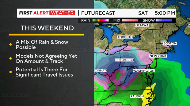
Temperatures and atmospheric profiles point to a rain and snow mix with warm air moving in and lowering potential snow totals.
I have highs hitting the upper 30s on both Saturday and Sunday.
Right now it is certainly too early to know exactly what to expect but we are keeping a close eye on it.
WEATHER LINKS:
Current Conditions | School Closings & Delays | Submit Your Weather Photos


