More mild conditions with rain and snow chances this weekend ahead of Arctic air next week

PITTSBURGH (KDKA) - The snow from yesterday's clipper system has ended for the most part early Friday morning. Cloudy skies and a few flurries linger across the region. For the most part, snow totals were around what we anticipated, with most locations in the Pittsburgh metro area receiving 1-3 inches, including the airport which received 1.7 inches. There were a few isolated higher 4-5 inch totals, but these were few and far between. Most reports coming out of the Laurel Highlands range between 4-6 inches and 1-3 inches also fell along the I-80 corridor as well.
WEATHER LINKS:
Current Conditions | School Closings & Delays | Submit Your Weather Photos
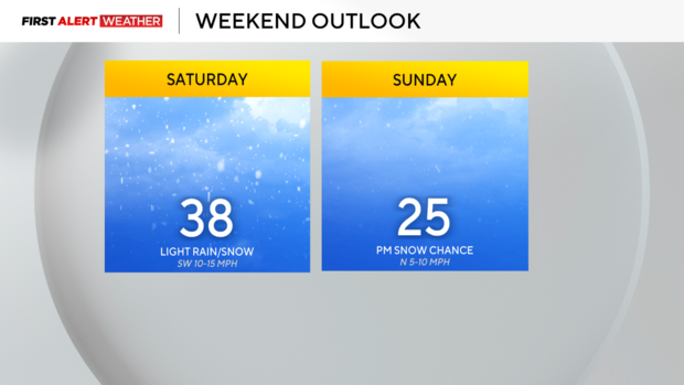
Temperatures this morning are not as cold compared to previous days this week, thanks to a west to southwest wind at the surface. Expect highs to reach the lower to mid-30s in the afternoon. Some decrease in cloud coverage is possible later in the day. This brief "warm up" will last into Saturday ahead of a strong Arctic cold front. Moisture moving in ahead of the front will set us up for a light rain/snow mix beginning after sunrise Saturday lasting through the night. More snow is expected generally north of Pittsburgh, while precipitation will tend to mix with more rain south of Pittsburgh. The snow and rain should taper off Saturday evening after sunset, with partially clearing skies overnight. Clouds are expected to increase again on Sunday during the day, as another fast-moving trough aloft in the atmosphere passes by just to the southeast. This system, along with some low-level cold winds coming out of the northwest, will likely produce some light snow in the afternoon on Sunday, with minor accumulations possible in the Laurel Highlands and Ridges.
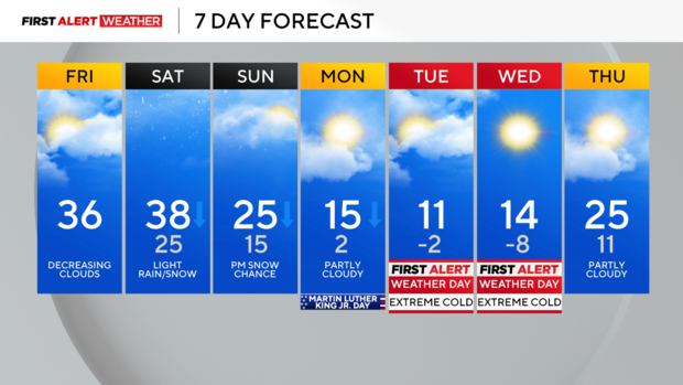
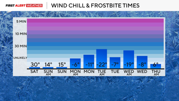
The coldest air of the season will gradually transfer into our region starting on Sunday. High temperatures will likely occur early in the day on Sunday and Monday before a slow downward trend each day. The peak of the cold looks to be Tuesday into Wednesday, with lows on Tuesday and Wednesday mornings well below zero. Wind chills will likely be in the -10 to -25 degree range across our area during this event. This is much closer to the range that is actually considered dangerous, and frostbite can occur within 30 minutes on exposed skin, so take precautions and cover up well when going outside. The coldest morning will likely be Wednesday as high pressure settles into the region, before warmer winds from the southwest bring an end to the cold spell by the end of next week.
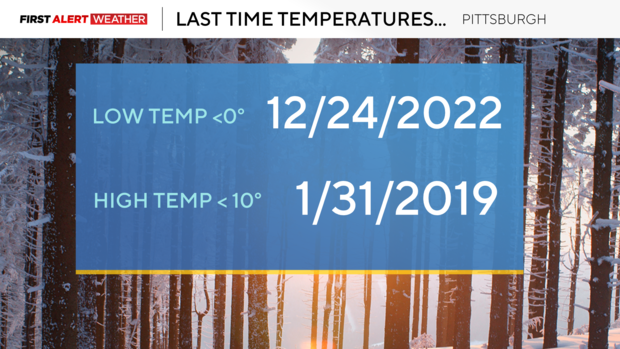
The last time Pittsburgh International Airport recorded a high temperature less than 10 degrees was on January 31, 2019; the last time a low temperature below zero occurred was on December 24, 2022.
Stay up to date with the KDKA Mobile App – which you can download here!


